CURRENT AFFAIRS – 01/06/2024
- CURRENT AFFAIRS – 01/06/2024
- Manufacturing sector’s growth lifts GDP to 8.2% / विनिर्माण क्षेत्र की वृद्धि ने जीडीपी को 8.2% तक बढ़ाया
- Fiscal deficit in FY24 narrowed to 5.6% on better tax mop-up / वित्त वर्ष 2024 में बेहतर कर संग्रह के कारण राजकोषीय घाटा घटकर 5.6% रह गया
- India eyes Mongolia for key minerals to bypass China route / भारत चीन के रास्ते को दरकिनार करते हुए प्रमुख खनिजों के लिए मंगोलिया पर नज़र रख रहा है
- KAZA 2024 Summit / काज़ा 2024 शिखर सम्मेलन
- Gaza Strip / गाजा पट्टी
- Heat-baked Chennai can set an example for India / गर्मी से तपता चेन्नई भारत के लिए एक मिसाल बन सकता है
- Major Physical Divisions of Asia [Mapping] / एशिया के प्रमुख भौतिक विभाग [मानचित्र]
CURRENT AFFAIRS – 01/06/2024
Manufacturing sector’s growth lifts GDP to 8.2% / विनिर्माण क्षेत्र की वृद्धि ने जीडीपी को 8.2% तक बढ़ाया
(General Studies- Paper III)
Source : The Hindu
India’s real GDP for FY24 grew by 8.2%, exceeding projections and accelerating from FY23’s 7% growth, driven by significant manufacturing sector expansion and robust services performance. The National Statistical Office’s provisional estimates highlighted strong economic momentum despite weather-related disruptions in agriculture.
Importance of Manufacturing Sector in India
- Contributes approximately 15% to India’s GDP and employs around 12% of the workforce.
- Diverse industries include textiles, pharmaceuticals, automobiles, and consumer durables.
- Key driver of economic growth and essential for India’s industrial development.
Challenges Faced by India’s Manufacturing Sector
- Inadequate tech-based infrastructure and skilled manpower.
- Limited access to credit, particularly for MSMEs.
- Shortage of skilled labour hindering sector growth.
- Complex regulations and poor supply chain management.
- Intense competition from other countries and dependence on foreign imports.
Recent Government Initiatives for Industrial Sector Growth
- Production-Linked Incentive (PLI) scheme to boost domestic manufacturing.
- PM Gati Shakti for multimodal connectivity infrastructure.
- Bharatmala Project to improve connectivity in North East India.
- Start-up India to promote a culture of entrepreneurship.
- Make in India 2.0 to transform India into a global manufacturing hub.
- Atmanirbhar Bharat Campaign to reduce import dependence.
Way Forward for Indian Manufacturing Sector
- Investing in infrastructure to attract more investment and businesses.
- Promoting export-oriented manufacturing to tap into new markets.
- Fostering innovation through research and development.
- Improving access to finance for SMEs and MSMEs.
- Streamlining regulations to reduce burdens on businesses.
- Encouraging skill development to address labour shortages and increase competitiveness.
विनिर्माण क्षेत्र की वृद्धि ने जीडीपी को 8.2% तक बढ़ाया
वित्त वर्ष 2024 में भारत की वास्तविक जीडीपी में 8.2% की वृद्धि हुई, जो अनुमानों से अधिक है और वित्त वर्ष 2023 की 7% वृद्धि से तेज है, जो विनिर्माण क्षेत्र के महत्वपूर्ण विस्तार और मजबूत सेवा प्रदर्शन से प्रेरित है। राष्ट्रीय सांख्यिकी कार्यालय के अनंतिम अनुमानों ने कृषि में मौसम संबंधी व्यवधानों के बावजूद मजबूत आर्थिक गति को उजागर किया।
भारत में विनिर्माण क्षेत्र का महत्व
- भारत के सकल घरेलू उत्पाद में लगभग 15% का योगदान देता है और लगभग 12% कार्यबल को रोजगार देता है।
- विविध उद्योगों में कपड़ा, फार्मास्यूटिकल्स, ऑटोमोबाइल और उपभोक्ता टिकाऊ वस्तुएं शामिल हैं।
- आर्थिक विकास का मुख्य चालक और भारत के औद्योगिक विकास के लिए आवश्यक।
भारत के विनिर्माण क्षेत्र के सामने चुनौतियाँ
- अपर्याप्त तकनीक-आधारित बुनियादी ढाँचा और कुशल जनशक्ति।
- विशेष रूप से एमएसएमई के लिए ऋण तक सीमित पहुँच।
- कुशल श्रमिकों की कमी क्षेत्र के विकास में बाधा डाल रही है।
- जटिल नियम और खराब आपूर्ति श्रृंखला प्रबंधन।
- अन्य देशों से तीव्र प्रतिस्पर्धा और विदेशी आयात पर निर्भरता।
औद्योगिक क्षेत्र के विकास के लिए हाल की सरकारी पहल
- घरेलू विनिर्माण को बढ़ावा देने के लिए उत्पादन-लिंक्ड प्रोत्साहन (पीएलआई) योजना।
- मल्टीमॉडल कनेक्टिविटी इंफ्रास्ट्रक्चर के लिए पीएम गति शक्ति।
- पूर्वोत्तर भारत में कनेक्टिविटी को बेहतर बनाने के लिए भारतमाला परियोजना।
- उद्यमिता की संस्कृति को बढ़ावा देने के लिए स्टार्ट-अप इंडिया।
- भारत को वैश्विक विनिर्माण केंद्र में बदलने के लिए मेक इन इंडिया 0।
- आयात निर्भरता को कम करने के लिए आत्मनिर्भर भारत अभियान।
भारतीय विनिर्माण क्षेत्र के लिए आगे का रास्ता
- अधिक निवेश और व्यवसायों को आकर्षित करने के लिए बुनियादी ढाँचे में निवेश करना।
- नए बाजारों में प्रवेश के लिए निर्यातोन्मुखी विनिर्माण को बढ़ावा देना।
- अनुसंधान और विकास के माध्यम से नवाचार को बढ़ावा देना।
- एसएमई और एमएसएमई के लिए वित्त तक पहुंच में सुधार करना।
- व्यवसायों पर बोझ कम करने के लिए विनियमनों को सुव्यवस्थित करना।
- श्रम की कमी को दूर करने और प्रतिस्पर्धात्मकता बढ़ाने के लिए कौशल विकास को प्रोत्साहित करना।
Fiscal deficit in FY24 narrowed to 5.6% on better tax mop-up / वित्त वर्ष 2024 में बेहतर कर संग्रह के कारण राजकोषीय घाटा घटकर 5.6% रह गया
(General Studies- Paper III)
Source : The Hindu
The Indian government’s fiscal deficit for 2023-24 stood at 5.6% of GDP, surpassing earlier estimates of 5.8%, attributed to increased revenue collection and reduced expenditure, as per official data released by the Controller General of Accounts.
Fiscal Deficit:
- Definition: Fiscal deficit refers to the difference between the government’s total expenditure and its total revenue excluding borrowing.
- Calculation: It is calculated as Total Expenditure – Total Revenue (excluding borrowing).
- Importance: Fiscal deficit indicates the extent to which a government must borrow to meet its expenditure needs.
- Funding: Fiscal deficit is often funded through borrowing from domestic or international sources.
Impact of Higher Fiscal Deficit
- Increased Borrowing: Higher fiscal deficit leads to increased government borrowing, which can put upward pressure on interest rates.
- Inflationary Pressure: Increased government borrowing can fuel inflationary pressures in the economy.
- Crowding Out: Higher government borrowing can crowd out private investment by competing for available funds in the market.
- Debt Burden: High fiscal deficits can lead to a higher debt burden, increasing the risk of default and impacting long-term economic stability.
- Credit Rating: Persistent high fiscal deficits can lead to a downgrade in a country’s credit rating, making borrowing more expensive and challenging.
Fiscal Reduction and Management Act, 2003:
- FRBM Act Overview: Enacted in 2003 to ensure fiscal discipline, transparency, and accountability in government spending.
- Fiscal Deficit Reduction: Mandates reduction of fiscal deficit to below 4.5% by 2025-26.
- Elimination of Revenue Deficit: Requires elimination of revenue deficit, which is the excess of government expenditure over revenue.
- Medium-term Fiscal Strategy: Government to formulate and implement a medium-term fiscal strategy outlining plans for deficit reduction over three years.
- Annual Fiscal Reports: Government obligated to present annual fiscal responsibility statement to Parliament.
वित्त वर्ष 2024 में बेहतर कर संग्रह के कारण राजकोषीय घाटा घटकर 5.6% रह गया
महालेखा नियंत्रक द्वारा जारी आधिकारिक आंकड़ों के अनुसार, 2023-24 के लिए भारत सरकार का राजकोषीय घाटा सकल घरेलू उत्पाद का 5.6% रहा, जो पहले के 5.8% के अनुमान से अधिक है, जिसका श्रेय राजस्व संग्रह में वृद्धि और व्यय में कमी को दिया जाता है।
राजकोषीय घाटा:
- परिभाषा: राजकोषीय घाटा सरकार के कुल व्यय और उधार को छोड़कर उसके कुल राजस्व के बीच के अंतर को दर्शाता है।
- गणना: इसकी गणना कुल व्यय – कुल राजस्व (उधार को छोड़कर) के रूप में की जाती है।
- महत्व: राजकोषीय घाटा यह दर्शाता है कि सरकार को अपनी व्यय आवश्यकताओं को पूरा करने के लिए किस सीमा तक उधार लेना चाहिए।
- वित्तपोषण: राजकोषीय घाटे को अक्सर घरेलू या अंतर्राष्ट्रीय स्रोतों से उधार लेकर वित्तपोषित किया जाता है।
उच्च राजकोषीय घाटे का प्रभाव
- उधार में वृद्धि: उच्च राजकोषीय घाटे से सरकार की उधारी बढ़ जाती है, जिससे ब्याज दरों पर दबाव बढ़ सकता है।
- मुद्रास्फीति का दबाव: सरकार की बढ़ी हुई उधारी अर्थव्यवस्था में मुद्रास्फीति के दबाव को बढ़ा सकती है।
- भीड़भाड़: उच्च सरकारी उधारी बाजार में उपलब्ध निधियों के लिए प्रतिस्पर्धा करके निजी निवेश को बाहर कर सकती है।
- ऋण का बोझ: उच्च राजकोषीय घाटे से ऋण का बोझ बढ़ सकता है, जिससे डिफ़ॉल्ट का जोखिम बढ़ सकता है और दीर्घकालिक आर्थिक स्थिरता प्रभावित हो सकती है।
- क्रेडिट रेटिंग: लगातार उच्च राजकोषीय घाटे से देश की क्रेडिट रेटिंग में गिरावट आ सकती है, जिससे उधार लेना अधिक महंगा और चुनौतीपूर्ण हो सकता है।
राजकोषीय कटौती और प्रबंधन अधिनियम, 2003:
- FRBM अधिनियम अवलोकन: सरकारी व्यय में राजकोषीय अनुशासन, पारदर्शिता और जवाबदेही सुनिश्चित करने के लिए 2003 में अधिनियमित किया गया।
- राजकोषीय घाटे में कमी: 2025-26 तक राजकोषीय घाटे को 5% से कम करने का आदेश।
- राजस्व घाटे का उन्मूलन: राजस्व घाटे को समाप्त करने की आवश्यकता है, जो राजस्व पर सरकारी व्यय की अधिकता है।
- मध्यम अवधि की राजकोषीय रणनीति: सरकार तीन वर्षों में घाटे में कमी के लिए योजनाओं की रूपरेखा तैयार करने वाली एक मध्यम अवधि की राजकोषीय रणनीति तैयार करेगी और उसे लागू करेगी।
- वार्षिक राजकोषीय रिपोर्ट: सरकार संसद में वार्षिक राजकोषीय उत्तरदायित्व विवरण प्रस्तुत करने के लिए बाध्य है।
India eyes Mongolia for key minerals to bypass China route / भारत चीन के रास्ते को दरकिनार करते हुए प्रमुख खनिजों के लिए मंगोलिया पर नज़र रख रहा है
(General Studies- Paper II)
Source : The Hindu
Highlights:
- India is seeking to advance into Mongolia to secure coking coal and critical minerals like copper and rare earth elements, aiming to reduce dependence on Chinese imports.
- Joint working groups with the Mongolian embassy have been established to explore collaboration opportunities.
- Evacuation of minerals poses a challenge, as India is reluctant to route through China, prompting exploration of alternative routes through Russia.
- Proposals include forming a consortium of state-run companies to set up required evacuation infrastructure.
- Mongolia is building a washing station for coking coal with a 2024 deadline, offering potential for coking coal exports to India.
- Joint venture tie-ups for copper mining are also being considered by the Mines Ministry.
भारत चीन के रास्ते को दरकिनार करते हुए प्रमुख खनिजों के लिए मंगोलिया पर नज़र रख रहा है
हाइलाइट:
- भारत कोकिंग कोल और तांबा तथा दुर्लभ मृदा तत्वों जैसे महत्वपूर्ण खनिजों को सुरक्षित करने के लिए मंगोलिया में आगे बढ़ना चाहता है, जिसका उद्देश्य चीनी आयात पर निर्भरता को कम करना है।
- सहयोग के अवसरों का पता लगाने के लिए मंगोलियाई दूतावास के साथ संयुक्त कार्य समूह स्थापित किए गए हैं।
- खनिजों की निकासी एक चुनौती है, क्योंकि भारत चीन के माध्यम से मार्ग बनाने के लिए अनिच्छुक है, जिससे रूस के माध्यम से वैकल्पिक मार्गों की खोज की जा रही है।
- प्रस्तावों में आवश्यक निकासी अवसंरचना स्थापित करने के लिए सरकारी कंपनियों का एक संघ बनाना शामिल है।
- मंगोलिया 2024 की समय सीमा के साथ कोकिंग कोल के लिए एक वाशिंग स्टेशन का निर्माण कर रहा है, जो भारत को कोकिंग कोल निर्यात की संभावना प्रदान करता है।
- खान मंत्रालय तांबे के खनन के लिए संयुक्त उद्यम गठजोड़ पर भी विचार कर रहा है।
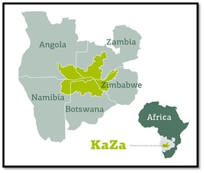
KAZA 2024 Summit / काज़ा 2024 शिखर सम्मेलन
Syllabus : Prelims : Important Summits
At the KAZA 2024 Summit in Livingstone, Zambia, delegates reiterated the urge for member states to withdraw from CITES because they seek approval to trade their plentiful ivory and wildlife items.

Key Objectives of KAZA 2024 Summit :
- Conservation: Promote the sustainable management and conservation of wildlife across the five member states: Angola, Botswana, Namibia, Zambia, and Zimbabwe.
- Economic Benefit: To explore ways to monetize abundant wildlife resources, particularly elephants, to fund conservation efforts and benefit local economies.
Dominant Issues:
- At the 19th meeting of the CITES conference in Panama in 2022, KAZA states and five other southern African countries advocated for opening up trade in ivory and elephant products.
- Southern African countries, including those in the KAZA region, argue that their large elephant populations contribute to habitat loss and human-wildlife conflict.
- Despite repeated requests, CITES delegates rejected the proposal, leading to frustration among African countries.
- Ten countries, including KAZA states and others like Eswatini, Lesotho, Mozambique, South Africa, and Tanzania, declared a dispute with CITES. They criticized CITES for straying from its founding principles and adopting ideologies over science-based conservation strategies.
Way forward:
- Lobbying for Change: Advocacy for a more equitable and science-based approach to wildlife trade regulations within international frameworks like CITES.
- Regional Cooperation: Enhance collaboration among member states to develop joint conservation strategies and share best practices for managing human-wildlife conflicts.
- Diversification of Revenue Streams: Explore alternative sources of funding for conservation efforts, such as ecotourism, carbon credits, and sustainable agriculture.
About the Convention on International Trade in Endangered Species of Wild Fauna and Flora (CITES):
- It is an international agreement adopted in 1973 (entered into force in 1975) between governments.
- Aim: To ensure that international trade in wild animals and plants does not threaten their survival.
- Headquarters: Geneva, Switzerland.
- Although CITES is legally binding on the Parties – in other words, they have to implement the Convention–it does not take the place of national laws.
- Representatives of CITES nations meet every two to three years at a Conference of the Parties (COP) to review progress and adjust the lists of protected species, which are grouped into three categories with different levels of protection:
- Appendix I: Includes the world’s most endangered plants and animals, such as tigers and gorillas. International commercial trade in these species, or even parts of them, is completely banned, except in rare cases such as scientific research.
- Appendix II: Contains species like corals that are not yet threatened with extinction, but which could become threatened if unlimited trade were allowed. Also included are “look-alike” species that closely resemble those already on the list for conservation reasons. Plants and animals in this category can be traded internationally, but there are strict rules.
- Appendix III: Species whose trade is only regulated within a specific country can be placed on Appendix III if that country requires cooperation from other nations to help prevent exploitation.
काज़ा 2024 शिखर सम्मेलन
लिविंगस्टोन, जाम्बिया में आयोजित KAZA 2024 शिखर सम्मेलन में प्रतिनिधियों ने सदस्य देशों से CITES से हटने का आग्रह दोहराया, क्योंकि वे अपने प्रचुर मात्रा में उपलब्ध हाथीदांत और वन्य जीव वस्तुओं के व्यापार के लिए अनुमोदन चाहते हैं।
काजा 2024 शिखर सम्मेलन के मुख्य उद्देश्य:
- संरक्षण: पांच सदस्य देशों: अंगोला, बोत्सवाना, नामीबिया, जाम्बिया और जिम्बाब्वे में वन्यजीवों के सतत प्रबंधन और संरक्षण को बढ़ावा देना।
- आर्थिक लाभ: प्रचुर मात्रा में वन्यजीव संसाधनों, विशेष रूप से हाथियों को मुद्रीकृत करने के तरीकों की खोज करना, ताकि संरक्षण प्रयासों को वित्तपोषित किया जा सके और स्थानीय अर्थव्यवस्थाओं को लाभ पहुंचाया जा सके।
प्रमुख मुद्दे:
- 2022 में पनामा में CITES सम्मेलन की 19वीं बैठक में, काजा राज्यों और पांच अन्य दक्षिणी अफ्रीकी देशों ने हाथी दांत और हाथी उत्पादों में व्यापार खोलने की वकालत की।
- काजा क्षेत्र सहित दक्षिणी अफ्रीकी देशों का तर्क है कि उनकी बड़ी हाथी आबादी आवास के नुकसान और मानव-वन्यजीव संघर्ष में योगदान करती है।
- बार-बार अनुरोध के बावजूद, CITES प्रतिनिधियों ने प्रस्ताव को अस्वीकार कर दिया, जिससे अफ्रीकी देशों में निराशा फैल गई।
- काजा राज्यों और एस्वातिनी, लेसोथो, मोजाम्बिक, दक्षिण अफ्रीका और तंजानिया जैसे अन्य देशों सहित दस देशों ने CITES के साथ विवाद की घोषणा की। उन्होंने CITES की आलोचना की कि वह अपने संस्थापक सिद्धांतों से भटक गया है और विज्ञान-आधारित संरक्षण रणनीतियों की जगह विचारधाराओं को अपना रहा है।
आगे की राह:
- परिवर्तन के लिए पैरवी: CITES जैसे अंतर्राष्ट्रीय ढाँचों के भीतर वन्यजीव व्यापार विनियमों के लिए अधिक न्यायसंगत और विज्ञान-आधारित दृष्टिकोण की वकालत करना।
- क्षेत्रीय सहयोग: संयुक्त संरक्षण रणनीतियों को विकसित करने और मानव-वन्यजीव संघर्षों के प्रबंधन के लिए सर्वोत्तम प्रथाओं को साझा करने के लिए सदस्य राज्यों के बीच सहयोग बढ़ाना।
- राजस्व धाराओं का विविधीकरण: संरक्षण प्रयासों के लिए धन के वैकल्पिक स्रोतों का पता लगाना, जैसे कि इकोटूरिज्म, कार्बन क्रेडिट और टिकाऊ कृषि।
वन्यजीवों और वनस्पतियों की लुप्तप्राय प्रजातियों में अंतर्राष्ट्रीय व्यापार पर कन्वेंशन (CITES) के बारे में:
- यह सरकारों के बीच 1973 में अपनाया गया एक अंतर्राष्ट्रीय समझौता है (1975 में लागू हुआ)।
- उद्देश्य: यह सुनिश्चित करना कि जंगली जानवरों और पौधों में अंतर्राष्ट्रीय व्यापार उनके अस्तित्व को खतरे में न डाले।
- मुख्यालय: जिनेवा, स्विट्जरलैंड।
- हालाँकि CITES कानूनी रूप से पक्षों पर बाध्यकारी है – दूसरे शब्दों में, उन्हें कन्वेंशन को लागू करना है – यह राष्ट्रीय कानूनों का स्थान नहीं लेता है।
- सीआईटीईएस देशों के प्रतिनिधि प्रगति की समीक्षा करने और संरक्षित प्रजातियों की सूची को समायोजित करने के लिए हर दो से तीन साल में पार्टियों के सम्मेलन (सीओपी) में मिलते हैं, जिन्हें विभिन्न सुरक्षा स्तरों के साथ तीन श्रेणियों में बांटा गया है:
- परिशिष्ट I: इसमें दुनिया के सबसे अधिक संकटग्रस्त पौधे और जानवर शामिल हैं, जैसे कि बाघ और गोरिल्ला। इन प्रजातियों या यहाँ तक कि इनके कुछ हिस्सों का अंतर्राष्ट्रीय वाणिज्यिक व्यापार पूरी तरह से प्रतिबंधित है, सिवाय वैज्ञानिक अनुसंधान जैसे दुर्लभ मामलों के।
- परिशिष्ट II: इसमें कोरल जैसी प्रजातियाँ शामिल हैं, जिनके विलुप्त होने का खतरा अभी तक नहीं है, लेकिन अगर असीमित व्यापार की अनुमति दी गई तो वे खतरे में पड़ सकती हैं। इसमें “समान दिखने वाली” प्रजातियाँ भी शामिल हैं जो संरक्षण कारणों से पहले से ही सूची में शामिल प्रजातियों से मिलती जुलती हैं। इस श्रेणी के पौधों और जानवरों का अंतरराष्ट्रीय स्तर पर व्यापार किया जा सकता है, लेकिन इसके लिए सख्त नियम हैं।
- परिशिष्ट III: ऐसी प्रजातियाँ जिनका व्यापार केवल एक विशिष्ट देश के भीतर विनियमित होता है, उन्हें परिशिष्ट III में रखा जा सकता है, अगर उस देश को शोषण को रोकने में मदद के लिए अन्य देशों से सहयोग की आवश्यकता होती है।
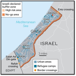
Gaza Strip / गाजा पट्टी
Syllabus : Prelims : Location In News
- The Gaza Strip is a self-governing Palestinian territory located on the eastern coast of the Mediterranean Sea.
- The territory takes its name from Gaza, its main city.
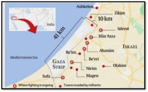
- It forms the smaller of the two Palestinian territories — the other being the West Bank.
- Bordering Countries: It is bordered by Israel to the north and east and Egypt to the south.
- Size: It is a 41km (25-mile) long and 10km-wide territory.
- Climate: It has a temperate climate, with mild winters, and dry, hot summer.
- Population:
- It is one of the most densely populated areas globally, with over 2 million residents living in a tiny area.
- The term “open air prison” has been widely used by academics, activists, and journalists to characterize the conditions in Gaza.
- The population is predominantly Palestinian, with the majority being Sunni Muslims.
History:
- After Israel declared its statehood in 1948, Egypt controlled the Gaza Strip for nearly two decades Israel then gained control of the Gaza Strip and the West Bank after its victory in the 1967 Six-Day War against its Arab neighbours.
- For the next 38 years, Israel controlled thestrip and enabled the construction of 21 Jewish settlements.
- In 2005, under international and domestic pressure, Israel withdrew around 9,000 Israeli settlers and its military forces from the Gaza Strip, leaving the enclave to be governed by the internationally recognised Palestinian Authority, which also controlled parts of the occupied West Bank.
Who controls it now?
- Hamas, a Palestinian Islamist organisation, currently governs the Gaza Strip.
- It took control in 2007after it won elections there the year before. Since then, no elections have been held.
- Hamas, unlike the Palestinian Authority, doesn’t recognize Israel’s right to exist.
- Israel has maintained a land, air and sea blockade on Gaza since 2007.
गाजा पट्टी
- गाजा पट्टी भूमध्य सागर के पूर्वी तट पर स्थित एक स्वशासित फिलिस्तीनी क्षेत्र है।
- इस क्षेत्र का नाम इसके मुख्य शहर गाजा से लिया गया है।
- यह दो फिलिस्तीनी क्षेत्रों में से एक छोटा क्षेत्र है – दूसरा पश्चिमी तट है।
- सीमावर्ती देश: यह उत्तर और पूर्व में इज़राइल और दक्षिण में मिस्र से घिरा है।
- आकार: यह 41 किमी (25 मील) लंबा और 10 किमी चौड़ा क्षेत्र है।
- जलवायु: इसकी जलवायु समशीतोष्ण है, हल्की सर्दियाँ और शुष्क, गर्म ग्रीष्मकाल।
जनसंख्या:
- यह दुनिया भर में सबसे घनी आबादी वाले क्षेत्रों में से एक है, जहाँ 2 मिलियन से अधिक निवासी एक छोटे से क्षेत्र में रहते हैं।
- “खुली हवा वाली जेल” शब्द का इस्तेमाल शिक्षाविदों, कार्यकर्ताओं और पत्रकारों द्वारा गाजा की स्थितियों को दर्शाने के लिए व्यापक रूप से किया गया है।
- जनसंख्या मुख्य रूप से फिलिस्तीनी है, जिसमें अधिकांश सुन्नी मुसलमान हैं।
इतिहास:
- 1948 में इज़राइल द्वारा अपना राज्य घोषित करने के बाद, मिस्र ने लगभग दो दशकों तक गाजा पट्टी को नियंत्रित किया। इज़राइल ने अपने अरब पड़ोसियों के खिलाफ 1967 के छह दिवसीय युद्ध में जीत के बाद गाजा पट्टी और पश्चिमी तट पर नियंत्रण हासिल कर लिया।
- अगले 38 वर्षों तक, इज़राइल ने इस पट्टी को नियंत्रित किया और 21 यहूदी बस्तियों के निर्माण को सक्षम बनाया।
- 2005 में, अंतर्राष्ट्रीय और घरेलू दबाव के तहत, इज़राइल ने गाजा पट्टी से लगभग 9,000 इज़राइली बसने वालों और अपने सैन्य बलों को वापस ले लिया, जिससे इस क्षेत्र को अंतर्राष्ट्रीय स्तर पर मान्यता प्राप्त फिलिस्तीनी प्राधिकरण द्वारा शासित किया गया, जिसने कब्जे वाले वेस्ट बैंक के कुछ हिस्सों को भी नियंत्रित किया।
अब इसे कौन नियंत्रित करता है?
- हमास, एक फिलिस्तीनी इस्लामवादी संगठन, वर्तमान में गाजा पट्टी पर शासन करता है।
- इसने 2007 में चुनाव जीतने के बाद नियंत्रण हासिल किया। तब से, कोई चुनाव नहीं हुआ है।
- हमास, फिलिस्तीनी प्राधिकरण के विपरीत, इज़राइल के अस्तित्व के अधिकार को मान्यता नहीं देता है।
- इज़राइल ने 2007 से गाजा पर भूमि, वायु और समुद्री नाकाबंदी बनाए रखी है।
Heat-baked Chennai can set an example for India / गर्मी से तपता चेन्नई भारत के लिए एक मिसाल बन सकता है
(General Studies- Paper I & III)
Source : The Hindu
Context
- This article discusses the exacerbation of heatwaves in urban areas, particularly Chennai, due to the Urban Heat Island (UHI) effect.
- It outlines the impact of rising temperatures, existing response measures, and proposes solutions including green spaces and energy-efficient cooling technologies.
Overview of Climate Change Impact:
- The year 2023 witnessed record-breaking temperatures, with global averages surpassing pre-industrial levels by 1.45°C, nearing the 1.5°C limit established in the Paris Agreement.
- Scientists predict a continuation of such extreme heat trends in 2024, exacerbating climate impacts, particularly evident in the Indian subcontinent with escalating heatwaves.
The reality of the urban heat island
- Urban Heat Island (UHI) effect aggravates temperature disparities in cities, where densely populated areas experience temperatures several degrees higher than surrounding rural regions.
- Concrete structures and asphalt roads absorb and retain heat, exacerbating the heat bubble within urban areas, exacerbated by air pollution and the absence of green spaces.
- Coastal cities like Chennai face additional challenges due to high humidity, diminishing the body’s natural cooling mechanisms, and escalating heat-related health risks.
Case study of Chennai
- Chennai, a coastal city, is affected by yet another feature which is cause for worry.
- Humidity reduces the cooling effect of perspiration, leading to a person experiencing an elevated body temperature, debilitating heat stress, exhaustion, and even a potentially fatal heat stroke.
- The UHI in Chennai adds between 2° to 4° C to temperatures in nearby rural areas. So, when the maximum temperature is 40° C elsewhere, parts of Chennai could register between 42° to 44° C.
- Under high humidity conditions, wet-bulb temperature (indicating the extent to which evaporation can take place and facilitate cooling) of around 38.5° C is considered by the World Health Organization to be “near the limits of human survivability”.
- In India, a heatwave is officially declared in coastal areas when the maximum temperatures are over 37° C and 4.5° C above normal.
- Clearly, with an UHI, heatwave conditions are quite easily breached in Chennai. The effects could be much worse, even dangerous, when compared to inland, rural areas.
Initiatives of the government
- India has national, State and even some district-level Heat Action Plans (HAP) to reduce morbidity and mortality, especially among the vulnerable poor, infants and the elderly.
- The National Disaster Management Authority (NDMA) Guidelines, which are being upgraded, and those of several States, outline measures to deal with heatwaves including early warning bulletins, and staggered work hours at outdoor construction sites, with shaded areas and temporary shelters, and strategic provisioning of drinking water and oral rehydration salts.
Urban Heat Islands
- Urban heat islands (UHIs) are localized areas within urban environments that experience significantly higher temperatures compared to their surrounding rural areas.
- UHIs occur due to human activities, modifications to the landscape, and the concentration of heat-absorbing materials in urban settings. They are a result of the urbanization process and can have various impacts on the environment, public health, and energy consumption.
- The phenomenon, ‘Urban Heat Island’ was first investigated and described by Luke Howard in the 1810s.
Causes for the formation of heat islands
- Heat islands form in urban and suburban areas because many common construction materials absorb and retain more of the sun’s heat than natural materials in less developed rural areas.
- Temperatures of dark, dry surfaces in direct sun can reach 88°C during the day, while vegetated surfaces with moist soil under the same conditions might reach only 18°C.
- Concrete, cement, and metal surfaces in urban areas tend to absorb heat energy rather than reflect it, contributing to higher urban temperatures.
- Cities have a low albedo, the reflecting power of a surface. The increased surface area of buildings results in more solar radiation absorption than reflection.
- Heat Absorbing Materials: Urban areas are characterized by extensive use of heat-absorbing materials such as asphalt, concrete, and dark-colored buildings. These materials absorb and retain solar radiation, leading to elevated temperatures.
- Reduced Vegetation: Urbanization often involves the removal of natural vegetation, such as trees and green spaces, which act as cooling agents through evapotranspiration and shading.
- Human Activities: Heat generated by human activities, including industrial processes, vehicular traffic, and energy consumption, contributes to the overall temperature increase in urban areas.
- Artificial Heat Sources: The presence of heat sources like air conditioners, industrial processes, and waste heat from buildings and vehicles further exacerbates this.
- Modified Wind Patterns: Urban landscapes can alter local wind patterns, reducing natural ventilation and trapping warm air within the city.
- Urban Form: The density, layout, and design of urban areas can impact the intensity and extent of UHIs. High-rise buildings, narrow streets, and compact urban layouts can intensify heat retention.
Impacts of urban heat islands
- UHIs lead to higher demand for cooling in buildings, increasing energy consumption, and associated greenhouse gas emissions.
- Elevated temperatures in urban areas can cause heat-related illnesses and exacerbate existing health conditions, particularly in vulnerable populations.
- UHIs can contribute to poor air quality, as higher temperatures can enhance the formation of ground-level ozone and other air pollutants.
- UHIs affect the water balance in urban areas, leading to increased runoff and reduced infiltration, affecting stormwater management.
- UHIs can disrupt local ecosystems, impacting flora and fauna and altering natural habitats.
Remedies
- Urban Planning: Incorporating green spaces, parks, and trees into urban planning can help mitigate UHIs by providing shading and promoting natural cooling.
- Cool Roofs and Pavements: Implementing cool roofs and pavements, which reflect sunlight rather than absorb it, can reduce heat absorption in urban areas.
- Green Roof and Walls: Installing green roofs and walls can help reduce surface temperatures and improve air quality.
- Energy-Efficient Buildings: Promoting energy-efficient building designs and cool building materials can reduce heat emissions from structures.
- Transportation Planning: Encouraging public transportation, biking, and walking can help reduce vehicular heat emissions.
- By implementing these strategies, cities can effectively mitigate urban heat islands and create more comfortable and sustainable living environments for their residents.
Way forward
- Cooler, shaded spaces in our parks, near buildings, in streetscapes, and alongside homes can reduce heat stress, particularly for those in our community who are most vulnerable to high temperatures.
- Note: Cities in desert environments show a different trend known as the “urban oasis effect”. This effect is characterized by a cooler city center compared to the surrounding environments
गर्मी से तपता चेन्नई भारत के लिए एक मिसाल बन सकता है
प्रसंग:
- यह लेख शहरी क्षेत्रों, विशेष रूप से चेन्नई में शहरी ताप द्वीप (UHI) प्रभाव के कारण गर्मी की लहरों के बढ़ने पर चर्चा करता है।
- यह बढ़ते तापमान के प्रभाव, मौजूदा प्रतिक्रिया उपायों की रूपरेखा प्रस्तुत करता है, तथा हरित स्थानों और ऊर्जा-कुशल शीतलन प्रौद्योगिकियों सहित समाधान प्रस्तावित करता है।
जलवायु परिवर्तन प्रभाव का अवलोकन:
- वर्ष 2023 में रिकॉर्ड तोड़ तापमान देखा गया, वैश्विक औसत 45°C से पूर्व-औद्योगिक स्तरों को पार कर गया, जो पेरिस समझौते में स्थापित 1.5°C सीमा के करीब है।
- वैज्ञानिकों का अनुमान है कि 2024 में भी इस तरह की अत्यधिक गर्मी की प्रवृत्ति जारी रहेगी, जिससे जलवायु प्रभाव और बढ़ेंगे, विशेष रूप से भारतीय उपमहाद्वीप में बढ़ती गर्मी के साथ।
शहरी ताप द्वीप की वास्तविकता:
- शहरी ताप द्वीप (UHI) प्रभाव शहरों में तापमान असमानताओं को बढ़ाता है, जहाँ घनी आबादी वाले क्षेत्रों में आसपास के ग्रामीण क्षेत्रों की तुलना में कई डिग्री अधिक तापमान होता है।
- कंक्रीट की संरचनाएँ और डामर की सड़कें गर्मी को अवशोषित करती हैं और बनाए रखती हैं, जिससे शहरी क्षेत्रों में गर्मी का बुलबुला बढ़ता है, जो वायु प्रदूषण और हरित स्थानों की अनुपस्थिति से और भी बढ़ जाता है।
- चेन्नई जैसे तटीय शहरों में उच्च आर्द्रता, शरीर के प्राकृतिक शीतलन तंत्र को कम करने और गर्मी से संबंधित स्वास्थ्य जोखिमों में वृद्धि के कारण अतिरिक्त चुनौतियों का सामना करना पड़ता है।
चेन्नई का केस स्टडी
- चेन्नई, एक तटीय शहर, एक और विशेषता से प्रभावित है जो चिंता का कारण है।
- नमी पसीने के शीतलन प्रभाव को कम करती है, जिससे व्यक्ति को शरीर का तापमान बढ़ जाता है, गर्मी से होने वाला तनाव, थकावट और यहां तक कि संभावित रूप से घातक हीट स्ट्रोक का अनुभव होता है।
- चेन्नई में यूएचआई आस-पास के ग्रामीण क्षेत्रों में तापमान में 2° से 4° सेल्सियस तक की वृद्धि करता है। इसलिए, जब कहीं और अधिकतम तापमान 40° सेल्सियस होता है, तो चेन्नई के कुछ हिस्सों में 42° से 44° सेल्सियस के बीच तापमान दर्ज किया जा सकता है।
- उच्च आर्द्रता की स्थिति में, 38.5° सेल्सियस के आसपास के वेट-बल्ब तापमान (यह दर्शाता है कि वाष्पीकरण किस हद तक हो सकता है और शीतलन की सुविधा प्रदान कर सकता है) को विश्व स्वास्थ्य संगठन द्वारा “मानव जीवित रहने की सीमा के करीब” माना जाता है।
- भारत में, तटीय क्षेत्रों में आधिकारिक तौर पर हीटवेव की घोषणा तब की जाती है जब अधिकतम तापमान 37 डिग्री सेल्सियस से अधिक और सामान्य से 5 डिग्री सेल्सियस अधिक होता है।
- स्पष्ट रूप से, यूएचआई के साथ, चेन्नई में हीटवेव की स्थिति का आसानी से उल्लंघन किया जा सकता है। अंतर्देशीय, ग्रामीण क्षेत्रों की तुलना में इसके प्रभाव बहुत अधिक खराब, यहां तक कि खतरनाक भी हो सकते हैं।
सरकार की पहल
- भारत में राष्ट्रीय, राज्य और यहां तक कि कुछ जिला-स्तरीय हीट एक्शन प्लान (HAP) हैं, ताकि विशेष रूप से कमजोर गरीबों, शिशुओं और बुजुर्गों के बीच रुग्णता और मृत्यु दर को कम किया जा सके।
- राष्ट्रीय आपदा प्रबंधन प्राधिकरण (NDMA) के दिशा-निर्देश, जिन्हें अपग्रेड किया जा रहा है, और कई राज्यों के दिशा-निर्देश, हीटवेव से निपटने के उपायों की रूपरेखा तैयार करते हैं, जिसमें प्रारंभिक चेतावनी बुलेटिन, और बाहरी निर्माण स्थलों पर काम के घंटों में अंतर, छायादार क्षेत्र और अस्थायी आश्रय, और पीने के पानी और ओरल रिहाइड्रेशन लवणों की रणनीतिक व्यवस्था शामिल है।
शहरी हीट आइलैंड्स
- शहरी हीट आइलैंड्स (UHI) शहरी वातावरण के भीतर स्थानीयकृत क्षेत्र हैं जो अपने आसपास के ग्रामीण क्षेत्रों की तुलना में काफी अधिक तापमान का अनुभव करते हैं।
- यूएचआई मानवीय गतिविधियों, परिदृश्य में संशोधन और शहरी परिवेश में ऊष्मा-अवशोषित करने वाली सामग्रियों की सांद्रता के कारण होते हैं। वे शहरीकरण प्रक्रिया का परिणाम हैं और पर्यावरण, सार्वजनिक स्वास्थ्य और ऊर्जा खपत पर विभिन्न प्रभाव डाल सकते हैं।
- ‘शहरी ऊष्मा द्वीप’ नामक घटना की पहली बार 1810 के दशक में ल्यूक हॉवर्ड ने जांच की और उसका वर्णन किया।
ऊष्मा द्वीप बनने के कारण
- शहरी और उपनगरीय क्षेत्रों में ऊष्मा द्वीप बनते हैं क्योंकि कई सामान्य निर्माण सामग्री कम विकसित ग्रामीण क्षेत्रों में प्राकृतिक सामग्रियों की तुलना में सूर्य की गर्मी को अधिक अवशोषित और बनाए रखती हैं।
- सीधे सूर्य के प्रकाश में अंधेरे, शुष्क सतहों का तापमान दिन के दौरान 88 डिग्री सेल्सियस तक पहुँच सकता है, जबकि समान परिस्थितियों में नम मिट्टी वाली वनस्पति सतहें केवल 18 डिग्री सेल्सियस तक पहुँच सकती हैं।
- शहरी क्षेत्रों में कंक्रीट, सीमेंट और धातु की सतहें ऊष्मा ऊर्जा को परावर्तित करने के बजाय अवशोषित करती हैं, जिससे शहरी तापमान में वृद्धि होती है।
- शहरों में सतह की परावर्तक शक्ति, एल्बेडो कम होती है। इमारतों के बढ़े हुए सतही क्षेत्र के परिणामस्वरूप परावर्तन की तुलना में अधिक सौर विकिरण अवशोषण होता है।
- गर्मी अवशोषित करने वाली सामग्री: शहरी क्षेत्रों में डामर, कंक्रीट और गहरे रंग की इमारतों जैसी गर्मी अवशोषित करने वाली सामग्रियों का व्यापक उपयोग होता है। ये सामग्रियाँ सौर विकिरण को अवशोषित करती हैं और बनाए रखती हैं, जिससे तापमान बढ़ जाता है।
- वनस्पति में कमी: शहरीकरण में अक्सर प्राकृतिक वनस्पतियों को हटाना शामिल होता है, जैसे कि पेड़ और हरे भरे स्थान, जो वाष्पोत्सर्जन और छाया के माध्यम से शीतलन एजेंट के रूप में कार्य करते हैं।
- मानवीय गतिविधियाँ: औद्योगिक प्रक्रियाओं, वाहनों के आवागमन और ऊर्जा खपत सहित मानवीय गतिविधियों से उत्पन्न गर्मी शहरी क्षेत्रों में समग्र तापमान वृद्धि में योगदान करती है।
- कृत्रिम ऊष्मा स्रोत: एयर कंडीशनर, औद्योगिक प्रक्रियाओं और इमारतों और वाहनों से निकलने वाली अपशिष्ट ऊष्मा जैसे ऊष्मा स्रोतों की उपस्थिति इसे और बढ़ा देती है।
- संशोधित पवन पैटर्न: शहरी परिदृश्य स्थानीय पवन पैटर्न को बदल सकते हैं, जिससे प्राकृतिक वेंटिलेशन कम हो सकता है और शहर के भीतर गर्म हवा फंस सकती है।
- शहरी रूप: शहरी क्षेत्रों का घनत्व, लेआउट और डिज़ाइन UHI की तीव्रता और सीमा को प्रभावित कर सकता है। ऊँची इमारतें, संकरी गलियाँ और कॉम्पैक्ट शहरी लेआउट गर्मी को बनाए रखने में तेज़ी ला सकते हैं।
शहरी ताप द्वीपों के प्रभाव
- UHI के कारण इमारतों में ठंडक की माँग बढ़ जाती है, ऊर्जा की खपत बढ़ जाती है और ग्रीनहाउस गैस उत्सर्जन बढ़ जाता है।
- शहरी क्षेत्रों में उच्च तापमान गर्मी से संबंधित बीमारियों का कारण बन सकता है और मौजूदा स्वास्थ्य स्थितियों को बढ़ा सकता है, खासकर कमज़ोर आबादी में।
- UHI खराब वायु गुणवत्ता में योगदान दे सकता है, क्योंकि उच्च तापमान ग्राउंड-लेवल ओजोन और अन्य वायु प्रदूषकों के निर्माण को बढ़ा सकता है।
- UHI शहरी क्षेत्रों में जल संतुलन को प्रभावित करते हैं, जिससे अपवाह बढ़ता है और घुसपैठ कम होती है, जिससे तूफानी जल प्रबंधन प्रभावित होता है।
- UHI स्थानीय पारिस्थितिकी तंत्र को बाधित कर सकते हैं, वनस्पतियों और जीवों को प्रभावित कर सकते हैं और प्राकृतिक आवासों को बदल सकते हैं।
उपाय
- शहरी नियोजन: शहरी नियोजन में हरित स्थान, पार्क और पेड़ों को शामिल करने से छाया प्रदान करके और प्राकृतिक शीतलन को बढ़ावा देकर यूएचआई को कम करने में मदद मिल सकती है।
- ठंडी छतें और फुटपाथ: ठंडी छतों और फुटपाथों को लागू करना, जो सूर्य के प्रकाश को अवशोषित करने के बजाय परावर्तित करते हैं, शहरी क्षेत्रों में गर्मी के अवशोषण को कम कर सकते हैं।
- हरित छत और दीवारें: हरित छत और दीवारें लगाने से सतह के तापमान को कम करने और वायु की गुणवत्ता में सुधार करने में मदद मिल सकती है।
- ऊर्जा-कुशल इमारतें: ऊर्जा-कुशल भवन डिजाइन और ठंडी निर्माण सामग्री को बढ़ावा देने से संरचनाओं से गर्मी उत्सर्जन कम हो सकता है।
- परिवहन योजना: सार्वजनिक परिवहन, बाइकिंग और पैदल चलने को प्रोत्साहित करने से वाहनों से होने वाले गर्मी उत्सर्जन को कम करने में मदद मिल सकती है।
- इन रणनीतियों को लागू करके, शहर प्रभावी रूप से शहरी गर्मी द्वीपों को कम कर सकते हैं और अपने निवासियों के लिए अधिक आरामदायक और टिकाऊ रहने का वातावरण बना सकते हैं।
आगे की राह
- हमारे पार्कों में, इमारतों के पास, सड़कों के किनारे और घरों के साथ ठंडी, छायादार जगहें गर्मी के तनाव को कम कर सकती हैं, खासकर हमारे समुदाय के उन लोगों के लिए जो उच्च तापमान के प्रति सबसे अधिक संवेदनशील हैं।
नोट: रेगिस्तानी वातावरण वाले शहर एक अलग प्रवृत्ति दिखाते हैं जिसे “शहरी नखलिस्तान प्रभाव” के रूप में जाना जाता है। इस प्रभाव की विशेषता यह है कि आसपास के वातावरण की तुलना में शहर का केंद्र अधिक ठंडा रहता है।
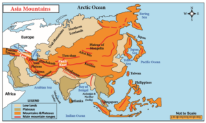
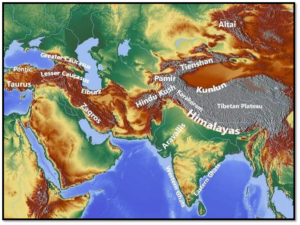
Major Physical Divisions of Asia [Mapping] / एशिया के प्रमुख भौतिक विभाग [मानचित्र]
Major Physical Divisions of Asia
- The Northern Lowlands
- The Central Mountains
- The Central and Southern Plateaus
- The Peninsulas
- Deserts
- The Great River Plains
- Island Groups
- The Northern Lowlands
- The Northern Lowlands are the extensive plain areas that comprise of several patches of lowlands of this large continent.
The major lowlands are:
-
- Great Siberian plain: It extends between the Ural Mountains in the west and the river Lena in the east. It is the largest lowland in the world covering an area of 1,200,000 square miles approx.
Manchurian Plain
- It is the area adjoining Amur river and its tributaries of the northern part of China with an area of 135,000 square miles approx.

Great Plains of China
- It is contributed by two major rivers of China, Hwang Ho and Yangtze river which covers an area of 158,000 square miles approx.

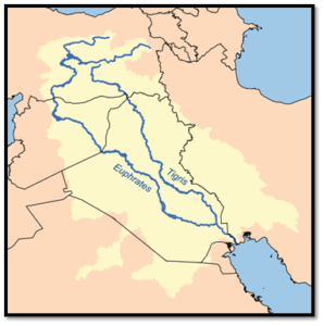
Tigris-Euphrates plains
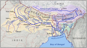
Ganga plains
Irrawaddy plains

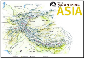
- The Central Mountains
- These are the prominent and extensive mountain ranges that cover the parts of Central Asia.
- They consist of Pamir and Tian Shan ranges and extending across portions of Afghanistan, China, Kazakhstan, Kyrgyzstan, Tajikistan, and Uzbekistan.
- These mountain ranges are designated as biodiversity hot spots by Conservation International which covers several montanes and alpine ecoregions of Central Asia.
- It encompasses several habitat types, including montane grasslands and shrublands, temperate coniferous forests, and alpine tundra.
- A mountain knot is a junction of two or more mountain ranges. The two main mountain knots in Asia are:
- The Pamir Knot is the junction of five mountain ranges they are the Sulaiman, the Hindu Kush, the Kunlun, the Karakoram, and the Himalayan ranges. Mount Everest, the highest peak in the world in the Himalayan range.
- The Armenian Knot is connected to the Pamir Knot by the Elburz and the Zagros Ranges that originate in the Armenian Knot. The Tien Shan and the Altai are other mountain ranges in Asia.
Peaks of Asia
- Mount Everest (8848 m), Nepal-Tibet, China border
- K2 (8,61,1 m), (POK) India -China
- Kangchenjunga (8,586 m), Nepal-Sikkim (India).
- Lhotse (8,516 m), Nepal-Tibet, China
- Makalu (8,462 m), Nepal-Tibet, China
- Cho Oyu (8,201 m), Nepal
एशिया के प्रमुख भौतिक विभाग [मानचित्र]
एशिया के प्रमुख भौतिक प्रभाग
- उत्तरी तराई
- मध्य पर्वत
- मध्य और दक्षिणी पठार
- प्रायद्वीप
- रेगिस्तान
- महान नदी मैदान
- द्वीप समूह
- उत्तरी तराई
- उत्तरी तराई क्षेत्र विस्तृत मैदानी क्षेत्र हैं, जिनमें इस विशाल महाद्वीप के कई निचले क्षेत्र शामिल हैं।
प्रमुख तराई क्षेत्र हैं:
- ग्रेट साइबेरियन मैदान: यह पश्चिम में यूराल पर्वत और पूर्व में लीना नदी के बीच फैला हुआ है। यह दुनिया का सबसे बड़ा निचला क्षेत्र है, जो लगभग 1,200,000 वर्ग मील के क्षेत्र को कवर करता है।
मंचूरियन मैदान
यह चीन के उत्तरी भाग में अमूर नदी और उसकी सहायक नदियों से सटा हुआ क्षेत्र है जिसका क्षेत्रफल लगभग 135,000 वर्ग मील है।
चीन के महान मैदान
इसमें चीन की दो प्रमुख नदियाँ, ह्वांग हो और यांग्त्ज़ी नदी शामिल हैं, जो लगभग 158,000 वर्ग मील के क्षेत्र को कवर करती हैं।
टिगरिस-फरात मैदान
गंगा के मैदान
इरावदी के मैदान
- मध्य पर्वत
- ये प्रमुख और विस्तृत पर्वत श्रृंखलाएँ हैं जो मध्य एशिया के भागों को कवर करती हैं।
- इनमें पामीर और तियान शान पर्वतमालाएँ शामिल हैं और ये अफ़गानिस्तान, चीन, कज़ाकिस्तान, किर्गिस्तान, ताजिकिस्तान और उज़बेकिस्तान के कुछ हिस्सों में फैली हुई हैं।
- इन पर्वत श्रृंखलाओं को कंज़र्वेशन इंटरनेशनल द्वारा जैव विविधता हॉट स्पॉट के रूप में नामित किया गया है जो मध्य एशिया के कई पर्वतीय और अल्पाइन पारिस्थितिकी क्षेत्रों को कवर करती हैं।
- इसमें कई प्रकार के आवास शामिल हैं, जिनमें पर्वतीय घास के मैदान और झाड़ियाँ, समशीतोष्ण शंकुधारी वन और अल्पाइन टुंड्रा शामिल हैं।
- एक पर्वत गाँठ दो या अधिक पर्वत श्रृंखलाओं का जंक्शन है। एशिया में दो मुख्य पर्वत गाँठें हैं:
- पामीर गाँठ पाँच पर्वत श्रृंखलाओं का जंक्शन है वे सुलेमान, हिंदू कुश, कुनलुन, कराकोरम और हिमालय पर्वतमाला हैं। माउंट एवरेस्ट, हिमालय पर्वतमाला में दुनिया की सबसे ऊँची चोटी है।
- अर्मेनियाई नॉट एल्बुर्ज और ज़ाग्रोस पर्वतमाला द्वारा पामीर नॉट से जुड़ा हुआ है, जो अर्मेनियाई नॉट से निकलती हैं। टीएन शान और अल्ताई एशिया की अन्य पर्वत श्रृंखलाएँ हैं।
एशिया की चोटियाँ
- माउंट एवरेस्ट (8848 मीटर), नेपाल-तिब्बत, चीन सीमा
- K2 (8,61,1 मीटर), (POK) भारत-चीन
- कंचनजंगा (8,586 मीटर), नेपाल-सिक्किम (भारत)।
- लोत्से (8,516 मीटर), नेपाल-तिब्बत, चीन
- मकालू (8,462 मीटर), नेपाल-तिब्बत, चीन
- चो ओयू (8,201 मीटर), नेपाल