CURRENT AFFAIRS – 27/06/2024
- CURRENT AFFAIRS – 27/06/2024
- U.S. criticises India in report on religious freedom / धार्मिक स्वतंत्रता पर रिपोर्ट में अमेरिका ने भारत की आलोचना की
- India’s largest leopard safari opens at Bannerghatta / भारत की सबसे बड़ी तेंदुआ सफारी बन्नेरघट्टा में खुली
- Prolonged exposure to coal mining causes respiratory, skin diseases in workers : study / कोयला खनन के कारण लंबे समय तक काम करने से श्रमिकों में श्वसन और त्वचा संबंधी बीमारियां होती हैं: अध्ययन
- ‘Multi-omics’ is transforming how India spots and treats TB, cancers / ‘मल्टी-ओमिक्स’ भारत में टीबी और कैंसर की पहचान और उपचार के तरीके को बदल रहा है
- How well is India tapping its rooftop solar potential / भारत अपनी छत पर सौर ऊर्जा की क्षमता का कितना बेहतर उपयोग कर रहा है
- Read the rocks to improve India’s geological literacy / भारत की भूवैज्ञानिक साक्षरता को बेहतर बनाने के लिए चट्टानों को पढ़ें
- Major Physical Divisions of India : The Peninsular Plateau : Part 2 [Mapping] / भारत के प्रमुख भौतिक विभाग: प्रायद्वीपीय पठार: भाग 2 [मानचित्र]
CURRENT AFFAIRS – 27/06/2024
U.S. criticises India in report on religious freedom / धार्मिक स्वतंत्रता पर रिपोर्ट में अमेरिका ने भारत की आलोचना की
(General Studies- Paper II)
Source : The Hindu
The U.S. published a report on Wednesday criticizing India, a close partner, on religious freedom.
- Secretary of State Antony Blinken highlighted concerns about anti-conversion laws, hate speech, and demolition of homes and places of worship affecting minority faith communities in India.
- The report also noted a sharp increase in anti-Semitism and Islamophobia in the U.S. related to the Gaza war.
- Despite public criticism, significant action from the State Department against India is not anticipated in the upcoming annual religious freedom blacklist.
- The report raised concerns about Pakistan’s blasphemy laws, which foster intolerance and can incite vigilantism and mob violence.
- Blinken mentioned a dramatic rise in hate crimes against Muslims and Jews in the U.S.
- Nine European nations were noted for effectively banning some forms of religious clothing in public spaces, with France leading restrictions on full-face veils worn by Muslim women.
धार्मिक स्वतंत्रता पर रिपोर्ट में अमेरिका ने भारत की आलोचना की
अमेरिका ने बुधवार को धार्मिक स्वतंत्रता पर अपने करीबी सहयोगी भारत की आलोचना करते हुए एक रिपोर्ट प्रकाशित की।
- विदेश मंत्री एंटनी ब्लिंकन ने भारत में अल्पसंख्यक धार्मिक समुदायों को प्रभावित करने वाले धर्मांतरण विरोधी कानूनों, अभद्र भाषा और घरों तथा पूजा स्थलों को ध्वस्त करने के बारे में चिंताओं को उजागर किया।
- रिपोर्ट में गाजा युद्ध से संबंधित अमेरिका में यहूदी विरोधी भावना और इस्लामोफोबिया में तेज वृद्धि का भी उल्लेख किया गया है।
- सार्वजनिक आलोचना के बावजूद, आगामी वार्षिक धार्मिक स्वतंत्रता ब्लैकलिस्ट में भारत के खिलाफ विदेश विभाग की ओर से कोई महत्वपूर्ण कार्रवाई अपेक्षित नहीं है।
- रिपोर्ट में पाकिस्तान के ईशनिंदा कानूनों के बारे में चिंता जताई गई है, जो असहिष्णुता को बढ़ावा देते हैं और सतर्कता और भीड़ हिंसा को भड़का सकते हैं।
- ब्लिंकन ने अमेरिका में मुसलमानों और यहूदियों के खिलाफ घृणा अपराधों में नाटकीय वृद्धि का उल्लेख किया।
- नौ यूरोपीय देशों को सार्वजनिक स्थानों पर धार्मिक कपड़ों के कुछ रूपों पर प्रभावी रूप से प्रतिबंध लगाने के लिए जाना जाता है, जिसमें फ्रांस मुस्लिम महिलाओं द्वारा पहने जाने वाले पूरे चेहरे के नकाब पर प्रतिबंधों में सबसे आगे है।
India’s largest leopard safari opens at Bannerghatta / भारत की सबसे बड़ी तेंदुआ सफारी बन्नेरघट्टा में खुली
Syllabus : Prelims Fact
South India’s first and India’s largest leopard safari was inaugurated at Bannerghatta Biological Park, Karnataka.
- The safari aims to showcase leopards in a natural habitat while addressing human-animal conflict.
- The park also unveiled new facilities and proposed enclosures for various species, emphasising conservation and visitor education.
- The safari spans 20 hectares with eight leopards released in a natural forest setting.
- Costing ₹4.5 crore, the safari features rocky terrain and semi-deciduous forest with a 4.5-meter high chain-link mesh and MS sheets for safety.
- Aimed at highlighting leopards and addressing human-animal conflict, the park rescues leopard cubs for educational purposes.
- Additionally, new facilities include a renovated elephant weaning centre, babycare room, children’s play area, and electric buggies.
- Future plans involve naturalistic enclosures for emus, rheas, a cheetah enclosure, baboon enclosures, and a wolf enclosure, along with skywalks linking the zoo and butterfly park
भारत की सबसे बड़ी तेंदुआ सफारी बन्नेरघट्टा में खुली
दक्षिण भारत की पहली और भारत की सबसे बड़ी तेंदुआ सफारी का उद्घाटन कर्नाटक के बन्नेरघट्टा जैविक उद्यान में किया गया।
- सफारी का उद्देश्य तेंदुओं को प्राकृतिक आवास में दिखाना है, साथ ही मानव-पशु संघर्ष को संबोधित करना है।
- पार्क ने संरक्षण और आगंतुकों की शिक्षा पर जोर देते हुए विभिन्न प्रजातियों के लिए नई सुविधाओं और प्रस्तावित बाड़ों का भी अनावरण किया।
- सफारी 20 हेक्टेयर में फैली हुई है, जिसमें आठ तेंदुओं को प्राकृतिक वन सेटिंग में छोड़ा गया है।
- 5 करोड़ रुपये की लागत वाली इस सफारी में चट्टानी इलाका और अर्ध-पर्णपाती जंगल है, जिसमें सुरक्षा के लिए 4.5 मीटर ऊंची चेन-लिंक जाली और एमएस शीट हैं।
- तेंदुओं को उजागर करने और मानव-पशु संघर्ष को संबोधित करने के उद्देश्य से, पार्क शैक्षिक उद्देश्यों के लिए तेंदुए के शावकों को बचाता है।
- इसके अतिरिक्त, नई सुविधाओं में एक पुनर्निर्मित हाथी वीनिंग सेंटर, बेबीकेयर रूम, बच्चों का खेल क्षेत्र और इलेक्ट्रिक बग्गी शामिल हैं।
- भविष्य की योजनाओं में चिड़ियाघर और तितली पार्क को जोड़ने वाले स्काईवॉक के साथ-साथ एमू, रियास, चीता बाड़े, बबून बाड़े और भेड़िया बाड़े के लिए प्राकृतिक बाड़े शामिल हैं।
Prolonged exposure to coal mining causes respiratory, skin diseases in workers : study / कोयला खनन के कारण लंबे समय तक काम करने से श्रमिकों में श्वसन और त्वचा संबंधी बीमारियां होती हैं: अध्ययन
(General Studies- Paper II)
Source : The Hindu
A new study by the National Foundation of India (NFI) reveals that 75% of focus group participants have chronic respiratory and skin ailments due to prolonged exposure to coal mining pollutants.
- The study report titled, “At the Crossroads: Marginalised Communities and the Just Transition Dilemma”, is a sequel to the 2021 study by NFI on the socio-economic impact of coal transitions in India.
Key Highlights of the reports by the National Foundation for India:
- The study covered two districts each from three central Indian states—Chhattisgarh, Jharkhand, and Odisha surveying 1209 households and conducting 20 Focused Group Discussions (FDGs).
- Other key findings of the study are:
- Health Concerns: Prolonged exposure to coal mining pollutants has resulted in widespread respiratory and skin diseases among the local populations. At least 75% of participants in Focus Group Discussions (FGDs) reported issues such as chronic bronchitis, asthma, and various skin conditions.
- Economic Impact/ Economic Dependency on Coal: The phasing down of coal is expected to result in significant job losses and economic downturns in coal-dependent regions. This will not only impact the coal miners and workers directly but also the broader local economy.
- Caste-Based Inequities: Access to resources and opportunities is significantly skewed, with marginalized communities such as Scheduled Castes (SCs), Scheduled Tribes (STs), and Other Backward Classes (OBCs) being disproportionately affected.
- The report identifies several challenges in achieving a just transition, including the need to upskill a largely under-educated workforce and the lack of alternative livelihoods.
- It underscores the importance of community-specific policies, robust institutional mechanisms, and coordinated efforts between government bodies.
- The study offers a potential framework for safeguarding the interests of these communities through:
- Alternative Livelihoods: Emphasizing the development of new economic opportunities beyond coal.
- Ecological Restoration: Promoting environmental recovery to mitigate the health impacts of coal mining.
- Inclusive Policies: Ensuring that the transition policies are inclusive and consider the needs of marginalized communities.
Health risks associated with coal mine workers:
- Respiratory Issues: Coal mine workers are exposed to coal dust and silica, leading to respiratory conditions such as pneumoconiosis (black lung disease) and chronic obstructive pulmonary disease (COPD).
- Cardiovascular Problems: Long-term exposure to coal dust increases the risk of cardiovascular diseases, including hypertension and ischemic heart disease.
- Cancer Risk: Coal miners face higher risks of developing lung cancer due to exposure to carcinogenic substances like radon and diesel exhaust.
- Injuries and Accidents: Working in coal mines involves physical hazards such as falls, equipment accidents, and explosions, leading to injuries and fatalities.
- Mental Health Impacts: High-stress environments, isolation, and job insecurity contribute to mental health issues like anxiety and depression among coal mine workers.
कोयला खनन के कारण लंबे समय तक काम करने से श्रमिकों में श्वसन और त्वचा संबंधी बीमारियां होती हैं: अध्ययन
नेशनल फाउंडेशन ऑफ इंडिया (एनएफआई) द्वारा किए गए एक नए अध्ययन से पता चलता है कि फ़ोकस समूह के 75% प्रतिभागियों को कोयला खनन प्रदूषकों के लंबे समय तक संपर्क में रहने के कारण पुरानी श्वसन और त्वचा संबंधी बीमारियाँ हैं।
- “एट द क्रॉसरोड्स: मार्जिनलाइज्ड कम्युनिटीज़ एंड द जस्ट ट्रांज़िशन डिलेमा” शीर्षक वाली अध्ययन रिपोर्ट, भारत में कोयला संक्रमण के सामाजिक-आर्थिक प्रभाव पर एनएफआई द्वारा 2021 के अध्ययन की अगली कड़ी है।
नेशनल फाउंडेशन फॉर इंडिया की रिपोर्ट की मुख्य बातें:
- इस अध्ययन में तीन मध्य भारतीय राज्यों- छत्तीसगढ़, झारखंड और ओडिशा के दो-दो जिलों को शामिल किया गया, जिसमें 1209 घरों का सर्वेक्षण किया गया और 20 केंद्रित समूह चर्चाएँ (FDG) आयोजित की गईं।
अध्ययन के अन्य प्रमुख निष्कर्ष हैं:
-
- स्वास्थ्य संबंधी चिंताएँ: कोयला खनन प्रदूषकों के लंबे समय तक संपर्क में रहने के कारण स्थानीय आबादी में व्यापक श्वसन और त्वचा संबंधी बीमारियाँ फैल रही हैं। फोकस समूह चर्चाओं (FGD) में कम से कम 75% प्रतिभागियों ने क्रोनिक ब्रोंकाइटिस, अस्थमा और विभिन्न त्वचा संबंधी बीमारियों जैसी समस्याओं की सूचना दी।
- कोयले पर आर्थिक प्रभाव/आर्थिक निर्भरता: कोयले के उपयोग में कमी आने से कोयले पर निर्भर क्षेत्रों में बड़ी संख्या में नौकरियाँ खत्म होने और आर्थिक मंदी आने की आशंका है। इसका सीधा असर न केवल कोयला खनिकों और श्रमिकों पर पड़ेगा, बल्कि व्यापक स्थानीय अर्थव्यवस्था पर भी पड़ेगा।
- जाति-आधारित असमानताएँ: संसाधनों और अवसरों तक पहुँच में उल्लेखनीय विषमता है, अनुसूचित जाति (SC), अनुसूचित जनजाति (ST) और अन्य पिछड़ा वर्ग (OBC) जैसे हाशिए पर रहने वाले समुदाय असमान रूप से प्रभावित हैं।
- रिपोर्ट न्यायपूर्ण परिवर्तन को प्राप्त करने में कई चुनौतियों की पहचान करती है, जिसमें बड़े पैमाने पर कम शिक्षित कार्यबल को कुशल बनाने की आवश्यकता और वैकल्पिक आजीविका की कमी शामिल है।
- यह समुदाय-विशिष्ट नीतियों, मजबूत संस्थागत तंत्र और सरकारी निकायों के बीच समन्वित प्रयासों के महत्व को रेखांकित करता है।
- अध्ययन इन समुदायों के हितों की सुरक्षा के लिए एक संभावित रूपरेखा प्रस्तुत करता है:
- वैकल्पिक आजीविका: कोयले से परे नए आर्थिक अवसरों के विकास पर जोर देना।
- पारिस्थितिक बहाली: कोयला खनन के स्वास्थ्य प्रभावों को कम करने के लिए पर्यावरणीय सुधार को बढ़ावा देना।
- समावेशी नीतियाँ: यह सुनिश्चित करना कि परिवर्तन नीतियाँ समावेशी हों और हाशिए पर रहने वाले समुदायों की ज़रूरतों पर विचार करें।
कोयला खदान श्रमिकों से जुड़े स्वास्थ्य जोखिम:
- श्वसन संबंधी समस्याएं: कोयला खदान श्रमिक कोयले की धूल और सिलिका के संपर्क में आते हैं, जिससे न्यूमोकोनियोसिस (ब्लैक लंग डिजीज) और क्रॉनिक ऑब्सट्रक्टिव पल्मोनरी डिजीज (सीओपीडी) जैसी श्वसन संबंधी समस्याएं हो सकती हैं।
- हृदय संबंधी समस्याएं: कोयले की धूल के लंबे समय तक संपर्क में रहने से हृदय संबंधी बीमारियों का जोखिम बढ़ जाता है, जिसमें उच्च रक्तचाप और इस्केमिक हृदय रोग शामिल हैं।
- कैंसर का जोखिम: रेडॉन और डीजल निकास जैसे कार्सिनोजेनिक पदार्थों के संपर्क में आने के कारण कोयला खनिकों को फेफड़े के कैंसर के विकास के उच्च जोखिम का सामना करना पड़ता है।
- चोटें और दुर्घटनाएँ: कोयला खदानों में काम करने से गिरने, उपकरण दुर्घटनाओं और विस्फोटों जैसे शारीरिक खतरे शामिल होते हैं, जिससे चोट और मृत्यु होती है।
- मानसिक स्वास्थ्य प्रभाव: उच्च-तनाव वाले वातावरण, अलगाव और नौकरी की असुरक्षा कोयला खदान श्रमिकों के बीच चिंता और अवसाद जैसे मानसिक स्वास्थ्य मुद्दों में योगदान करती है।
‘Multi-omics’ is transforming how India spots and treats TB, cancers / ‘मल्टी-ओमिक्स’ भारत में टीबी और कैंसर की पहचान और उपचार के तरीके को बदल रहा है
(General Studies- Paper II)
Source : The Hindu
What is Multi-Omics Approach?
- The Multi-Omics Approach integrates data from multiple biological disciplines such as genomics, transcriptomics, proteomics, and epigenomics to comprehensively study biological systems.
- It aims to understand complex interactions among genes, proteins, and other molecules to unravel disease mechanisms, discover biomarkers, and develop personalised treatments in medicine and healthcare.
Advantages:
- Comprehensive Insights: Integrates data from genomics, transcriptomics, proteomics, and epigenomics to provide a holistic view of biological systems.
- Precision Medicine: Enables personalised treatment strategies tailored to individual genetic profiles, improving efficacy and reducing adverse effects.
- Understanding Disease Mechanisms: Unravels complex interactions between genes, proteins, and environmental factors underlying diseases.
- Biomarker Discovery: Identifies novel biomarkers for early disease detection, prognosis, and monitoring treatment response.
- Drug Discovery: Facilitates target identification and validation for developing new drugs and repurposing existing ones.
- Systems Biology: Enhances understanding of biological networks and pathways, aiding in modelling and predicting biological outcomes.
- Clinical Applications: Supports clinical trials by stratifying patients based on molecular subtypes for targeted therapies.
- Public Health Impact: Provides insights into population-specific variations in disease susceptibility and response to treatments.
‘मल्टी-ओमिक्स’ भारत में टीबी और कैंसर की पहचान और उपचार के तरीके को बदल रहा है
मल्टी-ओमिक्स दृष्टिकोण क्या है?
- मल्टी-ओमिक्स दृष्टिकोण जैविक प्रणालियों का व्यापक अध्ययन करने के लिए जीनोमिक्स, ट्रांसक्रिप्टोमिक्स, प्रोटिओमिक्स और एपिजेनोमिक्स जैसे कई जैविक विषयों से डेटा को एकीकृत करता है।
- इसका उद्देश्य रोग तंत्र को जानने, बायोमार्कर की खोज करने और चिकित्सा और स्वास्थ्य सेवा में व्यक्तिगत उपचार विकसित करने के लिए जीन, प्रोटीन और अन्य अणुओं के बीच जटिल अंतःक्रियाओं को समझना है।
लाभ:
- व्यापक अंतर्दृष्टि: जैविक प्रणालियों का समग्र दृष्टिकोण प्रदान करने के लिए जीनोमिक्स, ट्रांसक्रिप्टोमिक्स, प्रोटिओमिक्स और एपिजेनोमिक्स से डेटा को एकीकृत करता है।
- प्रिसिजन मेडिसिन: व्यक्तिगत आनुवंशिक प्रोफाइल के अनुरूप व्यक्तिगत उपचार रणनीतियों को सक्षम बनाता है, प्रभावकारिता में सुधार करता है और प्रतिकूल प्रभावों को कम करता है।
- रोग तंत्र को समझना: रोगों के अंतर्निहित जीन, प्रोटीन और पर्यावरणीय कारकों के बीच जटिल अंतःक्रियाओं को सुलझाता है।
- बायोमार्कर डिस्कवरी: रोग का शीघ्र पता लगाने, रोग का निदान करने और उपचार प्रतिक्रिया की निगरानी के लिए नए बायोमार्कर की पहचान करता है।
- ड्रग डिस्कवरी: नई दवाओं के विकास और मौजूदा दवाओं के पुन: उपयोग के लिए लक्ष्य पहचान और सत्यापन की सुविधा प्रदान करता है।
- सिस्टम बायोलॉजी: जैविक नेटवर्क और मार्गों की समझ को बढ़ाता है, जैविक परिणामों के मॉडलिंग और भविष्यवाणी में सहायता करता है।
- नैदानिक अनुप्रयोग: लक्षित उपचारों के लिए आणविक उपप्रकारों के आधार पर रोगियों को स्तरीकृत करके नैदानिक परीक्षणों का समर्थन करता है।
- सार्वजनिक स्वास्थ्य प्रभाव: रोग संवेदनशीलता और उपचारों के प्रति प्रतिक्रिया में जनसंख्या-विशिष्ट भिन्नताओं के बारे में जानकारी प्रदान करता है।
How well is India tapping its rooftop solar potential / भारत अपनी छत पर सौर ऊर्जा की क्षमता का कितना बेहतर उपयोग कर रहा है
(General Studies- Paper III)
Source : The Hindu
India’s rooftop solar capacity saw a substantial increase of 2.99 GW in 2023-2024, reaching 11.87 GW by March 2024.
- This growth reflects efforts under the Jawaharlal Nehru National Solar Mission, aiming for 100 GW solar capacity by 2026, with rooftop solar playing a crucial role in meeting renewable energy targets.
Rooftop Solar Systems:
- Benefits:
- Clean Energy: Reduces dependence on fossil fuels, leading to lower carbon emissions.
- Energy Security: Diversifies energy sources, reducing reliance on imports.
- Cost Savings: Lowers electricity bills over the long term, especially with rising grid tariffs.
- Job Creation: Stimulates employment in installation, maintenance, and related services.
- Grid Stability: Reduces strain on the grid during peak demand periods.
- Urban Space Utilisation: Uses idle rooftop space, promoting sustainable urban development.
- Challenges:
- Initial Costs: High upfront investment for installation and equipment.
- Policy and Regulatory Hurdles: Inconsistent policies across states and regulatory challenges.
- Technological Constraints: Variability in solar resource availability and storage limitations.
- Awareness and Education: Low consumer awareness about benefits and financing options.
- Integration Issues: Grid compatibility, net-metering policies, and interconnection challenges.
- Way Forward:
- Financial Incentives: Expand subsidies, tax breaks, and low-cost financing options.
- Streamlined Policies: Harmonise regulations across states, simplify approvals, and standardise tariffs.
- Technology Development: Invest in storage solutions, smart-grid integration, and efficiency improvements.
- Public Awareness Campaigns: Educate consumers about benefits, ROI, and environmental impacts.
- Capacity Building: Train workforce in solar technology, installation, and maintenance.
- Research and Development: Foster innovation in solar technologies, improving efficiency and cost-effectiveness.
भारत अपनी छत पर सौर ऊर्जा की क्षमता का कितना बेहतर उपयोग कर रहा है
भारत की छत पर सौर ऊर्जा क्षमता में 2023-2024 में 2.99 गीगावाट की उल्लेखनीय वृद्धि देखी गई, जो मार्च 2024 तक 11.87 गीगावाट तक पहुँच गई।
- यह वृद्धि जवाहरलाल नेहरू राष्ट्रीय सौर मिशन के तहत प्रयासों को दर्शाती है, जिसका लक्ष्य 2026 तक 100 गीगावाट सौर क्षमता हासिल करना है, जिसमें छत पर सौर ऊर्जा नवीकरणीय ऊर्जा लक्ष्यों को पूरा करने में महत्वपूर्ण भूमिका निभा रही है।
छत पर सौर प्रणाली:
- लाभ:
- स्वच्छ ऊर्जा: जीवाश्म ईंधन पर निर्भरता कम होती है, जिससे कार्बन उत्सर्जन कम होता है।
- ऊर्जा सुरक्षा: ऊर्जा स्रोतों में विविधता आती है, जिससे आयात पर निर्भरता कम होती है।
- लागत बचत: लंबी अवधि में बिजली के बिल कम होते हैं, खासकर ग्रिड टैरिफ बढ़ने के साथ।
- रोजगार सृजन: स्थापना, रखरखाव और संबंधित सेवाओं में रोजगार को बढ़ावा मिलता है।
- ग्रिड स्थिरता: पीक डिमांड अवधि के दौरान ग्रिड पर दबाव कम होता है।
- शहरी स्थान का उपयोग: छत पर खाली पड़ी जगह का उपयोग, टिकाऊ शहरी विकास को बढ़ावा देता है।
- चुनौतियाँ:
- प्रारंभिक लागत: स्थापना और उपकरणों के लिए उच्च अग्रिम निवेश।
- नीति और विनियामक बाधाएँ: राज्यों में असंगत नीतियाँ और विनियामक चुनौतियाँ।
- तकनीकी बाधाएँ: सौर संसाधन उपलब्धता और भंडारण सीमाओं में परिवर्तनशीलता।
- जागरूकता और शिक्षा: लाभों और वित्तपोषण विकल्पों के बारे में उपभोक्ताओं की कम जागरूकता।
- एकीकरण के मुद्दे: ग्रिड संगतता, नेट-मीटरिंग नीतियाँ और इंटरकनेक्शन चुनौतियाँ।
- आगे की राह:
- वित्तीय प्रोत्साहन: सब्सिडी, कर छूट और कम लागत वाले वित्तपोषण विकल्पों का विस्तार करें।
- सुव्यवस्थित नीतियाँ: राज्यों में विनियमनों में सामंजस्य स्थापित करें, अनुमोदन को सरल बनाएँ और टैरिफ को मानकीकृत करें।
- प्रौद्योगिकी विकास: भंडारण समाधान, स्मार्ट-ग्रिड एकीकरण और दक्षता में सुधार में निवेश करें।
- जन जागरूकता अभियान: उपभोक्ताओं को लाभ, ROI और पर्यावरणीय प्रभावों के बारे में शिक्षित करें।
- क्षमता निर्माण: सौर प्रौद्योगिकी, स्थापना और रखरखाव में कार्यबल को प्रशिक्षित करें।
- अनुसंधान और विकास: सौर प्रौद्योगिकियों में नवाचार को बढ़ावा दें, दक्षता और लागत-प्रभावशीलता में सुधार करें।
Read the rocks to improve India’s geological literacy / भारत की भूवैज्ञानिक साक्षरता को बेहतर बनाने के लिए चट्टानों को पढ़ें
(General Studies- Paper I)
Source : The Hindu
Context : India’s rich geological heritage, including diverse landscapes and significant fossil sites, faces threats from development and mining. Despite international conservation efforts, India lacks robust legislation to protect these geo-heritage sites. Effective conservation measures and dedicated legislation are crucial for preserving this non-cultural heritage for future generations.
Introduction
- India boasts a diverse geological morphology, ranging from towering peaks to coastal plains.
- The country is home to a variety of rocks, minerals, and distinctive fossil assemblages that reveal its geological history.
- These geological features are part of India’s non-cultural heritage and provide educational opportunities for geological literacy.
- Despite their significance, geological conservation in India has not gained much traction.
Geo-heritage and Conservation
- Geological conservation aims to preserve the best examples of India’s geological features and events for future generations.
- Many fossil-bearing sites have been destroyed due to development and real estate growth, as well as destructive stone mining activities.
- Stone-mining operations cover over 10% of India’s total area, posing a significant threat to geological features.
- Geological sites provide evidence of Earth’s history and evolutionary processes.
Importance of Geological Conservation
- Educational Value: Geo-heritage sites are educational spaces that help people understand geological processes and history.
- Examples include the Dhala meteoritic impact crater in Shivpuri, Madhya Pradesh, and the Lonar crater in Buldhana district, Maharashtra.
- The Dhala crater is evidence of a celestial collision dating back 1.5 to 2.5 billion years.
- The Lonar crater, previously thought to be 50,000 years old, is now estimated to be around 576,000 years old.
Global Recognition and Conservation Efforts
- The importance of geological heritage was first recognized at a UNESCO-sponsored event in 1991 in Digne, France.
- The event led to the establishment of geo-parks, which commemorate unique geological features and landscapes.
- Geo-parks also serve as educational spaces to raise public awareness about geological importance.
- Countries like Canada, China, Spain, the United States, and the United Kingdom have developed geo-heritage sites as national parks.
- UNESCO has prepared guidelines for the development of geo-parks, and many countries have enacted legislation for their protection.
Challenges in Geo-conservation in India:
Lack of Legal Framework
- Despite being a signatory to UNESCO’s guidelines, India lacks legislation or policy for geo-heritage conservation.
- The Geological Survey of India (GSI) has notified 34 geological monuments but lacks regulatory powers for preservation.
- The Varkala cliff in Kerala, a geological heritage site, faced destruction due to unauthorised structures and administrative decisions.
- This example highlights the need for robust legislation to protect geological heritage sites in India.
Global Progress and India’s Position:
- International Initiatives: UNESCO has prepared guidelines for geo-parks, with 169 Global Geoparks across 44 countries as of now.
- Legislative Measures: Many countries have implemented laws to conserve geological heritage, while India, despite being a signatory, lacks such legislation.
- Failed Attempts: The 2009 National Commission for Heritage Sites Bill and the 2022 Draft Geoheritage Sites and Geo-relics Bill have not progressed significantly.
Way Forward for India:
- Inventory Creation: Develop a comprehensive inventory of prospective geo-sites beyond the 34 identified by GSI.
- Legislative Action: Frame geo-conservation legislation similar to the Biological Diversity Act 2002.
- Institutional Framework: Establish a ‘National Geo-Conservation Authority’ with independent observers, ensuring autonomy for researchers and private collectors.
भारत की भूवैज्ञानिक साक्षरता को बेहतर बनाने के लिए चट्टानों को पढ़ें
प्रसंग : भारत की समृद्ध भूगर्भीय विरासत, जिसमें विविध परिदृश्य और महत्वपूर्ण जीवाश्म स्थल शामिल हैं, विकास और खनन से खतरे का सामना कर रही है। अंतर्राष्ट्रीय संरक्षण प्रयासों के बावजूद, भारत में इन भू-विरासत स्थलों की सुरक्षा के लिए मजबूत कानून का अभाव है। भावी पीढ़ियों के लिए इस गैर-सांस्कृतिक विरासत को संरक्षित करने के लिए प्रभावी संरक्षण उपाय और समर्पित कानून महत्वपूर्ण हैं।
परिचय
- भारत में विविध भूवैज्ञानिक आकृति विज्ञान है, जिसमें ऊंची चोटियों से लेकर तटीय मैदान तक शामिल हैं।
- देश में कई तरह की चट्टानें, खनिज और विशिष्ट जीवाश्म संयोजन हैं जो इसके भूवैज्ञानिक इतिहास को प्रकट करते हैं।
- ये भूवैज्ञानिक विशेषताएँ भारत की गैर-सांस्कृतिक विरासत का हिस्सा हैं और भूवैज्ञानिक साक्षरता के लिए शैक्षिक अवसर प्रदान करती हैं।
- अपने महत्व के बावजूद, भारत में भूवैज्ञानिक संरक्षण ने बहुत अधिक प्रगति नहीं की है।
भू-विरासत और संरक्षण
- भूवैज्ञानिक संरक्षण का उद्देश्य भविष्य की पीढ़ियों के लिए भारत की भूवैज्ञानिक विशेषताओं और घटनाओं के सर्वोत्तम उदाहरणों को संरक्षित करना है।
- विकास और रियल एस्टेट विकास के साथ-साथ विनाशकारी पत्थर खनन गतिविधियों के कारण कई जीवाश्म युक्त स्थल नष्ट हो गए हैं।
- पत्थर-खनन संचालन भारत के कुल क्षेत्रफल के 10% से अधिक क्षेत्र को कवर करता है, जो भूवैज्ञानिक विशेषताओं के लिए एक महत्वपूर्ण खतरा है।
- भूवैज्ञानिक स्थल पृथ्वी के इतिहास और विकासवादी प्रक्रियाओं के साक्ष्य प्रदान करते हैं।
भूवैज्ञानिक संरक्षण का महत्व
- शैक्षणिक मूल्य: भू-विरासत स्थल शैक्षिक स्थान हैं जो लोगों को भूवैज्ञानिक प्रक्रियाओं और इतिहास को समझने में मदद करते हैं।
- उदाहरणों में मध्य प्रदेश के शिवपुरी में ढाला उल्कापिंड प्रभाव गड्ढा और महाराष्ट्र के बुलढाणा जिले में लोनार गड्ढा शामिल हैं। ढाला गड्ढा 5 से 2.5 अरब साल पहले हुई खगोलीय टक्कर का सबूत है।
- लोनार गड्ढा, जिसे पहले 50,000 साल पुराना माना जाता था, अब लगभग 576,000 साल पुराना होने का अनुमान है।
वैश्विक मान्यता और संरक्षण प्रयास
- भूवैज्ञानिक विरासत के महत्व को पहली बार 1991 में फ्रांस के डिग्ने में यूनेस्को द्वारा प्रायोजित एक कार्यक्रम में पहचाना गया था।
- इस कार्यक्रम के परिणामस्वरूप भू-पार्कों की स्थापना हुई, जो अद्वितीय भूवैज्ञानिक विशेषताओं और परिदृश्यों का स्मरण करते हैं।
- भू-पार्क भूवैज्ञानिक महत्व के बारे में लोगों में जागरूकता बढ़ाने के लिए शैक्षिक स्थान के रूप में भी काम करते हैं।
- कनाडा, चीन, स्पेन, संयुक्त राज्य अमेरिका और यूनाइटेड किंगडम जैसे देशों ने भू-विरासत स्थलों को राष्ट्रीय उद्यानों के रूप में विकसित किया है।
- यूनेस्को ने भू-पार्कों के विकास के लिए दिशा-निर्देश तैयार किए हैं और कई देशों ने उनके संरक्षण के लिए कानून बनाए हैं।
भारत में भू-संरक्षण में चुनौतियाँ:
कानूनी ढाँचे का अभाव
- यूनेस्को के दिशा-निर्देशों पर हस्ताक्षर करने के बावजूद, भारत में भू-विरासत संरक्षण के लिए कानून या नीति का अभाव है।
- भारतीय भूवैज्ञानिक सर्वेक्षण (जीएसआई) ने 34 भूवैज्ञानिक स्मारकों को अधिसूचित किया है, लेकिन संरक्षण के लिए नियामक शक्तियों का अभाव है।
- केरल में वर्कला चट्टान, एक भूवैज्ञानिक विरासत स्थल, अनधिकृत संरचनाओं और प्रशासनिक निर्णयों के कारण विनाश का सामना कर रहा है।
- यह उदाहरण भारत में भूवैज्ञानिक विरासत स्थलों की सुरक्षा के लिए मजबूत कानून की आवश्यकता को उजागर करता है।
वैश्विक प्रगति और भारत की स्थिति:
- अंतर्राष्ट्रीय पहल: यूनेस्को ने भू-पार्कों के लिए दिशा-निर्देश तैयार किए हैं, जिसमें अब तक 44 देशों में 169 वैश्विक भू-पार्क शामिल हैं।
- विधायी उपाय: कई देशों ने भूवैज्ञानिक विरासत को संरक्षित करने के लिए कानून लागू किए हैं, जबकि भारत, हस्ताक्षरकर्ता होने के बावजूद, ऐसे कानून का अभाव रखता है।
- असफल प्रयास: 2009 के राष्ट्रीय विरासत स्थल आयोग विधेयक और 2022 के मसौदा भू-विरासत स्थल और भू-अवशेष विधेयक में उल्लेखनीय प्रगति नहीं हुई है।
भारत के लिए आगे की राह:
- सूची निर्माण: जीएसआई द्वारा पहचाने गए 34 से परे संभावित भू-स्थलों की एक व्यापक सूची विकसित करना।
- विधायी कार्रवाई: जैविक विविधता अधिनियम 2002 के समान भू-संरक्षण कानून बनाना।
- संस्थागत ढांचा: स्वतंत्र पर्यवेक्षकों के साथ एक ‘राष्ट्रीय भू-संरक्षण प्राधिकरण’ की स्थापना करना, जिससे शोधकर्ताओं और निजी संग्रहकर्ताओं के लिए स्वायत्तता सुनिश्चित हो सके।
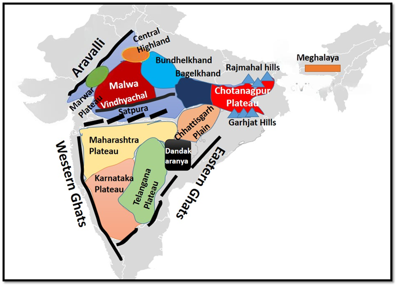
Major Physical Divisions of India : The Peninsular Plateau : Part 2 [Mapping] / भारत के प्रमुख भौतिक विभाग: प्रायद्वीपीय पठार: भाग 2 [मानचित्र]
- The Himalayan Mountains
- The Northern Plains
- The Peninsular Plateau
- The Indian Desert
- The Coastal Plains
- The Islands

The Peninsular Plateau – Part 2

Roughly triangular in shape with its base coinciding with the southern edge of the great plain of North India. Apex of the triangular plateau is at Kanniyakumari.
- It covers a total area of about 16 lakh sq km (India as a whole is 32 lakh sq km).
- The average height of the plateau is 600-900 m above sea level (varies from region to region).
- Most of the peninsular rivers flow west to east indicating it’s general slope.
- Narmada-Tapti are the exceptions which flow from east to west in a rift (rift is caused by divergent boundary (Go back to Interaction of plates).
- The Peninsular Plateau is a one of the oldest landforms of earth.
- It is a highly stable block composed mostly of the Archaean gneisses and schists {Rock System}.
- It has been a stable shield which has gone through little structural changes since its formation.
- Since few hundred million years, Peninsular block has been a land area and has never been submerged beneath the sea except in a few places.
- Peninsular Plateau is an aggregation of several smaller plateaus, hill ranges interspersed with river basins and valleys.
Minor Plateaus in the Peninsular Plateau
- Marwar Plateau or Mewar Plateau
- Central Highland
- Bundelkhand Upland
- Malwa Plateau
- Baghelkhand
- Chotanagpur Plateau
- Meghalaya Plateau
- Maharashtra Plateau
- Karnataka Plateau
- Telangana plateau
- Chhattisgarh Plain
Marwar Plateau or Mewar Plateau
- Baghelkhand
- North of the Maikal Range is the Baghelkhand.
- Made of limestones and sandstones on the west and granite in the east.
- It is bounded by the Son river on the north.
- The central part of the plateau acts as a water divide between the Son drainage system in the north and the Mahanadi river system in the south.
- The region is uneven with general elevation varying from 150 m to 1,200 m.
- The Bhanrer and Kaimur are located close to the trough-axis.
- The general horizontality of the strata shows that this area has not undergone any major disturbance.
- Chotanagpur Plateau
- Chotanagpur plateau represents the north-eastern projection of the Indian Peninsula.
- Mostly in Jharkhand, northern part of Chhatisgarh and Purulia district of West Bengal.
- The Son river flows in the north-west of the plateau and joins the Ganga.
- The average elevation of the plateau is 700 m above sea level.
- This plateau is composed mainly of Gondwana rocks.
- The plateau is drained by numerous rivers and streams in different directions and presents a radial drainage pattern. {Drainage Pattern}
- Rivers like the Damodar, the Subarnrekaha, the North Koel, the South Koel and the Barkar have developed extensive drainage basins.
- The Damodar river flows through the middle of this region in a rift valley from west to east. Here are found the Gondwana coal fields which provide bulk of coal in India.
- North of the Damodar river is the Hazaribagh plateau with an average elevation of 600 m above mean sea level. This plateau has isolated hills. It looks like a peneplain due to large scale erosion.
- The Ranchi Plateau to the south of the Damodar Valley rises to about 600 m above mean sea level. Most of the surface is rolling where the city of Ranchi (661 m) is located.
- At places it is interruped by monadnocks (an isolated hill or ridge of erosion-resistant rock rising above a peneplain. Ex: Ayers Rock in Australia) and conical hills.
- The Rajmahal Hills forming the north eastern edge of the Chotanagpur Plateau are mostly made of basalt and are covered by lava flows {Basaltic Lava}.
- They run in north-south direction and rise to average elevation of 400 m (highest mount is 567 m). These hills have been dissected into separate plateaus.
- Meghalaya Plateau
- The peninsular plateau extends further east beyond the Rajmahal hills to from Meghalaya or the Shillong plateau.
- Garo-Rajmahal Gap separates this plateau from the main block.
- This gap was formed by down-faulting (normal fault: a block of earth slides downwards). It was later filled by sediments deposited by the Ganga and Brahmaputa.
- The plateau is formed by Archaean quartzites, shales and schists.
- The plateau slopes down to Brahmaputra valley in the north and the Surma and Meghna valleys in the south.
- Its western boundary more or less coincides with the Bangladesh border.
- The western, central and the eastern parts of the plateau are known as the Garo Hills (900 m), the Khasi-Jaintia Hills (1,500 m) and the Mikir Hills (700 m).
- Shillong (1,961 m) is the highest point of the plateau.
- Deccan Plateau
- It covers an area of about five lakh sq km.
- It is triangular in shape and is bounded by the Satpura and the Vindhya in the north-west, the Mahadev and the Maikal in the north, the Western Ghats in the west and the Eastern Ghats in the east.
- Its average elevation is 600 m.
- It rises to 1000 m in the south but dips to 500 m in the north.
- Its general slope is from west to east which is indicated by the flow of its major rivers.
- Rivers have further subdivided this plateau into a number of smaller plateaus.
- Maharashtra Plateau
- The Maharashtra Plateau lies in Maharashtra.
- It forms the northern part of the Deccan Plateau.
- Much of the region is underlain by basaltic rocks of lava origin [Most of the Deccan Traps lies in this region].
- The area looks like a rolling plain due to weathering.
- The horizontal lava sheets have led to the formation of typical Deccan Trap topography [step like].
- The broad and shallow valleys of the Godavari, the Bhima and the Krishna are flanked [bordered on the opposite sides] by flat-topped steep sided hills and ridges.
- The entire area is covered by black cotton soil known as regur.
- Karnataka Plateau
- The Karnataka Plateau is also known as the Mysore plateau.
- Lies to the south of the Maharashtra plateau.
- The area looks like a rolling plateau with an average elevation of 600-900 m.
- It is highly dissected by numerous rivers rising from the Western Ghats.
- The general trend of the hills is either parallel to the Western Ghats or across it.
- The highest peak (1913 m) is at Mulangiri in Baba Budan Hills in Chikmaglur district.
- The plateau is divided into two parts called Malnad and Maidan.
- The Malnad in Kannada means hill country. It is dissected into deep valleys covered with dense forests.
- The Maidan on the other hand is formed of rolling plain with low granite hills.
- The plateau tapers between the Western Ghats and the Eastern Ghats in the south and merges with the Niligiri hills there.
- Telangana plateau
- The Telangana plateau consists of Archaean gneisses.
- It’s average elevation is 500-600 m.
- The southern part is higher than its northern counterpart.
- The region is drained by three river systems, the Godavari, the Krishna and the Penneru.
- The entire plateau is divided into Ghats and the Peneplains (a vast featureless, undulating plain which the last stage of deposition process).
- Chhattisgarh Plain
- The Chhattisgarh plain is the only plain worth the name in the Peninsular plateau.
- It is a saucer shaped depression drained by the upper Mahanadi.
- The whole basin lies between the Maikala Range and the Odisha hills.
- The region was once ruled by Haithaivanshi Rajputs from whose thirty six forts (Chhattisgarh) it derives its name.
- The basin is laid with nearly horizontal beds of limestone and shales.
- The general elevation of the plain ranges from 250 m in the east to 330 m in the west.
भारत के प्रमुख भौतिक विभाग: प्रायद्वीपीय पठार: भाग 2 [मानचित्र]
- हिमालय पर्वत
- उत्तरी मैदान
- प्रायद्वीपीय पठार
- भारतीय रेगिस्तान
- तटीय मैदान
- द्वीप
प्रायद्वीपीय पठार – भाग 2
मोटे तौर पर त्रिकोणीय आकार का यह पठार उत्तर भारत के विशाल मैदान के दक्षिणी किनारे से मेल खाता है। त्रिकोणीय पठार का शीर्ष कन्याकुमारी में है।
- इसका कुल क्षेत्रफल लगभग 16 लाख वर्ग किलोमीटर है (पूरा भारत 32 लाख वर्ग किलोमीटर है)।
- पठार की औसत ऊँचाई समुद्र तल से 600-900 मीटर है (क्षेत्र दर क्षेत्र अलग-अलग)।
- प्रायद्वीपीय नदियों में से अधिकांश पश्चिम से पूर्व की ओर बहती हैं, जो इसकी सामान्य ढलान को दर्शाती है।
- नर्मदा-ताप्ती अपवाद हैं जो पूर्व से पश्चिम की ओर एक दरार में बहती हैं (दरार विचलन सीमा के कारण होती है (प्लेटों की परस्पर क्रिया पर वापस जाएँ)।
- प्रायद्वीपीय पठार पृथ्वी के सबसे पुराने भू-आकृतियों में से एक है।
- यह एक अत्यधिक स्थिर ब्लॉक है जो ज्यादातर आर्कियन गनीस और शिस्ट {रॉक सिस्टम} से बना है।
- यह एक स्थिर ढाल रहा है जो इसके निर्माण के बाद से बहुत कम संरचनात्मक परिवर्तनों से गुजरा है।
- कुछ सौ मिलियन वर्षों से, प्रायद्वीपीय ब्लॉक एक भूमि क्षेत्र रहा है और कुछ स्थानों को छोड़कर कभी भी समुद्र के नीचे नहीं डूबा है।
- प्रायद्वीपीय पठार कई छोटे पठारों, पहाड़ी श्रृंखलाओं का एक समूह है जो नदी घाटियों और घाटियों के साथ मिला हुआ है।
प्रायद्वीपीय पठार में छोटे पठार
- मारवाड़ पठार या मेवाड़ पठार
- मध्य उच्चभूमि
- बुंदेलखंड अपलैंड
- मालवा पठार
- बघेलखंड
- छोटानागपुर पठार
- मेघालय पठार
- महाराष्ट्र पठार
- कर्नाटक पठार
- तेलंगाना पठार
- छत्तीसगढ़ मैदान
मारवाड़ पठार या मेवाड़ पठार
- बघेलखंड
- मैकाल पर्वतमाला के उत्तर में बघेलखंड है।
- पश्चिम में चूना पत्थर और बलुआ पत्थर तथा पूर्व में ग्रेनाइट से बना है।
- यह उत्तर में सोन नदी से घिरा है।
- पठार का मध्य भाग उत्तर में सोन अपवाह तंत्र तथा दक्षिण में महानदी नदी तंत्र के बीच जल विभाजक का कार्य करता है।
- यह क्षेत्र असमान है, तथा इसकी सामान्य ऊंचाई 150 मीटर से 1,200 मीटर तक है।
- भनेर तथा कैमूर गर्त-अक्ष के निकट स्थित हैं।
- परतों की सामान्य क्षैतिजता दर्शाती है कि इस क्षेत्र में कोई बड़ी उथल-पुथल नहीं हुई है।
- छोटानागपुर पठार
-
- छोटानागपुर पठार भारतीय प्रायद्वीप के उत्तर-पूर्वी प्रक्षेपण का प्रतिनिधित्व करता है।
- अधिकांशतः झारखंड, छत्तीसगढ़ के उत्तरी भाग तथा पश्चिम बंगाल के पुरुलिया जिले में स्थित है।
- सोन नदी पठार के उत्तर-पश्चिम में बहती है तथा गंगा में मिल जाती है।
- पठार की औसत ऊंचाई समुद्र तल से 700 मीटर है।
- यह पठार मुख्य रूप से गोंडवाना चट्टानों से बना है।
- पठार पर विभिन्न दिशाओं में कई नदियाँ और जलधाराएँ बहती हैं और यह एक रेडियल जल निकासी पैटर्न प्रस्तुत करता है। {जल निकासी पैटर्न}
- दामोदर, सुवर्णरेखा, उत्तरी कोयल, दक्षिणी कोयल और बरकर जैसी नदियों ने व्यापक जल निकासी घाटियाँ विकसित की हैं।
- दामोदर नदी पश्चिम से पूर्व की ओर एक दरार घाटी में इस क्षेत्र के मध्य से होकर बहती है। यहाँ गोंडवाना कोयला क्षेत्र पाए जाते हैं जो भारत में कोयले का बड़ा हिस्सा प्रदान करते हैं।
- दामोदर नदी के उत्तर में हजारीबाग पठार है जिसकी औसत ऊँचाई समुद्र तल से 600 मीटर है। इस पठार में अलग-अलग पहाड़ियाँ हैं। बड़े पैमाने पर कटाव के कारण यह एक प्रायद्वीप जैसा दिखता है।
- दामोदर घाटी के दक्षिण में रांची पठार समुद्र तल से लगभग 600 मीटर ऊपर उठता है। अधिकांश सतह ढलानदार है जहाँ रांची शहर (661 मीटर) स्थित है।
- कुछ स्थानों पर यह मोनाडनॉक्स (एक पृथक पहाड़ी या कटाव-रोधी चट्टान की रिज जो एक प्रायद्वीप के ऊपर उठती है। उदाहरण: ऑस्ट्रेलिया में आयर्स रॉक) और शंक्वाकार पहाड़ियों द्वारा बाधित है।
- छोटानागपुर पठार के उत्तर पूर्वी किनारे का निर्माण करने वाली राजमहल पहाड़ियाँ ज्यादातर बेसाल्ट से बनी हैं और लावा प्रवाह {बेसाल्टिक लावा} से ढकी हुई हैं।
- वे उत्तर-दक्षिण दिशा में चलती हैं और औसतन 400 मीटर (सबसे ऊँची पहाड़ी 567 मीटर है) की ऊँचाई तक उठती हैं। इन पहाड़ियों को अलग-अलग पठारों में विभाजित किया गया है।
- मेघालय का पठार
- प्रायद्वीपीय पठार राजमहल पहाड़ियों से आगे पूर्व में मेघालय या शिलांग पठार तक फैला हुआ है।
- गारो-राजमहल गैप इस पठार को मुख्य ब्लॉक से अलग करता है।
- यह गैप डाउन-फॉल्टिंग (सामान्य फॉल्ट: धरती का एक ब्लॉक नीचे की ओर खिसकता है) द्वारा बनाया गया था। इसे बाद में गंगा और ब्रह्मपुत्र द्वारा जमा किए गए तलछट से भर दिया गया था। o पठार का निर्माण आर्कियन क्वार्टजाइट्स, शेल्स और शिस्ट से हुआ है।
- पठार उत्तर में ब्रह्मपुत्र घाटी और दक्षिण में सूरमा और मेघना घाटियों तक नीचे की ओर झुकता है।
- इसकी पश्चिमी सीमा कमोबेश बांग्लादेश की सीमा से मिलती है।
- पठार के पश्चिमी, मध्य और पूर्वी भाग गारो हिल्स (900 मीटर), खासी-जयंतिया हिल्स (1,500 मीटर) और मिकिर हिल्स (700 मीटर) के नाम से जाने जाते हैं।
- शिलांग (1,961 मीटर) पठार का सबसे ऊँचा स्थान है।
- डेक्कन पठार
- यह लगभग पाँच लाख वर्ग किलोमीटर क्षेत्र में फैला हुआ है।
- यह आकार में त्रिभुजाकार है और उत्तर-पश्चिम में सतपुड़ा और विंध्य, उत्तर में महादेव और मैकाल, पश्चिम में पश्चिमी घाट और पूर्व में पूर्वी घाट से घिरा हुआ है।
- इसकी औसत ऊँचाई 600 मीटर है।
- यह दक्षिण में 1000 मीटर तक ऊँचा है, लेकिन उत्तर में 500 मीटर तक गिर जाता है।
- इसका सामान्य ढलान पश्चिम से पूर्व की ओर है, जो इसकी प्रमुख नदियों के प्रवाह से संकेतित होता है।
- नदियों ने इस पठार को कई छोटे पठारों में विभाजित कर दिया है।
- महाराष्ट्र पठार
- महाराष्ट्र पठार महाराष्ट्र में स्थित है।
- यह दक्कन पठार का उत्तरी भाग बनाता है।
- इस क्षेत्र का अधिकांश भाग लावा मूल की बेसाल्टिक चट्टानों से ढका हुआ है [अधिकांश दक्कन ट्रैप इसी क्षेत्र में स्थित हैं]।
- यह क्षेत्र अपक्षय के कारण एक लुढ़कते मैदान जैसा दिखता है।
- क्षैतिज लावा चादरों ने विशिष्ट दक्कन ट्रैप स्थलाकृति [सीढ़ीनुमा] का निर्माण किया है।
- गोदावरी, भीमा और कृष्णा की चौड़ी और उथली घाटियाँ समतल-शीर्ष वाली खड़ी पहाड़ियों और कटकों से घिरी हुई हैं।
- पूरा क्षेत्र काली कपास मिट्टी से ढका हुआ है जिसे रेगुर के नाम से जाना जाता है।
- कर्नाटक पठार
- कर्नाटक पठार को मैसूर पठार के नाम से भी जाना जाता है।
- महाराष्ट्र पठार के दक्षिण में स्थित है।
- यह क्षेत्र 600-900 मीटर की औसत ऊंचाई के साथ एक लुढ़कते पठार जैसा दिखता है।
- यह पश्चिमी घाट से निकलने वाली कई नदियों द्वारा अत्यधिक विच्छेदित है।
- पहाड़ियों की सामान्य प्रवृत्ति या तो पश्चिमी घाट के समानांतर है या इसके पार है।
- सबसे ऊँची चोटी (1913 मीटर) चिकमगलूर जिले में बाबा बुदन पहाड़ियों में मुलंगिरी में है।
- पठार को दो भागों में विभाजित किया गया है जिन्हें मलनाड और मैदान कहा जाता है।
- कन्नड़ में मलनाड का अर्थ पहाड़ी देश है। यह घने जंगलों से ढकी गहरी घाटियों में विभाजित है।
- दूसरी ओर मैदान कम ग्रेनाइट पहाड़ियों के साथ लुढ़कते मैदान से बना है।
- पठार दक्षिण में पश्चिमी घाट और पूर्वी घाट के बीच पतला होता जाता है और वहाँ नीलगिरी पहाड़ियों में विलीन हो जाता है।
- तेलंगाना पठार
- तेलंगाना पठार में आर्कियन गनीस शामिल हैं।
- इसकी औसत ऊँचाई 500-600 मीटर है।
- दक्षिणी भाग अपने उत्तरी समकक्ष से अधिक ऊँचा है।
- इस क्षेत्र में तीन नदी प्रणालियाँ, गोदावरी, कृष्णा और पेननेरू बहती हैं।
- पूरा पठार घाट और पेनेप्लेन (एक विशाल, बिना किसी विशेषता वाला, लहरदार मैदान जो निक्षेपण प्रक्रिया का अंतिम चरण है) में विभाजित है।
छत्तीसगढ़ का मैदान
- प्रायद्वीपीय पठार में छत्तीसगढ़ का मैदान नाम के योग्य एकमात्र मैदान है।
- यह ऊपरी महानदी द्वारा बहाया जाने वाला एक तश्तरी के आकार का अवसाद है।
- पूरा बेसिन मैकाल रेंज और ओडिशा पहाड़ियों के बीच स्थित है।
- इस क्षेत्र पर कभी हैथैववंशी राजपूतों का शासन था, जिनके छत्तीस किलों (छत्तीसगढ़) से इसका नाम पड़ा है।
- बेसिन चूना पत्थर और शेल के लगभग क्षैतिज बिस्तरों से बना है।
- मैदान की सामान्य ऊंचाई पूर्व में 250 मीटर से लेकर पश्चिम में 330 मीटर तक है।