CURRENT AFFAIRS – 24/06/2024
- CURRENT AFFAIRS – 24/06/2024
- Sherds with geometric symbols unearthed during excavations at Perumbalai in T.N. / तमिलनाडु के पेरुम्बलाई में खुदाई के दौरान ज्यामितीय प्रतीकों वाले अवशेष मिले।
- Fear of IEDs returns to Telangana’s border villages / तेलंगाना के सीमावर्ती गांवों में आईईडी का डर फिर से लौट आया
- After years, Russia approves draft logistics agreement to be signed with India / सालों बाद रूस ने भारत के साथ हस्ताक्षरित होने वाले लॉजिस्टिक्स समझौते के मसौदे को मंजूरी दी
- Pushpak, ISRO’s reusable launch vehicle, clears test / इसरो के पुन: प्रयोज्य प्रक्षेपण यान पुष्पक ने परीक्षण पास कर लिया
- What are the duties of a Speaker? / स्पीकर के कर्तव्य क्या हैं?
- Indian Railways and safety challenges / भारतीय रेलवे और सुरक्षा चुनौतियाँ
- Major Physical Divisions of India : The Himalaya Mountain Ranges [Mapping] / भारत के प्रमुख भौतिक प्रभाग: हिमालय पर्वत श्रृंखलाएँ
CURRENT AFFAIRS – 24/06/2024
Sherds with geometric symbols unearthed during excavations at Perumbalai in T.N. / तमिलनाडु के पेरुम्बलाई में खुदाई के दौरान ज्यामितीय प्रतीकों वाले अवशेष मिले।
(General Studies- Paper I)
Source : The Hindu
Tamil Nadu’s Department of Archaeology has uncovered ancient graffiti-marked potsherds at Perumbalai, Dharmapuri district, dating back to the 6th Century BCE.The findings, including over 1,000 inscribed potsherds and various antiquities, provide significant insights into the Iron Age and early historic periods in the region.
Significance of these excavations:
- Historical Insight: The findings at Perumbalai provide valuable information about the Iron Age and early historic period in Tamil Nadu, dating back to the 6th Century BCE.
- Cultural Continuity: The presence of Tamil (Tamil-Brahmi) inscriptions and graffiti marks similar to those found at other historic sites like Keeladi and Uraiyur indicates cultural and linguistic continuity in the region.
- Pottery Analysis: The diverse pottery assemblage, including fine BRW and black ware, helps establish a chronological framework and reveals advanced pottery techniques of the period.
- Elite Ware: Russet-coated ware identified as elite table ware suggests social stratification and the existence of a class that used finer pottery.
- Antiquities: The variety of terracotta objects and metal artefacts, including human and bird figurines, beads, and a copper coin, provides insights into daily life, trade, and artistic practices.
तमिलनाडु के पेरुम्बलाई में खुदाई के दौरान ज्यामितीय प्रतीकों वाले अवशेष मिले।
तमिलनाडु के पुरातत्व विभाग ने धर्मपुरी जिले के पेरुंबलई में 6वीं शताब्दी ईसा पूर्व के प्राचीन भित्तिचित्र-चिह्नित बर्तनों के टुकड़े खोजे हैं। 1,000 से अधिक उत्कीर्ण बर्तनों के टुकड़े और विभिन्न पुरावशेषों सहित ये खोजें इस क्षेत्र में लौह युग और प्रारंभिक ऐतिहासिक अवधियों के बारे में महत्वपूर्ण जानकारी प्रदान करती हैं।
इन उत्खननों का महत्व:
- ऐतिहासिक अंतर्दृष्टि: पेरुम्बलाई में प्राप्त खोज तमिलनाडु में लौह युग और प्रारंभिक ऐतिहासिक काल के बारे में बहुमूल्य जानकारी प्रदान करती है, जो 6वीं शताब्दी ईसा पूर्व से शुरू होती है।
- सांस्कृतिक निरंतरता: तमिल (तमिल-ब्राह्मी) शिलालेखों और भित्तिचित्रों की उपस्थिति, जो किलाडी और उरईयूर जैसे अन्य ऐतिहासिक स्थलों पर पाए गए हैं, इस क्षेत्र में सांस्कृतिक और भाषाई निरंतरता को इंगित करती है।
- मिट्टी के बर्तनों का विश्लेषण: बढ़िया बीआरडब्ल्यू और काले बर्तनों सहित विविध मिट्टी के बर्तनों का संग्रह, एक कालानुक्रमिक रूपरेखा स्थापित करने में मदद करता है और उस अवधि की उन्नत मिट्टी के बर्तनों की तकनीकों को प्रकट करता है।
- एलिट वेयर: कुलीन टेबल वेयर के रूप में पहचाने जाने वाले रसेट-कोटेड बर्तन सामाजिक स्तरीकरण और एक ऐसे वर्ग के अस्तित्व का सुझाव देते हैं जो महीन मिट्टी के बर्तनों का उपयोग करते थे।
- पुरातनता: मानव और पक्षी मूर्तियों, मोतियों और एक तांबे के सिक्के सहित टेराकोटा वस्तुओं और धातु की कलाकृतियों की विविधता, दैनिक जीवन, व्यापार और कलात्मक प्रथाओं में अंतर्दृष्टि प्रदान करती है।
Fear of IEDs returns to Telangana’s border villages / तेलंगाना के सीमावर्ती गांवों में आईईडी का डर फिर से लौट आया
(General Studies- Paper III)
Source : The Hindu
The resurgence of Improvised Explosive Devices (IEDs) by Maoists on the Telangana-Chhattisgarh border is posing new challenges for police.Recent IED incidents have resulted in civilian casualties, highlighting the ongoing conflict and the unintended victims of the Maoists’ tactics against security forces.
- The resurgence of Improvised Explosive Devices (IEDs) by left-wing extremists, particularly the Maoists, poses a new challenge for police on the Telangana-Chhattisgarh boundary.
- In the past three months, five IED explosions have occurred, killing two civilians and injuring three others in the bordering districts of the two states.
- Civilians, particularly those in forest and village areas, have inadvertently become victims of these IEDs.
- Persistent combing operations by commando forces and local police had previously reduced Maoist movements in recent years.
- Maoists have faced significant losses recently, with many members and leaders killed in exchanges of fire in Chhattisgarh.
- The use of IEDs dates back to the late 1980s when Maoists, initially known as the People’s War Group of Naxalites, first adopted this tactic.
- The first evidence of IED usage by Maoists was discovered in the mid-1980s in Nachinapalli village, Warangal district.
- Although the use of IEDs declined with the reduction in Maoist activities, recent months have seen a resurgence.
- IEDs are used to confuse and delay security forces, stalling their movements and allowing Maoists to regroup or change strategies.
तेलंगाना के सीमावर्ती गांवों में आईईडी का डर फिर से लौट आया
तेलंगाना-छत्तीसगढ़ सीमा पर माओवादियों द्वारा इम्प्रोवाइज्ड एक्सप्लोसिव डिवाइस (आईईडी) का फिर से आना पुलिस के लिए नई चुनौतियां पेश कर रहा है। हाल की आईईडी घटनाओं में नागरिक हताहत हुए हैं, जिससे चल रहे संघर्ष और सुरक्षा बलों के खिलाफ माओवादियों की रणनीति के कारण होने वाले अनपेक्षित पीड़ितों पर प्रकाश डाला गया है।
- वामपंथी उग्रवादियों, खास तौर पर माओवादियों द्वारा इम्प्रोवाइज्ड एक्सप्लोसिव डिवाइस (आईईडी) का फिर से इस्तेमाल तेलंगाना-छत्तीसगढ़ सीमा पर पुलिस के लिए नई चुनौती बन गया है।
- पिछले तीन महीनों में, दोनों राज्यों के सीमावर्ती जिलों में पांच आईईडी विस्फोट हुए हैं, जिनमें दो नागरिकों की मौत हो गई और तीन अन्य घायल हो गए।
- नागरिक, खास तौर पर जंगल और गांव के इलाकों में रहने वाले लोग, अनजाने में इन आईईडी के शिकार बन गए हैं।
- कमांडो बलों और स्थानीय पुलिस द्वारा लगातार तलाशी अभियान चलाने से हाल के वर्षों में माओवादी गतिविधियों में कमी आई है।
- हाल ही में माओवादियों को काफी नुकसान उठाना पड़ा है, छत्तीसगढ़ में गोलीबारी में उनके कई सदस्य और नेता मारे गए हैं।
- आईईडी का इस्तेमाल 1980 के दशक के आखिर में शुरू हुआ था, जब माओवादियों ने, जिन्हें शुरू में नक्सलियों के पीपुल्स वार ग्रुप के नाम से जाना जाता था, पहली बार इस रणनीति को अपनाया था।
- माओवादियों द्वारा IED के इस्तेमाल का पहला सबूत 1980 के दशक के मध्य में वारंगल जिले के नचिनापल्ली गांव में मिला था।
- हालाँकि माओवादी गतिविधियों में कमी के साथ IED के इस्तेमाल में कमी आई है, लेकिन हाल के महीनों में इसमें फिर से उछाल देखा गया है।
- IED का इस्तेमाल सुरक्षा बलों को भ्रमित करने और उन्हें विलंबित करने, उनकी गतिविधियों को रोकने और माओवादियों को फिर से संगठित होने या रणनीति बदलने का मौका देने के लिए किया जाता है।
After years, Russia approves draft logistics agreement to be signed with India / सालों बाद रूस ने भारत के साथ हस्ताक्षरित होने वाले लॉजिस्टिक्स समझौते के मसौदे को मंजूरी दी
(General Studies- Paper II)
Source : The Hindu
India and Russia have finalised a long-awaited mutual logistics agreement, akin to those India has with other nations like the U.S.The agreement aims to streamline military exchanges, training, and humanitarian efforts, bolstering their strategic defence partnership.
- India and Russia have finalised a mutual logistics agreement after years of delay, akin to those India has with other countries.
- The agreement facilitates military exchanges, exercises, training, port calls, and disaster relief efforts.
- Russia’s approval via a governmental decree paves the way for negotiations and signing by both nations.
- This agreement, part of strategic defence cooperation, will initially be valid for five years and automatically renew unless terminated.
- It complements existing military technical cooperation and aims to enhance interoperability and operational efficiency, especially for the Indian Navy.
सालों बाद रूस ने भारत के साथ हस्ताक्षरित होने वाले लॉजिस्टिक्स समझौते के मसौदे को मंजूरी दी
भारत और रूस ने लंबे समय से प्रतीक्षित पारस्परिक रसद समझौते को अंतिम रूप दे दिया है, जैसा कि भारत ने अमेरिका जैसे अन्य देशों के साथ किया है। इस समझौते का उद्देश्य सैन्य आदान-प्रदान, प्रशिक्षण और मानवीय प्रयासों को सुव्यवस्थित करना तथा उनकी रणनीतिक रक्षा साझेदारी को मजबूत करना है।
- भारत और रूस ने कई वर्षों की देरी के बाद आपसी रसद समझौते को अंतिम रूप दिया है, जैसा कि भारत ने अन्य देशों के साथ किया है।
- यह समझौता सैन्य आदान-प्रदान, अभ्यास, प्रशिक्षण, बंदरगाह कॉल और आपदा राहत प्रयासों की सुविधा प्रदान करता है।
- रूस द्वारा सरकारी आदेश के माध्यम से स्वीकृति दिए जाने से दोनों देशों के बीच बातचीत और हस्ताक्षर का मार्ग प्रशस्त होता है।
- यह समझौता, रणनीतिक रक्षा सहयोग का हिस्सा है, जो शुरू में पाँच वर्षों के लिए वैध होगा और समाप्त होने तक स्वतः नवीनीकृत हो जाएगा।
- यह मौजूदा सैन्य तकनीकी सहयोग का पूरक है और इसका उद्देश्य विशेष रूप से भारतीय नौसेना के लिए अंतर-संचालन और परिचालन दक्षता को बढ़ाना है।
Pushpak, ISRO’s reusable launch vehicle, clears test / इसरो के पुन: प्रयोज्य प्रक्षेपण यान पुष्पक ने परीक्षण पास कर लिया
Syllabus : Prelims Fact
ISRO completed the third Reusable Launch Vehicle (RLV) Landing Experiment (LEX) of its winged vehicle ‘Pushpak’, at the Aeronautical Test Range (ATR) in Chitradurga, Karnataka.
- ISRO successfully completed its third reusable launch vehicle landing experiment (RLV LEX-03) at the Aeronautical Test Range in Chitradurga, Karnataka.
- The experiment re-demonstrated autonomous landing under more challenging conditions.
- The winged vehicle, Pushpak, was released from an Indian Air Force Chinook helicopter at an altitude of 4.5 km.
- Pushpak executed cross-range correction manoeuvres and performed a precise horizontal landing at the runway centerline.
- The mission simulated high-speed landing conditions for a vehicle returning from space.
- Advanced guidance algorithms for error corrections essential for future orbital re-entry missions were validated.
- The LEX-03 mission reused winged body and flight systems from the LEX-02 mission without modification.
Significance of RLVs
- Low lift-to-drag (L/D) ratio: In aerodynamics, the L/D ratio is the lift generated by an aircraft, divided by the aerodynamic drag caused by moving through air.
- Cost-effective: The use of two staged RLVs can reduce the cost of a launch by nearly 80% of the current cost.
- Foundation for advanced technologies: It has the potential to serve as the foundation for advanced technologies such as
- Hypersonic flight,
- Autonomous landing,
- Return flight experimentation,
- Powered cruise flight, and
- Air-breathing propulsion systems.
- Scientific, strategic and commercial advantages for India: The building of RLVs will ensure that the country does not lag in important scientific and strategic areas and will also commercially help ISRO.
इसरो के पुन: प्रयोज्य प्रक्षेपण यान पुष्पक ने परीक्षण पास कर लिया
इसरो ने कर्नाटक के चित्रदुर्ग स्थित वैमानिकी परीक्षण रेंज (एटीआर) में अपने पंखयुक्त वाहन ‘पुष्पक’ के तीसरे पुन: प्रयोज्य प्रक्षेपण यान (आरएलवी) लैंडिंग प्रयोग (लेक्स) को पूरा कर लिया।
- इसरो ने कर्नाटक के चित्रदुर्ग में एयरोनॉटिकल टेस्ट रेंज में अपना तीसरा पुन: प्रयोज्य लॉन्च वाहन लैंडिंग प्रयोग (RLV LEX-03) सफलतापूर्वक पूरा किया।
- इस प्रयोग ने अधिक चुनौतीपूर्ण परिस्थितियों में स्वायत्त लैंडिंग का पुनः प्रदर्शन किया।
- पंखों वाले वाहन, पुष्पक को भारतीय वायु सेना के चिनूक हेलीकॉप्टर से 5 किमी की ऊँचाई पर छोड़ा गया।
- पुष्पक ने क्रॉस-रेंज सुधार युद्धाभ्यास किया और रनवे सेंटरलाइन पर सटीक क्षैतिज लैंडिंग की।
- इस मिशन ने अंतरिक्ष से लौटने वाले वाहन के लिए उच्च गति वाली लैंडिंग स्थितियों का अनुकरण किया।
- भविष्य के कक्षीय पुनः प्रवेश मिशनों के लिए आवश्यक त्रुटि सुधारों के लिए उन्नत मार्गदर्शन एल्गोरिदम को मान्य किया गया।
- LEX-03 मिशन ने बिना किसी संशोधन के LEX-02 मिशन से पंख वाले शरीर और उड़ान प्रणालियों का पुनः उपयोग किया।
RLV का महत्व
- कम लिफ्ट-टू-ड्रैग (L/D) अनुपात: वायुगतिकी में, L/D अनुपात एक विमान द्वारा उत्पन्न लिफ्ट है, जिसे हवा के माध्यम से चलने के कारण होने वाले वायुगतिकीय ड्रैग से विभाजित किया जाता है।
- लागत प्रभावी: दो चरण वाले आरएलवी के उपयोग से प्रक्षेपण की लागत वर्तमान लागत का लगभग 80% कम हो सकती है। उन्नत प्रौद्योगिकियों के लिए आधार: इसमें उन्नत प्रौद्योगिकियों के लिए आधार के रूप में काम करने की क्षमता है जैसे
- हाइपरसोनिक उड़ान,
- स्वायत्त लैंडिंग,
- वापसी उड़ान प्रयोग,
- संचालित क्रूज उड़ान, और
- वायु-श्वास प्रणोदन प्रणाली।
- भारत के लिए वैज्ञानिक, रणनीतिक और वाणिज्यिक लाभ: आरएलवी के निर्माण से यह सुनिश्चित होगा कि देश महत्वपूर्ण वैज्ञानिक और रणनीतिक क्षेत्रों में पीछे नहीं रहेगा और इससे इसरो को वाणिज्यिक रूप से भी मदद मिलेगी।
What are the duties of a Speaker? / स्पीकर के कर्तव्य क्या हैं?
(General Studies- Paper II)
Source : The Hindu
Bhartruhari Mahtab has been appointed as Speaker pro tem for the 18th Lok Sabha, overseeing initial proceedings until a full-time Speaker is elected on June 26.
- Speaker Pro tem Appointment: Bhartruhari Mahtab appointed as Speaker pro tem for the 18th Lok Sabha, facilitating oath administration to MPs and overseeing the election of the full-time Speaker.
- Constitutional Basis: Article 94 ensures the Speaker remains in office until the new Lok Sabha convenes, with Article 95(1) enabling the President to appoint a temporary Speaker in case of vacancy.
- Role and Function: Speaker pro tem’s role is temporary and ceremonial, administering oaths and presiding over initial proceedings until a full-time Speaker is elected.
- Election of Speaker: Governed by Article 93, the Speaker is elected unopposed traditionally, with the President fixing the election date.
- Deputy Speaker: Article 93 also mandates the election of a Deputy Speaker, historically offered to the Opposition since 1991, except in the 17th Lok Sabha.
- Speaker’s Constitutional Roles: Certifies Money Bills and adjudicates on defection under the Tenth Schedule, with past instances of perceived bias towards ruling dispensations.
- Lok Sabha Rules: Grants Speaker powers to refer Bills to Standing Committees and suspend members for disorder, though referrals have declined.
- British Speaker’s Impartiality: Contrasts with UK practice where Speakers resign from party affiliation, reflecting neutrality in House proceedings.
- Historical Precedents: Somnath Chatterjee’s tenure exemplified independence by not resigning despite party directives, setting a precedent.
स्पीकर के कर्तव्य क्या हैं?
भारत के लिए वैज्ञानिक, रणनीतिक और वाणिज्यिक लाभ: आरएलवी के निर्माण से यह सुनिश्चित होगा कि देश महत्वपूर्ण वैज्ञानिक और रणनीतिक क्षेत्रों में पीछे नहीं रहेगा और इससे इसरो को वाणिज्यिक रूप से भी मदद मिलेगी।
- प्रोटेम स्पीकर की नियुक्ति: भर्तृहरि महताब को 18वीं लोकसभा के लिए प्रोटेम स्पीकर नियुक्त किया गया है, जो सांसदों को शपथ दिलाने और पूर्णकालिक अध्यक्ष के चुनाव की देखरेख करेंगे।
- संवैधानिक आधार: अनुच्छेद 94 यह सुनिश्चित करता है कि अध्यक्ष तब तक पद पर बने रहें जब तक कि नई लोकसभा का गठन न हो जाए, अनुच्छेद 95(1) राष्ट्रपति को रिक्ति की स्थिति में अस्थायी अध्यक्ष नियुक्त करने में सक्षम बनाता है।
- भूमिका और कार्य: प्रोटेम स्पीकर की भूमिका अस्थायी और औपचारिक होती है, जो पूर्णकालिक अध्यक्ष के निर्वाचित होने तक शपथ दिलाते हैं और प्रारंभिक कार्यवाही की अध्यक्षता करते हैं।
- अध्यक्ष का चुनाव: अनुच्छेद 93 के अनुसार, अध्यक्ष का चुनाव पारंपरिक रूप से निर्विरोध होता है, जिसमें राष्ट्रपति चुनाव की तिथि तय करते हैं।
- उपाध्यक्ष: अनुच्छेद 93 में उपाध्यक्ष के चुनाव का भी प्रावधान है, जो ऐतिहासिक रूप से 17वीं लोकसभा को छोड़कर 1991 से विपक्ष को दिया जाता रहा है।
- अध्यक्ष की संवैधानिक भूमिकाएँ: दसवीं अनुसूची के तहत धन विधेयकों को प्रमाणित करना और दलबदल पर निर्णय लेना, सत्तारूढ़ व्यवस्था के प्रति कथित पक्षपात के पिछले उदाहरणों के साथ।
- लोकसभा नियम: अध्यक्ष को विधेयकों को स्थायी समितियों को संदर्भित करने और अव्यवस्था के लिए सदस्यों को निलंबित करने की शक्तियाँ प्रदान करता है, हालाँकि रेफरल में कमी आई है।
- ब्रिटिश अध्यक्ष की निष्पक्षता: ब्रिटेन की प्रथा के विपरीत, जहाँ अध्यक्ष पार्टी संबद्धता से इस्तीफा दे देते हैं, जो सदन की कार्यवाही में तटस्थता को दर्शाता है।
- ऐतिहासिक मिसालें: सोमनाथ चटर्जी के कार्यकाल ने पार्टी के निर्देशों के बावजूद इस्तीफा न देकर स्वतंत्रता का उदाहरण पेश किया, जो एक मिसाल कायम करता है।
Indian Railways and safety challenges / भारतीय रेलवे और सुरक्षा चुनौतियाँ
(General Studies- Paper III)
Source : The Hindu
Context : A recent tragic collision between a GFCJ container train and the 13174 Agartala-Sealdah Kanchanjunga Express resulted in 11 deaths and about 40 injuries, highlighting critical safety issues within Indian Railways.This incident underscores the need for improved safety protocols, better management, and faster implementation of safety technologies.
Introduction
- The dust and din have not settled since the tragic accident involving the GFCJ container train (goods train), which, while travelling at high speed, rammed into the 13174 Agartala-Sealdah Kanchanjunga Express, resulting in 11 deaths and approximately 40 injuries.
The underlying issues
- Thanks to focused measures like closing unmanned level crossings and emphasising track maintenance, the safety record of Indian Railways in terms of fatalities and injuries has certainly improved.
- However, comparing this data to past records to paint a rosy picture is misleading.
- Modern systems and tools make achieving a zero-fatality record an attainable goal, and this is what the Railways should be pursuing.
- Moreover, the Union government’s substantial investment, allocating nearly 25% of its total capex to railways, makes funding all safety works well within the Indian Railway’s reach.
- The non-availability of resources cannot be a red herring any more.
- A statutory inquiry by the Commissioner of Railway Safety (CRS) is under way, and the cause and responsibility for the accident will soon be determined.
- It is almost a foregone conclusion that the crew of the GFCJ container train, the station master, and perhaps even the signal maintainer will be held responsible for ignoring the stipulated Automatic Signal territory protocol.
- This pattern of assigning blame to lower level functionaries repeats with each serious accident.
- There are other issues which may or may not be routine and beg more attention.
- First, the information management and communication of Indian Railways. Even as facts about the accident were still emerging, the Chairperson of the Railway Board prematurely declared the container train crew’s disregard of signals as the prima facie cause.
- She also stated that both crew members had died. While the former is proving to be only partially true, the latter was an insensitive and erroneous statement as the assistant loco pilot has survived.
- Notably, the Railways decided to adopt the Kavach system after extensive trials over 1,400 kilometres on the Southern Central Railway nearly three years ago, preferring it over the established European system, ETCS Level II.
- The project has been a work in progress since then. Such slow execution of a project indicates a lack of focus on safety works.
- If that is indeed the case, there is no harm in installing ETCS Level II in some important sections while Kavach matures.
- Kavach is under implementation on the Delhi-Howrah and Delhi-Mumbai sections, but the target for completion has been missed.
- The CRS’ report on the Vizianagaram train accident emphasised the priority implementation of Kavach in Automatic Signalling territories, as they are prone to collisions, and suggested faster installation in locomotives and trains ahead of ground installations to increase the probability, if not guarantee, of preventing collisions.
- The Railways should fixate on the trunk routes and Automatic Signalling territories for faster installation of Kavach, aiming for 4,000 to 5,000 km/year, which is achievable.
- Indian Railways, like many government entities, is overstaffed. However, there are some safety-critical categories where work is intensely continuous, such as loco crew, train manager, station master, pointsman and signal maintainer.
- Any vacancies in these categories mean stress and overwork for the existing staff.
- Carrying such vacancies to save some expenditure is self-defeating. Although there are nearly 20,000 vacancies for loco pilot/assistant loco pilot positions.
- A related issue is the inaction in employing AI-enabled applications to improve safety post mortems and provide actionable alerts.
- Extensive digital data from station data loggers and microprocessors on locomotives and trains can be effectively managed by AI, filtering out the irregularities to precipitate the grave ones and projecting them regularly to the very top of railway management.
Conclusion
- A big question is whether the accident was an aberration or if similar near misses are commonplace in the affected section. If the enquiry shows that such incidents were indeed frequent, it would point to a grave management failure.
भारतीय रेलवे और सुरक्षा चुनौतियाँ
प्रसंग : हाल ही में जीएफसीजे कंटेनर ट्रेन और 13174 अगरतला-सियालदह कंचनजंगा एक्सप्रेस के बीच हुई दुखद टक्कर में 11 लोगों की मौत हो गई और लगभग 40 लोग घायल हो गए, जिससे भारतीय रेलवे में सुरक्षा संबंधी गंभीर मुद्दे उजागर हुए हैं। यह घटना बेहतर सुरक्षा प्रोटोकॉल, बेहतर प्रबंधन और सुरक्षा प्रौद्योगिकियों के तेजी से कार्यान्वयन की आवश्यकता को रेखांकित करती है।
परिचय
- जीएफसीजे कंटेनर ट्रेन (मालगाड़ी) से जुड़ी दुखद दुर्घटना के बाद से धूल और शोर कम नहीं हुआ है, जो तेज गति से यात्रा करते हुए 13174 अगरतला-सियालदह कंचनजंगा एक्सप्रेस से टकरा गई, जिसके परिणामस्वरूप 11 लोगों की मौत हो गई और लगभग 40 लोग घायल हो गए।
मूलभूत मुद्दे
- मानव रहित लेवल क्रॉसिंग को बंद करने और ट्रैक रखरखाव पर जोर देने जैसे केंद्रित उपायों की बदौलत, मौतों और चोटों के मामले में भारतीय रेलवे का सुरक्षा रिकॉर्ड निश्चित रूप से बेहतर हुआ है।
- हालांकि, इस डेटा की तुलना पिछले रिकॉर्ड से करके एक गुलाबी तस्वीर पेश करना भ्रामक है।
- आधुनिक सिस्टम और उपकरण शून्य-मृत्यु रिकॉर्ड को प्राप्त करना एक प्राप्त करने योग्य लक्ष्य बनाते हैं, और यही वह है जिसे रेलवे को अपनाना चाहिए।
- इसके अलावा, केंद्र सरकार का पर्याप्त निवेश, अपने कुल पूंजीगत व्यय का लगभग 25% रेलवे को आवंटित करना, सभी सुरक्षा कार्यों को भारतीय रेलवे की पहुंच के भीतर वित्तपोषित करता है।
- संसाधनों की अनुपलब्धता अब और भ्रामक नहीं हो सकती।
- रेलवे सुरक्षा आयुक्त (सीआरएस) द्वारा वैधानिक जांच चल रही है, तथा दुर्घटना के कारण और जिम्मेदारी का जल्द ही पता लगाया जाएगा।
- यह लगभग तय है कि जीएफसीजे कंटेनर ट्रेन के चालक दल, स्टेशन मास्टर और शायद सिग्नल मेंटेनर को भी निर्धारित स्वचालित सिग्नल क्षेत्र प्रोटोकॉल की अनदेखी के लिए जिम्मेदार ठहराया जाएगा।
- निचले स्तर के अधिकारियों को दोषी ठहराने का यह पैटर्न प्रत्येक गंभीर दुर्घटना के साथ दोहराया जाता है। ऐसे अन्य मुद्दे भी हैं जो नियमित हो सकते हैं या नहीं भी हो सकते हैं और जिन पर अधिक ध्यान देने की आवश्यकता है।
- सबसे पहले, भारतीय रेलवे का सूचना प्रबंधन और संचार। दुर्घटना के बारे में तथ्य अभी भी सामने आ रहे थे, रेलवे बोर्ड की अध्यक्ष ने समय से पहले ही कंटेनर ट्रेन चालक दल द्वारा सिग्नल की अनदेखी को प्रथम दृष्टया कारण घोषित कर दिया।
- उन्होंने यह भी कहा कि चालक दल के दोनों सदस्यों की मृत्यु हो गई थी। जबकि पहला कथन आंशिक रूप से ही सत्य साबित हो रहा है, दूसरा कथन एक असंवेदनशील और गलत कथन था क्योंकि सहायक लोको पायलट बच गया है।
- उल्लेखनीय है कि रेलवे ने लगभग तीन साल पहले दक्षिणी मध्य रेलवे पर 1,400 किलोमीटर से अधिक के व्यापक परीक्षणों के बाद कवच प्रणाली को अपनाने का फैसला किया था, और इसे स्थापित यूरोपीय प्रणाली, ईटीसीएस लेवल II पर प्राथमिकता दी थी। तब से यह परियोजना प्रगति पर है।
- किसी परियोजना का इतना धीमा क्रियान्वयन सुरक्षा कार्यों पर ध्यान केंद्रित न करने का संकेत देता है।
- यदि वास्तव में ऐसा है, तो कवच के परिपक्व होने तक कुछ महत्वपूर्ण खंडों में ईटीसीएस लेवल II स्थापित करने में कोई बुराई नहीं है।
- दिल्ली-हावड़ा और दिल्ली-मुंबई खंडों पर कवच का कार्यान्वयन किया जा रहा है, लेकिन पूरा होने का लक्ष्य चूक गया है।
- विजयनगरम ट्रेन दुर्घटना पर सीआरएस की रिपोर्ट ने स्वचालित सिग्नलिंग क्षेत्रों में कवच के प्राथमिकता कार्यान्वयन पर जोर दिया, क्योंकि वे टकरावों के लिए प्रवण हैं, और टकरावों को रोकने की गारंटी नहीं तो संभावना बढ़ाने के लिए लोकोमोटिव और ट्रेनों में जमीन पर स्थापना से पहले तेजी से स्थापना का सुझाव दिया।
- रेलवे को कवच की तेज़ स्थापना के लिए ट्रंक रूट और स्वचालित सिग्नलिंग क्षेत्रों पर ध्यान केंद्रित करना चाहिए, जिसका लक्ष्य 4,000 से 5,000 किलोमीटर/वर्ष है, जो प्राप्त करने योग्य है।
- भारतीय रेलवे, कई सरकारी संस्थाओं की तरह, कर्मचारियों की संख्या से अधिक है। हालाँकि, कुछ सुरक्षा-महत्वपूर्ण श्रेणियाँ हैं जहाँ काम बहुत अधिक निरंतर होता है, जैसे लोको क्रू, ट्रेन मैनेजर, स्टेशन मास्टर, पॉइंट्समैन और सिग्नल मेंटेनर।
- इन श्रेणियों में किसी भी रिक्ति का मतलब मौजूदा कर्मचारियों के लिए तनाव और अधिक काम है।
- कुछ खर्च बचाने के लिए ऐसी रिक्तियों को रखना आत्मघाती है। हालाँकि लोको पायलट/सहायक लोको पायलट पदों के लिए लगभग 20,000 रिक्तियाँ हैं।
- एक संबंधित मुद्दा सुरक्षा पोस्टमॉर्टम में सुधार और कार्रवाई योग्य अलर्ट प्रदान करने के लिए AI-सक्षम अनुप्रयोगों को नियोजित करने में निष्क्रियता है।
- लोकोमोटिव और ट्रेनों पर स्टेशन डेटा लॉगर्स और माइक्रोप्रोसेसरों से व्यापक डिजिटल डेटा को AI द्वारा प्रभावी ढंग से प्रबंधित किया जा सकता है, गंभीर अनियमितताओं को फ़िल्टर करके और उन्हें नियमित रूप से रेलवे प्रबंधन के शीर्ष पर प्रोजेक्ट करके।
निष्कर्ष
- बड़ा सवाल यह है कि क्या यह दुर्घटना एक असामान्य घटना थी या प्रभावित क्षेत्र में इस तरह की दुर्घटनाएँ आम बात हैं। अगर जांच से पता चलता है कि ऐसी घटनाएँ वास्तव में अक्सर होती थीं, तो यह गंभीर प्रबंधन विफलता की ओर इशारा करता है।
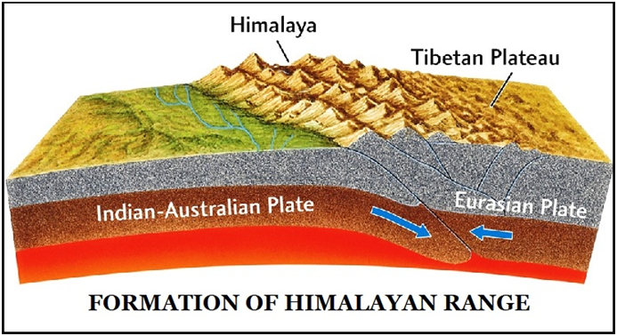
Major Physical Divisions of India : The Himalaya Mountain Ranges [Mapping] / भारत के प्रमुख भौतिक प्रभाग: हिमालय पर्वत श्रृंखलाएँ
- The Himalayan Mountains
- The Northern Plains
- The Peninsular Plateau
- The Indian Desert
- The Coastal Plains
- The Islands

The Himalayan Mountains


The Eastern Hills
Towards the region of Dihang Gorge, the Himalayas take a rapid southward turn and form a series of relatively low hills. Collectively, these hills are also called Purvanchal as they are located in the eastern part of India.
- Extent: They extend from Arunachal Pradesh in the north to Mizoram in the south. These hills constitute India’s border with Myanmar.
- Ranges:
- Patkai Bum– They are the northernmost range of Purvanchal. It forms the boundary between Arunachal Pradesh and Myanmar.
- Naga Hills – They lie to the south of Patkai Bum. They, along with Patkai Bum, form the watershed between India and Myanmar.
- Manipur Hills– They are situated to the south of Naga Hills. The Barail range splits the Naga Hills from the Manipur Hills.
- Mizo Hills or Lushai Hills– They lie to the south of Manipur Hills.
Regional Divisions of Himalayas
Based on longitudinal extent, the Himalayas has been divided into the following regional divisions:

- Punjab Himalayas
- It lies between the Indus river and Sutlej river. The majority of this region lies in the state of Jammu and Kashmir and Himachal Pradesh.
- Nearly, all the ranges such as Karakoram, Pir Panjal, Ladakh, Zaskar and Dhauladhar are prominent in this section. It is dominated by high snow covered mountains, deep gorges and high mountain passes.
- Kumaon Himalayas
- It is bounded by the Satluj and the Kali river. Several significant peaks such as Nanda Devi, Trisul, Kedarnath, Dunagiri, Kamet, Badrinath lie in this region. It is also known as Garhwal Himalayas in the west. This region is even more loftier when compared with Kashmir Himalayas. Major hill stations such as Nainital, Ranikhet and Almora lie in this region.
- Nepal Himalayas
- It stretches from Kali River in the west to Tista River in the east. A majority of this section lies in Nepal, therefore it is called Nepal Himalayas. This section is dominated by some of the tallest peaks of the world, including Mount Everest, Kanchenjunga, Dhaulagiri etc. Famous valley of Kathmandu is also located in this region.
- Assam Himalayas
- It is a sector of which lies between Tista and the Brahmaputra River. In India, it covers the states such as Assam and Arunachal Pradesh. However, this sector is much lower in elevation when compared to Nepal Himalayas.

- Namcha Barwa is the highest peak in this region. Other peaks include Gyala Peri, Kengto and Nyegyi Kangsang.
- They make a dramatic turn towards the south in the region of Arunachal Pradesh. Hence, ranges are arranged in the north-south trend in the north-eastern states.
Three Broad Divisions of Himalayas
Western Himalayas
- They spread over Jammu and Kashmir, Ladakh, Himachal Pradesh and Uttarakhand. It spreads over a distance of around 880 km between the Indus in the west and the Kali river in the east.
- It consists of three physiographic provinces:
- Kashmir Himalayas (Union Territories of Jammu and Kashmir)
- Himachal Himalayas (Himachal Pradesh)
- Kumaon Himalayas (Uttarakhand)
Prominent Peaks: Godwin Austin or K2.
2. Central Himalayas
They stretch for a distance of about 800 km between River Kali in the west and River Teesta in the east.
Prominent Peaks: Mt. Everest, Kanchenjunga, Makalu etc.
3. Eastern Himalayas
These lie between the Teesta river in the west and Brahmaputra river in the east, stretching for a distance of about 720 km.
Prominent Peaks: Namcha Barwa
Syntaxial Bends of the Himalayas
At its western and eastern extremities, the east-west trend of Himalayan ranges is suddenly terminated and the continuous range takes a sharp turn southwards, which are called Syntaxial Bends of the Himalayas. The bends on the western end are called the western syntaxical band and those at the eastern end are called the eastern syntaxical band.
- Western Syntaxical bend: It occurs near the Nanga Parbat where the River Indus cut the deep gorge.
- Eastern Syntaxical bend: It occurs at the eastern extremity of the Himalayas. This turn is visible prominently in Arunachal Pradesh around the Namcha Barwa, where the mountain ranges turn southwards after crossing the Brahmaputra.

Comparison of Western and Eastern Himalayas
| arameters | Western Himalayas | Eastern Himalayas |
| Extent | The Western Himalayan ranges lie between the Indus river in the west and the Kali river (Nepal) in the east. | The Eastern Himalayan range extends from the Tista river in the west to the easternmost extent of Himalayan ranges. |
| Gradient | In the portion of western Himalayan ranges, height is attained in the gradual succession as the mountains from the plains rise in a series of stages. Thus, the higher mountain ranges are far away from the plains. | The Eastern Himalayan ranges rise abruptly from the plains, thus peaks are not very far away from the plains such as Kanchenjunga. |
| Precipitation | The amount of rainfall in Western Himalayan ranges is less and is 1/4th of that of the Eastern Himalayan ranges.Western Himalayan ranges receive precipitation from north-west in the winters. | The Eastern Himalayan ranges face high rainfalls and they are covered with dense forests. The Eastern Himalayan ranges receive precipitation from south-west monsoon in the summers. |
| Vegetation | The alpine vegetation in Western Himalayan ranges is found up to 3000 m because of scant rainfall. The dominant vegetation in the Western Himalayan ranges is coniferous forests and alpine vegetation. | The alpine vegetation in Eastern Himalayan ranges is found up to 4000 m as a result of heavy rainfall. The vegetation in eastern Himalayan ranges consists of Sal forest and evergreen trees along with foothills, temperate broadleaf forests and alpine forest. |
| Biodiversity | Western Himalayan ranges lack biodiversity. | Eastern Himalayan ranges have huge biodiversity and are one of the Biodiversity Hotspots. Due to the presence of tropical evergreen forests there are high levels of biodiversity. |
Significance of Himalayas
- Climatic Influence: These ranges significantly affect the climate of India. Owing to their high altitude, length and direction, they effectively interrupt the summer monsoons coming from the Bay of Bengal and Arabian Sea and trigger precipitation in the form of rain or snow. It also prevents cold winter winds from the Siberian region from entering India.
- Security:These ranges have been protecting India from outside forces and intruders since ancient times thus serving as a defence barrier for India. In spite of development in modern warfare knowledge, the defence implication of these cannot be overlooked altogether.
- Perennial Source of Water:The majority of large rivers of India have their sources in the mountains of the Himalayan ranges. Plentiful rainfall and vast snow-fields in the form of glaciers act as a feeding grounds for the mighty rivers flowing in India. The Himalayan Rivers, along with hundreds of their tributaries, form the footing of life in the entire north India.
- Forest Wealth:They host the base of a rich forest which provides fuel wood and a huge diversity of raw materials for forest based industries. In addition, they also host a huge inventory of medicinal plants and herbs. Besides, they also provide rich pasture grounds for cattle rearing.
- Agriculture:Though the Himalayan ranges do not provide extensive plains for agricultural activities, some of the slopes have been terraced for the cultivation. Rice is one of the main crops on the terraced slopes. The other crops are wheat, maize, potatoes, tobacco and ginger. Tea is a distinctive crop, which can be exclusively grown on the hill slopes. It also sustains the horticulture sector by providing a wide variety of fruits such as apples, pears, grapes, walnuts, cherries, peaches, apricots, etc.
- Minerals:The Himalayan region provides many valuable minerals. There is huge potential for mineral oil in the tertiary rocks of the Himalayan ranges. Anthracite is a superior type of coal that is found in the Kalakot region of Kashmir. The various important minerals such as copper, lead, zinc, nickel, cobalt, antimony, tungsten, gold, silver, limestone, semi-precious and precious stones, gypsum and magnetite are known to occur at many locations.
- Hydroelectricity: These mountain ranges hold a huge potential for Hydroelectricity due to its fast flowing rivers. The rugged topography provides natural terrain for waterfalls at various places. Moreover, dams can also be constructed across rivers at some other places. The huge hydropower potential of the Himalayan rivers has not been explored fully.
भारत के प्रमुख भौतिक प्रभाग: हिमालय पर्वत श्रृंखलाएँ
- हिमालय पर्वत
- उत्तरी मैदान
- प्रायद्वीपीय पठार
- भारतीय रेगिस्तान
- तटीय मैदान
- द्वीप
हिमालय पर्वत
पूर्वी पहाड़ियाँ
- दिहांग गॉर्ज के क्षेत्र की ओर, हिमालय तेजी से दक्षिण की ओर मुड़ता है और अपेक्षाकृत कम पहाड़ियों की एक श्रृंखला बनाता है। सामूहिक रूप से, इन पहाड़ियों को पूर्वांचल भी कहा जाता है क्योंकि वे भारत के पूर्वी भाग में स्थित हैं।
- विस्तार: वे उत्तर में अरुणाचल प्रदेश से दक्षिण में मिजोरम तक फैले हुए हैं। ये पहाड़ियाँ म्यांमार के साथ भारत की सीमा बनाती हैं।
श्रेणियाँ:
- पटकाई बम – वे पूर्वांचल की सबसे उत्तरी श्रृंखला हैं। यह अरुणाचल प्रदेश और म्यांमार के बीच की सीमा बनाती है।
- नागा पहाड़ियाँ – वे पटकाई बम के दक्षिण में स्थित हैं। वे, पटकाई बम के साथ मिलकर भारत और म्यांमार के बीच जलविभाजक बनाते हैं।
- मणिपुर पहाड़ियाँ – वे नागा पहाड़ियों के दक्षिण में स्थित हैं
हिमालय के क्षेत्रीय प्रभाग
देशान्तरीय विस्तार के आधार पर हिमालय को निम्नलिखित क्षेत्रीय प्रभागों में विभाजित किया गया है:
पंजाब हिमालय
- यह सिंधु नदी और सतलुज नदी के बीच स्थित है। इस क्षेत्र का अधिकांश भाग जम्मू और कश्मीर और हिमाचल प्रदेश राज्य में स्थित है।
- लगभग सभी पर्वतमालाएँ जैसे कराकोरम, पीर पंजाल, लद्दाख, जास्कर और धौलाधार इस भाग में प्रमुख हैं। इसमें ऊँचे बर्फ से ढके पहाड़, गहरी घाटियाँ और ऊँचे पहाड़ी दर्रे हैं।
कुमाऊँ हिमालय
- यह सतलुज और काली नदी से घिरा है। नंदा देवी, त्रिशूल, केदारनाथ, दूनागिरी, कामेट, बद्रीनाथ जैसी कई महत्वपूर्ण चोटियाँ इस क्षेत्र में स्थित हैं। इसे पश्चिम में गढ़वाल हिमालय के नाम से भी जाना जाता है। कश्मीर हिमालय की तुलना में यह क्षेत्र और भी ऊँचा है। नैनीताल, रानीखेत और अल्मोड़ा जैसे प्रमुख हिल स्टेशन इसी क्षेत्र में स्थित हैं।
नेपाल हिमालय
- यह पश्चिम में काली नदी से लेकर पूर्व में तिस्ता नदी तक फैला हुआ है। इस भाग का अधिकांश भाग नेपाल में स्थित है, इसलिए इसे नेपाल हिमालय कहा जाता है। इस खंड में दुनिया की कुछ सबसे ऊंची चोटियाँ शामिल हैं, जिनमें माउंट एवरेस्ट, कंचनजंगा, धौलागिरी आदि शामिल हैं। काठमांडू की प्रसिद्ध घाटी भी इसी क्षेत्र में स्थित है।
असम हिमालय
- यह तिस्ता और ब्रह्मपुत्र नदी के बीच स्थित एक क्षेत्र है। भारत में, यह असम और अरुणाचल प्रदेश जैसे राज्यों को कवर करता है। हालाँकि, नेपाल हिमालय की तुलना में यह क्षेत्र ऊँचाई में बहुत कम है।
- नमचा बरवा इस क्षेत्र की सबसे ऊँची चोटी है। अन्य चोटियों में ग्याला पेरी, केंग्टो और न्येगी कांगसांग शामिल हैं।
- वे अरुणाचल प्रदेश के क्षेत्र में दक्षिण की ओर एक नाटकीय मोड़ लेते हैं। इसलिए, उत्तर-पूर्वी राज्यों में पर्वतमालाएँ उत्तर-दक्षिण प्रवृत्ति में व्यवस्थित हैं।
हिमालय के तीन व्यापक विभाजन
पश्चिमी हिमालय
- ये जम्मू और कश्मीर, लद्दाख, हिमाचल प्रदेश और उत्तराखंड में फैले हुए हैं। यह पश्चिम में सिंधु और पूर्व में काली नदी के बीच लगभग 880 किलोमीटर की दूरी तक फैला हुआ है।
- इसमें तीन भौगोलिक प्रांत शामिल हैं:
- कश्मीर हिमालय (जम्मू और कश्मीर केंद्र शासित प्रदेश)
- हिमाचल हिमालय (हिमाचल प्रदेश)
- कुमाऊँ हिमालय (उत्तराखंड)
प्रमुख चोटियाँ: गॉडविन ऑस्टिन या K2.
- मध्य हिमालय
वे पश्चिम में काली नदी और पूर्व में तीस्ता नदी के बीच लगभग 800 किमी की दूरी तक फैले हुए हैं।
प्रमुख चोटियाँ: माउंट एवरेस्ट, कंचनजंगा, मकालू आदि।
पूर्वी हिमालय
ये पश्चिम में तीस्ता नदी और पूर्व में ब्रह्मपुत्र नदी के बीच लगभग 720 किमी की दूरी तक फैले हुए हैं।
प्रमुख चोटियाँ: नमचा बरवा
हिमालय के वाक्यगत मोड़
अपने पश्चिमी और पूर्वी छोर पर, हिमालय पर्वतमाला की पूर्व-पश्चिम दिशा अचानक समाप्त हो जाती है और निरंतर श्रृंखला दक्षिण की ओर एक तीव्र मोड़ लेती है, जिसे हिमालय के वाक्यगत मोड़ कहा जाता है। पश्चिमी छोर पर मोड़ को पश्चिमी वाक्यगत बैंड कहा जाता है और पूर्वी छोर पर मोड़ को पूर्वी वाक्यगत बैंड कहा जाता है।
- पश्चिमी वाक्यगत मोड़: यह नंगा पर्वत के पास होता है जहाँ सिंधु नदी गहरी घाटी को काटती है।
- पूर्वी वाक्यविन्यासीय मोड़: यह हिमालय के पूर्वी छोर पर होता है। यह मोड़ अरुणाचल प्रदेश में नमचा बरवा के आसपास प्रमुखता से दिखाई देता है, जहाँ पर्वत श्रृंखलाएँ ब्रह्मपुत्र को पार करने के बाद दक्षिण की ओर मुड़ जाती हैं। पश्चिमी और पूर्वी हिमालय की तुलना
| पैरामीटर | पश्चिमी हिमालय | पूर्वी हिमालय |
| विस्तार | पश्चिमी हिमालय पर्वतमाला पश्चिम में सिंधु नदी और पूर्व में काली नदी (नेपाल) के बीच स्थित है। | पूर्वी हिमालय पर्वतमाला पश्चिम में तिस्ता नदी से लेकर हिमालय पर्वतमाला की सबसे पूर्वी सीमा तक फैली हुई है। |
| ढाल | पश्चिमी हिमालय पर्वतमाला के भाग में ऊँचाई क्रमिक क्रम में प्राप्त होती है क्योंकि मैदानों से पर्वत श्रृंखलाएँ कई चरणों में ऊपर उठती हैं। इस प्रकार, ऊँची पर्वत श्रृंखलाएँ मैदानों से बहुत दूर हैं। | पूर्वी हिमालय पर्वतमाला मैदानों से अचानक ऊपर उठती है, इसलिए कंचनजंगा जैसी चोटियां मैदानों से बहुत दूर नहीं हैं। |
| वर्षा | पश्चिमी हिमालय पर्वतमाला में वर्षा की मात्रा कम है और पूर्वी हिमालय पर्वतमाला की तुलना में 1/4 है।पश्चिमी हिमालय पर्वतमाला में सर्दियों में उत्तर-पश्चिम से वर्षा होती है। | पूर्वी हिमालय पर्वतमाला में भारी वर्षा होती है और वे घने जंगलों से आच्छादित हैं।पूर्वी हिमालय पर्वतमाला में गर्मियों में दक्षिण-पश्चिम मानसून से वर्षा होती है। |
| वनस्पति | पश्चिमी हिमालय पर्वतमाला में अल्प वर्षा के कारण अल्पाइन वनस्पति 3000 मीटर की ऊँचाई तक पाई जाती है।पश्चिमी हिमालय पर्वतमाला में प्रमुख वनस्पति शंकुधारी वन और अल्पाइन वनस्पति है। | पूर्वी हिमालय पर्वतमाला में अल्पाइन वनस्पति भारी वर्षा के परिणामस्वरूप 4000 मीटर की ऊँचाई तक पाई जाती है।पूर्वी हिमालय पर्वतमाला में वनस्पति में साल के जंगल और सदाबहार वृक्षों के साथ-साथ तलहटी, समशीतोष्ण चौड़ी पत्ती वाले वन और अल्पाइन वन शामिल हैं। |
| जैव विविधता | पश्चिमी हिमालय पर्वतमाला में जैव विविधता का अभाव है। | पूर्वी हिमालय पर्वतमाला में जैव विविधता बहुत अधिक है और यह जैव विविधता हॉटस्पॉट में से एक है। उष्णकटिबंधीय सदाबहार वनों की उपस्थिति के कारण यहाँ जैव विविधता का स्तर बहुत अधिक है। |
हिमालय का महत्व
- जलवायु प्रभाव: ये पर्वतमालाएँ भारत की जलवायु को महत्वपूर्ण रूप से प्रभावित करती हैं। अपनी ऊँचाई, लंबाई और दिशा के कारण, ये बंगाल की खाड़ी और अरब सागर से आने वाले ग्रीष्मकालीन मानसून को प्रभावी रूप से बाधित करती हैं और वर्षा या हिमपात के रूप में वर्षा को बढ़ावा देती हैं। यह साइबेरियाई क्षेत्र से आने वाली ठंडी सर्दियों की हवाओं को भारत में प्रवेश करने से भी रोकती हैं।
- सुरक्षा: ये पर्वतमालाएँ प्राचीन काल से ही बाहरी ताकतों और घुसपैठियों से भारत की रक्षा करती रही हैं और इस प्रकार भारत के लिए एक रक्षा अवरोध के रूप में कार्य करती रही हैं। आधुनिक युद्ध ज्ञान में विकास के बावजूद, इनके रक्षा निहितार्थ को पूरी तरह से नज़रअंदाज़ नहीं किया जा सकता है।
- जल का बारहमासी स्रोत: भारत की अधिकांश बड़ी नदियों का स्रोत हिमालय पर्वतमाला के पहाड़ों में है। प्रचुर वर्षा और ग्लेशियरों के रूप में विशाल हिम-क्षेत्र भारत में बहने वाली शक्तिशाली नदियों के लिए भोजन के मैदान के रूप में कार्य करते हैं। हिमालय की नदियाँ, अपनी सैकड़ों सहायक नदियों के साथ, पूरे उत्तर भारत में जीवन का आधार बनती हैं।
- वन संपदा: वे एक समृद्ध वन का आधार हैं जो ईंधन की लकड़ी और वन आधारित उद्योगों के लिए कच्चे माल की एक विशाल विविधता प्रदान करते हैं। इसके अलावा, वे औषधीय पौधों और जड़ी-बूटियों की एक विशाल सूची भी रखते हैं। इसके अलावा, वे मवेशी पालन के लिए समृद्ध चारागाह भी प्रदान करते हैं।
- कृषि: हालाँकि हिमालय पर्वतमाला कृषि गतिविधियों के लिए व्यापक मैदान प्रदान नहीं करती है, लेकिन कुछ ढलानों को खेती के लिए सीढ़ीदार बनाया गया है। सीढ़ीदार ढलानों पर चावल मुख्य फसलों में से एक है। अन्य फसलें गेहूं, मक्का, आलू, तंबाकू और अदरक हैं। चाय एक विशिष्ट फसल है, जिसे विशेष रूप से पहाड़ी ढलानों पर उगाया जा सकता है। यह सेब, नाशपाती, अंगूर, अखरोट, चेरी, आड़ू, खुबानी आदि जैसे फलों की एक विस्तृत विविधता प्रदान करके बागवानी क्षेत्र को भी बनाए रखता है।
- खनिज: हिमालयी क्षेत्र कई मूल्यवान खनिज प्रदान करता है। हिमालय पर्वतमाला की तृतीयक चट्टानों में खनिज तेल की अपार संभावना है। एन्थ्रेसाइट एक बेहतर प्रकार का कोयला है जो कश्मीर के कालाकोट क्षेत्र में पाया जाता है। तांबा, सीसा, जस्ता, निकल, कोबाल्ट, सुरमा, टंगस्टन, सोना, चांदी, चूना पत्थर, अर्ध-कीमती और कीमती पत्थर, जिप्सम और मैग्नेटाइट जैसे विभिन्न महत्वपूर्ण खनिज कई स्थानों पर पाए जाते हैं।
- जलविद्युत: इन पर्वत श्रृंखलाओं में अपनी तेज़ बहने वाली नदियों के कारण जलविद्युत की अपार संभावनाएँ हैं। ऊबड़-खाबड़ स्थलाकृति विभिन्न स्थानों पर झरनों के लिए प्राकृतिक भूभाग प्रदान करती है। इसके अलावा, कुछ अन्य स्थानों पर नदियों पर बांध भी बनाए जा सकते हैं। हिमालय की नदियों की विशाल जलविद्युत क्षमता का पूरी तरह से पता नहीं लगाया गया है।