
CURRENT AFFAIRS – 21/06/2024
- CURRENT AFFAIRS – 21/06/2024
- Karnataka govt. clears Centre’s proposal on reviving gold mining at Kolar Gold Fields / कर्नाटक सरकार ने कोलार गोल्ड फील्ड्स में सोने के खनन को पुनर्जीवित करने के केंद्र के प्रस्ताव को मंजूरी दी
- Bhartruhari Mahtab appointed protem Speaker of Lok Sabha / भर्तृहरि महताब को लोकसभा का प्रोटेम स्पीकर नियुक्त किया गया
- Limbless amphibian found in Kaziranga for first time / काजीरंगा में पहली बार अंगहीन उभयचर पाया गया
- The elderly are ailing, alone and struggling without the means to support themselves / बुजुर्ग बीमार हैं, अकेले हैं और खुद का भरण-पोषण करने के लिए संघर्ष कर रहे हैं
- Nagarhole Tiger Reserve / नागरहोल टाइगर रिजर्व
- The U.S.-Saudi agreement, from fist-bump to embrace / अमेरिका-सऊदी समझौता, मुट्ठी बांधने से लेकर गले मिलने तक
- Major Physical Divisions of India : The Himalaya Mountain Ranges [Mapping]/ भारत के प्रमुख भौतिक विभाग: हिमालय पर्वत श्रृंखलाएँ [मानचित्र]
CURRENT AFFAIRS – 21/06/2024
Karnataka govt. clears Centre’s proposal on reviving gold mining at Kolar Gold Fields / कर्नाटक सरकार ने कोलार गोल्ड फील्ड्स में सोने के खनन को पुनर्जीवित करने के केंद्र के प्रस्ताव को मंजूरी दी
Syllabus : Prelims Fact
- The Karnataka government approved the revival of gold mining at the historic Kolar Gold Fields (KGF), authorising the auction of 13 tailing dumps covering 1,003.4 acres by Bharat Gold Mines Ltd. (BGML).
About Kolar Gold Fields (KGF):
- Historical Significance: Kolar Gold Fields (KGF) is one of the oldest gold mines in India, dating back over 120 years.
- Location: Situated in the Kolar district of Karnataka, about 100 kilometers from Bangalore.
- Ownership: The mines are owned by Bharat Gold Mines Ltd. (BGML), a public sector undertaking established in 1972.
- Production Peak: During its peak, KGF was known as the deepest and richest gold mine in India, producing significant amounts of gold.
- Depth: The mines reached a depth of over 3 kilometers, making them some of the deepest in the world.
- Economic Impact: The mining operations at KGF provided employment and economic growth to the region for many decades.
- Closure: Mining operations ceased in 2001 due to a decline in gold production and rising costs.
- Revival Efforts: Recent proposals aim to revive gold extraction by processing 33 million tonnes of tailing dumps estimated to yield one gram of gold per tonne.
कर्नाटक सरकार ने कोलार गोल्ड फील्ड्स में सोने के खनन को पुनर्जीवित करने के केंद्र के प्रस्ताव को मंजूरी दी
- कर्नाटक सरकार ने ऐतिहासिक कोलार गोल्ड फील्ड्स (KGF) में सोने के खनन को पुनर्जीवित करने को मंजूरी दे दी है, तथा भारत गोल्ड माइंस लिमिटेड (BGML) द्वारा 1,003.4 एकड़ क्षेत्र में फैले 13 टेलिंग डंप की नीलामी को अधिकृत किया है।
कोलार गोल्ड फील्ड्स (KGF) के बारे में:
- ऐतिहासिक महत्व: कोलार गोल्ड फील्ड्स (KGF) भारत की सबसे पुरानी सोने की खदानों में से एक है, जो 120 साल से भी ज़्यादा पुरानी है।
- स्थान: कर्नाटक के कोलार जिले में स्थित, बैंगलोर से लगभग 100 किलोमीटर दूर।
- स्वामित्व: खदानों का स्वामित्व भारत गोल्ड माइंस लिमिटेड (BGML) के पास है, जो 1972 में स्थापित एक सार्वजनिक क्षेत्र का उपक्रम है।
- उत्पादन का चरम: अपने चरम के दौरान, KGF को भारत की सबसे गहरी और सबसे समृद्ध सोने की खदान के रूप में जाना जाता था, जो महत्वपूर्ण मात्रा में सोने का उत्पादन करती थी।
- गहराई: खदानें 3 किलोमीटर से ज़्यादा गहरी थीं, जो उन्हें दुनिया की सबसे गहरी खदानों में से एक बनाती हैं।
- आर्थिक प्रभाव: KGF में खनन कार्यों ने कई दशकों तक इस क्षेत्र को रोज़गार और आर्थिक विकास प्रदान किया।
- बंद होना: सोने के उत्पादन में गिरावट और बढ़ती लागत के कारण 2001 में खनन कार्य बंद हो गए।
- पुनरुद्धार प्रयास: हाल के प्रस्तावों का उद्देश्य 33 मिलियन टन टेलिंग डम्प का प्रसंस्करण करके सोने के निष्कर्षण को पुनर्जीवित करना है, जिससे प्रति टन एक ग्राम सोना प्राप्त होने का अनुमान है।
Bhartruhari Mahtab appointed protem Speaker of Lok Sabha / भर्तृहरि महताब को लोकसभा का प्रोटेम स्पीकर नियुक्त किया गया
(General Studies- Paper II)
Source : The Hindu
President Droupadi Murmu appointed Bhartruhari Mahtab as the pro tem Speaker of the 18th Lok Sabha, which stirred controversy as Opposition leaders argued that the senior-most MP, Kodikunnil Suresh, was overlooked for this customary role.
Pro-tem Speaker:
- Appointment: Appointed by the President based on convention or recommendation from the ruling party.
- Role: Conducts the oath or affirmation ceremony of newly elected members.
- Duties: Presides over the election of the regular Speaker and facilitates the smooth functioning of the House until a Speaker is elected.
- Duration: Usually serves until a permanent Speaker is elected by the members of the legislative body.
- Seniority: Often appointed based on seniority or parliamentary experience, though political considerations and consensus play a significant role.
- Powers: Exercises similar powers as a regular Speaker during their tenure, ensuring parliamentary rules are followed and maintaining order.
भर्तृहरि महताब को लोकसभा का प्रोटेम स्पीकर नियुक्त किया गया
राष्ट्रपति द्रौपदी मुर्मू ने भर्तृहरि महताब को 18वीं लोकसभा का अस्थायी अध्यक्ष नियुक्त किया, जिससे विवाद खड़ा हो गया, क्योंकि विपक्षी नेताओं ने तर्क दिया कि इस पारंपरिक भूमिका के लिए सबसे वरिष्ठ सांसद कोडिकुन्निल सुरेश की अनदेखी की गई।
प्रोटेम स्पीकर:
- नियुक्ति: राष्ट्रपति द्वारा सत्तारूढ़ दल की परंपरा या सिफारिश के आधार पर नियुक्त किया जाता है।
- भूमिका: नव निर्वाचित सदस्यों के शपथ या प्रतिज्ञान समारोह का आयोजन करता है।
- कर्तव्य: नियमित अध्यक्ष के चुनाव की अध्यक्षता करता है और अध्यक्ष के निर्वाचित होने तक सदन के सुचारू संचालन में सहायता करता है।
- अवधि: आमतौर पर तब तक कार्य करता है जब तक विधायी निकाय के सदस्यों द्वारा स्थायी अध्यक्ष का चुनाव नहीं हो जाता।
- वरिष्ठता: अक्सर वरिष्ठता या संसदीय अनुभव के आधार पर नियुक्त किया जाता है, हालांकि राजनीतिक विचार और आम सहमति महत्वपूर्ण भूमिका निभाती है।
- शक्तियाँ: अपने कार्यकाल के दौरान नियमित अध्यक्ष के समान शक्तियों का प्रयोग करता है, यह सुनिश्चित करता है कि संसदीय नियमों का पालन हो और व्यवस्था बनी रहे।
Limbless amphibian found in Kaziranga for first time / काजीरंगा में पहली बार अंगहीन उभयचर पाया गया
(General Studies- Paper III)
Source : The Hindu
A limbless amphibian, the striped caecilian (Ichthyophis spp), has been newly identified within the 1,307.49 sq. km Kaziranga National Park and Tiger Reserve.
- Assam’s wildlife officials reported its discovery during a herpetofauna survey.
- This limbless amphibian was discovered during a rapid survey conducted by herpetologists from June 14-17.
- The park’s ecosystem, including flood plains, wetlands, grasslands, and hills, provides an ideal habitat for diverse herpetofauna.
- Kaziranga is known for its rich biodiversity, hosting 24 amphibian species and 74 reptile species, including 21 out of 29 species of Indian tortoises and freshwater turtles.
- Caecilians are ancient and poorly studied amphibians that primarily live underground.
- The discovery underscores the park’s importance for conservation, especially amidst climate change challenges.
About Kaziranga National Park:
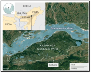
| Details | |
| Location | Assam, India |
| Geographical Features | Situated between Brahmaputra River and Karbi (Mikir) Hills |
| Significance | Eastern Himalayan Biodiversity Hotspot |
| Rivers | Diphlu River runs through the park |
| Highways | National Highway 37 passes through the park |
| Legal Status | · Designated as a National Park in 1974. · UNESCO World Heritage Site (1985).· Important Bird Area by Birdlife International |
| Key Conservation Achievements | · Houses around 2/3rd of the world’s Great Indian One-Horned Rhinoceros. · Declared a Tiger Reserve due to high tiger density |
| ‘Big Five’ species | Great Indian One-Horned Rhino, Asian Elephant, Royal Bengal Tiger, Asiatic Water Buffalo, Swamp Deer |
| Aquatic Species | Gangetic River Dolphin |
| Vegetation | Wet Alluvial Grasslands, Tropical Moist Deciduous Forests, Semi-EvergreenForests |
काजीरंगा में पहली बार अंगहीन उभयचर पाया गया
1,307.49 वर्ग किलोमीटर के काजीरंगा राष्ट्रीय उद्यान और टाइगर रिजर्व में एक अंगहीन उभयचर, धारीदार सीसिलियन (इचथियोफिस SPP) की हाल ही में पहचान की गई है।
- असम के वन्यजीव अधिकारियों ने एक हर्पेटोफौना सर्वेक्षण के दौरान इसकी खोज की सूचना दी।
- इस अंगहीन उभयचर की खोज 14-17 जून के बीच सरीसृप विज्ञानियों द्वारा किए गए एक त्वरित सर्वेक्षण के दौरान की गई थी।
- पार्क का पारिस्थितिकी तंत्र, जिसमें बाढ़ के मैदान, आर्द्रभूमि, घास के मैदान और पहाड़ियाँ शामिल हैं, विविध सरीसृप जीवों के लिए एक आदर्श आवास प्रदान करता है।
- काजीरंगा अपनी समृद्ध जैव विविधता के लिए जाना जाता है, जिसमें 24 उभयचर प्रजातियाँ और 74 सरीसृप प्रजातियाँ हैं, जिनमें भारतीय कछुओं और मीठे पानी के कछुओं की 29 प्रजातियों में से 21 शामिल हैं।
- सीसिलियन प्राचीन और कम अध्ययन किए गए उभयचर हैं जो मुख्य रूप से भूमिगत रहते हैं।
- यह खोज संरक्षण के लिए पार्क के महत्व को रेखांकित करती है, खासकर जलवायु परिवर्तन की चुनौतियों के बीच।
काजीरंगा राष्ट्रीय उद्यान के बारे में:
| विवरण | |
| स्थान | असम, भारत |
| भौगोलिक विशेषताएँ | ब्रह्मपुत्र नदी और कार्बी (मिकिर) पहाड़ियों के बीच स्थित |
| महत्व | पूर्वी हिमालयी जैव विविधता हॉटस्पॉट |
| नदियाँ | डिफ्लू नदी पार्क से होकर गुजरती है |
| राजमार्ग | राष्ट्रीय राजमार्ग 37 पार्क से होकर गुजरता है |
| कानूनी स्थिति | • 1974 में राष्ट्रीय उद्यान के रूप में नामित।• यूनेस्को विश्व धरोहर स्थल (1985)।• बर्डलाइफ इंटरनेशनल द्वारा महत्वपूर्ण पक्षी क्षेत्र |
| प्रमुख संरक्षण उपलब्धियाँ | • दुनिया के लगभग 2/3 महान भारतीय एक सींग वाले गैंडे यहाँ रहते हैं।• बाघों की उच्च घनत्व के कारण इसे टाइगर रिजर्व घोषित किया गया है |
| ‘बिग फाइव’ प्रजातियाँ | महान भारतीय एक सींग वाला गैंडा, एशियाई हाथी, रॉयल बंगाल टाइगर, एशियाई जल भैंसा, दलदली हिरण |
| जलीय प्रजातियाँ | गंगा नदी डॉल्फिन |
| वनस्पति | आर्द्र जलोढ़ घास का मैदान, उष्णकटिबंधीय नम पर्णपाती वन, अर्ध-सदाबहार वन |
The elderly are ailing, alone and struggling without the means to support themselves / बुजुर्ग बीमार हैं, अकेले हैं और खुद का भरण-पोषण करने के लिए संघर्ष कर रहे हैं
(General Studies- Paper II)
Source : The Hindu
HelpAge India’s survey of over 5,000 elders and 1,300 caregivers across 20 cities in 10 states reveals stark realities.Only 15% of elders have income, 79% rely on government hospitals, and 31% possess health insurance.
- HelpAge India conducted a survey across 10 states and 20 cities, interviewing 5,169 elders and 1,333 caregivers.
- Only 15% of elders had a source of income; among them, 24% were men and 7% were women.
- 29% relied on financial support from their children.
- 79% used government hospitals, while only 31% had health insurance.
- Awareness of exclusive geriatric facilities was low at 15%.
- Social security coverage, including pensions and provident funds, was reported by 29%.
- 54% of elders had two or more non-communicable diseases (NCDs), with high rates of hypertension (48%) and diabetes (43%).
- Caregivers faced physical and financial challenges, with only 7% involved in social organisations.
- Calls were made for state-level elder policies based on survey findings, emphasising the need for better support and facilities.
बुजुर्ग बीमार हैं, अकेले हैं और खुद का भरण-पोषण करने के लिए संघर्ष कर रहे हैं
हेल्पएज इंडिया द्वारा 10 राज्यों के 20 शहरों में 5,000 से अधिक बुजुर्गों और 1,300 देखभालकर्ताओं के बीच किए गए सर्वेक्षण से कठोर वास्तविकताएं सामने आई हैं। केवल 15% बुजुर्गों के पास आय है, 79% सरकारी अस्पतालों पर निर्भर हैं, और 31% के पास स्वास्थ्य बीमा है।
- हेल्पएज इंडिया ने 10 राज्यों और 20 शहरों में एक सर्वेक्षण किया, जिसमें 5,169 बुजुर्गों और 1,333 देखभाल करने वालों का साक्षात्कार लिया गया।
- केवल 15% बुजुर्गों के पास आय का स्रोत था; उनमें से 24% पुरुष और 7% महिलाएँ थीं।
- 29% अपने बच्चों से मिलने वाली वित्तीय सहायता पर निर्भर थे।
- 79% ने सरकारी अस्पतालों का इस्तेमाल किया, जबकि केवल 31% के पास स्वास्थ्य बीमा था।
- विशेष वृद्धावस्था सुविधाओं के बारे में जागरूकता 15% पर कम थी।
- पेंशन और भविष्य निधि सहित सामाजिक सुरक्षा कवरेज की रिपोर्ट 29% ने दी।
- 54% बुजुर्गों को दो या अधिक गैर-संचारी रोग (एनसीडी) थे, जिनमें उच्च रक्तचाप (48%) और मधुमेह (43%) की दर अधिक थी।
- देखभाल करने वालों को शारीरिक और वित्तीय चुनौतियों का सामना करना पड़ा, जिनमें से केवल 7% सामाजिक संगठनों में शामिल थे।
- सर्वेक्षण निष्कर्षों के आधार पर राज्य-स्तरीय बुजुर्ग नीतियों के लिए आह्वान किया गया, जिसमें बेहतर समर्थन और सुविधाओं की आवश्यकता पर जोर दिया गया।
Nagarhole Tiger Reserve / नागरहोल टाइगर रिजर्व
Prelims Fact : Location In News
Ashwatthama, a 38-year-old elephant, died of electrocution near Karnataka’s Nagarahole Tiger Reserve.
- The High Court of Karnataka suo motu initiated a PIL petition to inquire about this incident attributed to a lack of care and diligence by concerned authorities.

Nagarahole Tiger Reserve
- Located in the Western Ghats in Karnataka; Spans over 643 square kilometers.
- Declared a wildlife sanctuary in 1955 and a tiger reserve in 1999.
- Part of the Nilgiri Biosphere Reserve is recognised as an Important Bird Area (IBA) and a Project Tiger, Project Elephant reserve.
- Managed by the Karnataka Forest Department with efforts focused on conservation, ecotourism, and community engagement.
- The reserve is crisscrossed by several rivers such as the Kabini River, Lakshmana Tirtha River, and Moyar River.
- Flora and Fauna: Known for its diverse ecosystem, including tropical and moist deciduous forests, home to a variety of wildlife such as tigers, leopards, elephants, gaur, and several species of deer and birds.
Status of Elephant Conservation in India
| Details | |
| Population Estimate | · India hosts the largest population of wild Asian Elephants (Elephas maximus), with around 29,964 individuals, · Approximately 60% of the global population (2017 census). |
| Leading States | Karnataka holds the highest number of elephants, followed by Assam and Kerala. |
| Conservation Status | · IUCN Red List: Endangered. · CMS: Appendix I. · Wildlife (Protection) Act, 1972: Listed under Schedule I, · CITES: Appendix I. |
नागरहोल टाइगर रिजर्व
कर्नाटक के नागरहोल टाइगर रिजर्व के पास 38 वर्षीय हाथी अश्वत्थामा की बिजली का झटका लगने से मौत हो गई।
- कर्नाटक उच्च न्यायालय ने इस घटना के बारे में पूछताछ करने के लिए स्वतः संज्ञान लेते हुए एक जनहित याचिका दायर की, जिसमें संबंधित अधिकारियों द्वारा लापरवाही और तत्परता की कमी को जिम्मेदार ठहराया गया।
नागरहोल टाइगर रिजर्व
- कर्नाटक के पश्चिमी घाट में स्थित; 643 वर्ग किलोमीटर में फैला हुआ है।
- 1955 में वन्यजीव अभयारण्य और 1999 में बाघ अभयारण्य घोषित किया गया।
- नीलगिरी बायोस्फीयर रिजर्व का एक हिस्सा एक महत्वपूर्ण पक्षी क्षेत्र (आईबीए) और एक प्रोजेक्ट टाइगर, प्रोजेक्ट एलीफेंट रिजर्व के रूप में मान्यता प्राप्त है।
- कर्नाटक वन विभाग द्वारा संरक्षण, इकोटूरिज्म और सामुदायिक जुड़ाव पर केंद्रित प्रयासों के साथ प्रबंधित किया जाता है।
- रिजर्व में कई नदियाँ जैसे काबिनी नदी, लक्ष्मण तीर्थ नदी और मोयार नदी बहती हैं।
- वनस्पति और जीव: उष्णकटिबंधीय और नम पर्णपाती जंगलों सहित अपने विविध पारिस्थितिकी तंत्र के लिए जाना जाता है, जो बाघ, तेंदुए, हाथी, गौर और हिरण और पक्षियों की कई प्रजातियों जैसे विभिन्न वन्यजीवों का घर है।
भारत में हाथी संरक्षण की स्थिति
| Details | |
| जनसंख्या अनुमान | • भारत में जंगली एशियाई हाथियों (एलिफस मैक्सिमस) की सबसे बड़ी आबादी है, जिनकी संख्या लगभग 29,964 है, • वैश्विक आबादी का लगभग 60% (2017 की जनगणना)। |
| अग्रणी राज्य | कर्नाटक में हाथियों की संख्या सबसे अधिक है, उसके बाद असम और केरल का स्थान है। |
| संरक्षण स्थिति | • IUCN रेड लिस्ट: संकटग्रस्त।• CMS: परिशिष्ट I.• वन्यजीव (संरक्षण) अधिनियम, 1972: अनुसूची I के अंतर्गत सूचीबद्ध,• CITES: परिशिष्ट I. |
The U.S.-Saudi agreement, from fist-bump to embrace / अमेरिका-सऊदी समझौता, मुट्ठी बांधने से लेकर गले मिलने तक
(General Studies- Paper II)
Source : The Hindu
Context : The United States and Saudi Arabia are negotiating a Strategic Alliance Agreement (SAA) aimed at formalising their defence and economic ties. This potential agreement seeks to align Saudi Arabia’s regional ambitions with U.S. diplomatic goals, particularly in response to China’s growing influence in the region.
Historical Context
- The United States and the Kingdom of Saudi Arabia have had a complex relationship over the past eight decades, marked by significant events like the oil embargo of 1973 and the Jamal Khashoggi assassination in 2018.
- Two iconic images symbolise this relationship: the 1945 meeting between U.S. President Franklin D. Roosevelt and King Abdul Aziz Al-Saud, and the 2022 fist-bump between U.S. President Joe Biden and Crown Prince Mohammed bin Salman (MbS).
The Layers to the Agreement
The Emerging Strategic Alliance Agreement (SAA)
- The United States and Saudi Arabia are negotiating a Strategic Alliance Agreement (SAA), aiming to match Saudi Arabia’s regional ambitions with the United States’ diplomatic goals.
- The SAA is designed to address bilateral, regional, and global aspects of the relationship.
Bilateral Relations
- The SAA may codify the bilateral alliance into a strategic defence pact, similar to the U.S.-Japan treaty, ensuring the United States’ commitment to Saudi Arabia’s defence.
- The United States might provide Saudi Arabia with advanced defence technology, including F-35 stealth fighters and nuclear technology for peaceful purposes.
Regional Impacts
- Saudi Arabia seeks a ceasefire in Gaza and progress towards a two-state solution to the Israel-Palestine conflict.
- The United States wants Saudi Arabia to recognize Israel and establish full diplomatic relations, and to limit its foreign policy engagements with Beijing and Moscow.
Economic Components
- Despite the United States’ reduced dependence on Saudi oil, both countries are expected to maintain coordination to balance global energy markets.
- The SAA could ensure that American companies receive substantial portions of projects under Saudi Arabia’s Vision 2030.
Catalysts and Strategic Implications
- China’s increasing influence in Saudi Arabia, exemplified by President Xi Jinping’s state visit to Riyadh in December 2022, prompted the United States to strengthen its ties with Saudi Arabia.
- Saudi Arabia’s recognition of Israel could significantly alter the geopolitical landscape in West Asia and influence the broader Islamic world.
Bilateral Trust Deficit
- A significant trust deficit has emerged between the United States and Saudi Arabia over the past decade, exacerbated by perceived U.S. ambivalence towards Iran and inconsistent support during regional conflicts.
Gaza Conflict
- The ongoing Gaza conflict complicates Saudi Arabia’s potential reconciliation with Israel, which is crucial for the SAA’s approval by the U.S. Senate.
Geopolitical Tensions
- A successful SAA could reinforce U.S. influence (Pax Americana) in the Gulf and West Asia, boost pro-West regimes, and diminish the Palestinian cause.
- Failure to achieve the SAA could result in continued regional instability, with non-state actors disrupting equilibrium and the region remaining contested by external powers.
- A partial agreement may emerge if a comprehensive SAA is unattainable, involving other friendly countries to fill gaps.
India’s Stakes
- Regional Stability : India, as a significant regional player, should monitor the evolving Strategic Alliance Agreement (SAA) closely.
- Economic Opportunities : A successful SAA could enhance regional stability, create economic opportunities, and support the India-Middle East-Europe Economic Corridor.
- Strategic Policy : India should continue its “Act West” policy independently, ensuring readiness for any developments in the Saudi-Israeli relationship.
अमेरिका-सऊदी समझौता, मुट्ठी बांधने से लेकर गले मिलने तक
प्रसंग: संयुक्त राज्य अमेरिका और सऊदी अरब अपने रक्षा और आर्थिक संबंधों को औपचारिक रूप देने के उद्देश्य से एक रणनीतिक गठबंधन समझौते (एसएए) पर बातचीत कर रहे हैं। यह संभावित समझौता सऊदी अरब की क्षेत्रीय महत्वाकांक्षाओं को अमेरिकी कूटनीतिक लक्ष्यों के साथ संरेखित करने का प्रयास करता है, विशेष रूप से क्षेत्र में चीन के बढ़ते प्रभाव के जवाब में।
ऐतिहासिक संदर्भ
- पिछले आठ दशकों में संयुक्त राज्य अमेरिका और सऊदी अरब के बीच जटिल संबंध रहे हैं, जिनमें 1973 के तेल प्रतिबंध और 2018 में जमाल खशोगी की हत्या जैसी महत्वपूर्ण घटनाएँ शामिल हैं।
- दो प्रतिष्ठित छवियाँ इस संबंध का प्रतीक हैं: 1945 में अमेरिकी राष्ट्रपति फ्रैंकलिन डी. रूजवेल्ट और किंग अब्दुल अजीज अल-सऊद के बीच की मुलाकात और 2022 में अमेरिकी राष्ट्रपति जो बिडेन और क्राउन प्रिंस मोहम्मद बिन सलमान (एमबीएस) के बीच मुक्का-टक्कर।
समझौते की परतें
उभरता हुआ रणनीतिक गठबंधन समझौता (SAA)
- संयुक्त राज्य अमेरिका और सऊदी अरब एक रणनीतिक गठबंधन समझौते (SAA) पर बातचीत कर रहे हैं, जिसका उद्देश्य सऊदी अरब की क्षेत्रीय महत्वाकांक्षाओं को संयुक्त राज्य अमेरिका के कूटनीतिक लक्ष्यों के साथ मिलाना है।
- SAA को संबंधों के द्विपक्षीय, क्षेत्रीय और वैश्विक पहलुओं को संबोधित करने के लिए डिज़ाइन किया गया है।
द्विपक्षीय संबंध
- एसएए द्विपक्षीय गठबंधन को यू.एस.-जापान संधि के समान रणनीतिक रक्षा समझौते में संहिताबद्ध कर सकता है, जिससे सऊदी अरब की रक्षा के लिए संयुक्त राज्य अमेरिका की प्रतिबद्धता सुनिश्चित होगी।
- संयुक्त राज्य अमेरिका सऊदी अरब को शांतिपूर्ण उद्देश्यों के लिए F-35 स्टील्थ फाइटर्स और परमाणु प्रौद्योगिकी सहित उन्नत रक्षा प्रौद्योगिकी प्रदान कर सकता है।
क्षेत्रीय प्रभाव
- सऊदी अरब गाजा में युद्ध विराम और इजरायल-फिलिस्तीन संघर्ष के लिए दो-राज्य समाधान की दिशा में प्रगति चाहता है।
- संयुक्त राज्य अमेरिका चाहता है कि सऊदी अरब इजरायल को मान्यता दे और पूर्ण राजनयिक संबंध स्थापित करे, और बीजिंग और मॉस्को के साथ अपनी विदेश नीति की व्यस्तताओं को सीमित करे।
आर्थिक घटक
- सऊदी तेल पर संयुक्त राज्य अमेरिका की कम निर्भरता के बावजूद, दोनों देशों से वैश्विक ऊर्जा बाजारों को संतुलित करने के लिए समन्वय बनाए रखने की उम्मीद है।
- एसएए यह सुनिश्चित कर सकता है कि अमेरिकी कंपनियों को सऊदी अरब के विज़न 2030 के तहत परियोजनाओं का पर्याप्त हिस्सा मिले।
उत्प्रेरक और रणनीतिक निहितार्थ
- सऊदी अरब में चीन के बढ़ते प्रभाव, जिसका उदाहरण दिसंबर 2022 में राष्ट्रपति शी जिनपिंग की रियाद की राजकीय यात्रा है, ने संयुक्त राज्य अमेरिका को सऊदी अरब के साथ अपने संबंधों को मजबूत करने के लिए प्रेरित किया।
- सऊदी अरब द्वारा इजरायल को मान्यता देने से पश्चिम एशिया में भू-राजनीतिक परिदृश्य में महत्वपूर्ण बदलाव आ सकता है और व्यापक इस्लामी दुनिया पर इसका प्रभाव पड़ सकता है।
द्विपक्षीय विश्वास घाटा
- पिछले एक दशक में संयुक्त राज्य अमेरिका और सऊदी अरब के बीच एक महत्वपूर्ण विश्वास घाटा उभरा है, जो ईरान के प्रति कथित अमेरिकी द्विपक्षीयता और क्षेत्रीय संघर्षों के दौरान असंगत समर्थन से और बढ़ गया है।
गाजा संघर्ष
- चल रहा गाजा संघर्ष सऊदी अरब के इजरायल के साथ संभावित सुलह को जटिल बनाता है, जो अमेरिकी सीनेट द्वारा एसएए की मंजूरी के लिए महत्वपूर्ण है।
भू-राजनीतिक तनाव
- एक सफल SAA खाड़ी और पश्चिम एशिया में अमेरिकी प्रभाव (पैक्स अमेरिकाना) को मजबूत कर सकता है, पश्चिम समर्थक शासन को बढ़ावा दे सकता है, और फिलिस्तीनी कारण को कम कर सकता है।
- SAA को प्राप्त करने में विफलता के परिणामस्वरूप निरंतर क्षेत्रीय अस्थिरता हो सकती है, जिसमें गैर-राज्य अभिनेता संतुलन को बाधित कर सकते हैं और क्षेत्र बाहरी शक्तियों द्वारा विवादित बना रह सकता है।
- यदि व्यापक SAA अप्राप्य है, तो अंतराल को भरने के लिए अन्य मित्र देशों को शामिल करते हुए आंशिक समझौता हो सकता है।
भारत के दांव
- क्षेत्रीय स्थिरता: एक महत्वपूर्ण क्षेत्रीय खिलाड़ी के रूप में भारत को विकसित हो रहे रणनीतिक गठबंधन समझौते (SAA) की बारीकी से निगरानी करनी चाहिए।
- आर्थिक अवसर: एक सफल SAA क्षेत्रीय स्थिरता को बढ़ा सकता है, आर्थिक अवसर पैदा कर सकता है, और भारत-मध्य पूर्व-यूरोप आर्थिक गलियारे का समर्थन कर सकता है।
- रणनीतिक नीति: भारत को सऊदी-इज़राइल संबंधों में किसी भी विकास के लिए तत्परता सुनिश्चित करते हुए अपनी “एक्ट वेस्ट” नीति को स्वतंत्र रूप से जारी रखना चाहिए।
Major Physical Divisions of India : The Himalaya Mountain Ranges [Mapping]/ भारत के प्रमुख भौतिक विभाग: हिमालय पर्वत श्रृंखलाएँ [मानचित्र]
- The Himalayan Mountains
- The Northern Plains
- The Peninsular Plateau
- The Indian Desert
- The Coastal Plains
- The Islands

1. The Himalayan Mountains

The Himalayan Mountains stand as a grand barrier guarding India’s frontiers against both cold winds arising from central Asia and foreign invasions from the central Asian rulers.
Additionally, they also act as a dividing range between the Tibetan Plateau in the North and the Alluvial Plains towards the South of it.
Along with acting as a water divide between Indo-Gangetic and Tibetan river systems, they also act as a cultural divide. The Himalayan range comprises a number of peaks and valleys. The world’s tallest mountain Mt. Everest is part of Himalayan range located in Nepal. A number of valleys like the Mussorie, Kashmir valley serve as residential areas as well as touristic destinations.
Formation of Himalayas
The origin of the Himalayan mountain range goes back several million years ago. Their formation is the result of a collision of two massive tectonic plates consisting of the Indian plate with the Eurasian (Asian) plate along the convergent boundary. The following series of events led to their genesis:

- Existence of Pangea and Panthalassa: The process started250 million years ago. There existed a supercontinent called Pangea which was surrounded by a massive water body called Panthalassa.
- Breaking of Pangea: Around 150 million years ago the supercontinent Pangea began to break into different parts.
- Laurasia or Angaraland: In the first place Pangea was divided into two parts. The northern part of the Pangea was called Angaraland or Laurasia. It consisted of landmasses which contained present-day North America, Europe and Asia.
- Formation of Gondwana land: The southern part of the Pangea is called Gondwanaland. It consisted of the present-day South America, Africa, South India, Australia and Antarctica.
- Formation of Tethys Sea: Due to the breaking down of Pangea, a long narrow seawas created between Angaraland and Gondwanaland. This sea was known as the Tethys Sea and it occupied the area of the prevailing mountains. During the course of time huge amounts of sediments were deposited in the bed of the sea by the rivers from two landmasses.
- Breaking down of Gondwanaland: The Gondwanaland was further broken down into different smaller landmasses.
- Drift of Indo-Australian tectonic plate towards the north: The Indo-Australian tectonic plate which contained the continents of Australia and the Indian subcontinent drifted towards north by the convection currents generated in the Mantle of the Earth. For millions of years, India drifted across the sea toward the Eurasian plates (a portion of Angaraland).

- Shrinkage of Tethys Sea and formation of folds: Asthe Indian plate approached Asia, the area of the Tethys Sea began to shrink and the sediments in its seabed were slowly pushed upwards which led to the formation of folds. When the plate containing India and the plate containing Tibet collided, instead of descending with the plate, the comparatively light sedimentary rocks that make up the subcontinent of India pushed against Tibet and forced it upwards. This event led to the creation of one of the highest relief features on the Earth – The Himalayas.
- Formation of Islands: The Andaman and Nicobar Island chainin the Bay of Bengal and the Arakan Yoma in Myanmar were created as a consequence of this collision activity.
Division of Himalayas
On the basis of the latitudinal extent, the Himalayas can be divided into three divisions as follows:
1. Trans-Himalayas. 2.The Himalayan Mountain Ranges. 3. The Eastern Hills or Purvanchal.

भारत के प्रमुख भौतिक विभाग: हिमालय पर्वत श्रृंखलाएँ [मानचित्र]
- हिमालय पर्वत
- उत्तरी मैदान
- प्रायद्वीपीय पठार
- भारतीय रेगिस्तान
- तटीय मैदान
- द्वीप
1. हिमालय पर्वत
हिमालय पर्वत भारत की सीमाओं की रक्षा करने वाले एक विशाल अवरोधक के रूप में खड़ा है, जो मध्य एशिया से आने वाली ठंडी हवाओं और मध्य एशियाई शासकों के विदेशी आक्रमणों से बचाता है।
इसके अतिरिक्त, वे उत्तर में तिब्बती पठार और उसके दक्षिण में जलोढ़ मैदानों के बीच एक विभाजन रेखा के रूप में भी कार्य करते हैं।
भारत-गंगा और तिब्बती नदी प्रणालियों के बीच जल विभाजक के रूप में कार्य करने के साथ-साथ, वे एक सांस्कृतिक विभाजन के रूप में भी कार्य करते हैं। हिमालय पर्वत श्रृंखला में कई चोटियाँ और घाटियाँ शामिल हैं। दुनिया का सबसे ऊँचा पर्वत माउंट एवरेस्ट नेपाल में स्थित हिमालय पर्वत श्रृंखला का हिस्सा है। मसूरी, कश्मीर घाटी जैसी कई घाटियाँ आवासीय क्षेत्रों के साथ-साथ पर्यटन स्थलों के रूप में भी काम करती हैं।
हिमालय का निर्माण
हिमालय पर्वत श्रृंखला की उत्पत्ति कई मिलियन वर्ष पहले हुई थी। उनका निर्माण दो विशाल टेक्टोनिक प्लेटों के टकराव का परिणाम है, जिसमें भारतीय प्लेट और यूरेशियन (एशियाई) प्लेट अभिसारी सीमा पर शामिल हैं। निम्नलिखित घटनाओं की श्रृंखला ने उनकी उत्पत्ति को जन्म दिया:
- पैंजिया और पंथालासा का अस्तित्व: यह प्रक्रिया 250 मिलियन वर्ष पहले शुरू हुई थी। पैंजिया नामक एक महाद्वीप था जो पंथालासा नामक एक विशाल जल निकाय से घिरा हुआ था।
- पैंजिया का टूटना: लगभग 150 मिलियन वर्ष पहले महाद्वीप पैंजिया अलग-अलग भागों में टूटना शुरू हुआ।
- लॉरेशिया या अंगारालैंड: सबसे पहले पैंजिया दो भागों में विभाजित हुआ। पैंजिया के उत्तरी भाग को अंगारालैंड या लॉरेशिया कहा जाता था। इसमें वर्तमान उत्तरी अमेरिका, यूरोप और एशिया के भूभाग शामिल थे।
- गोंडवाना भूमि का निर्माण: पैंजिया के दक्षिणी भाग को गोंडवानालैंड कहा जाता है। इसमें वर्तमान दक्षिण अमेरिका, अफ्रीका, दक्षिण भारत, ऑस्ट्रेलिया और अंटार्कटिका शामिल थे।
- टेथिस सागर का निर्माण: पैंजिया के टूटने के कारण अंगारालैंड और गोंडवानालैंड के बीच एक लंबा संकरा समुद्र बना। इस समुद्र को टेथिस सागर के नाम से जाना जाता था और यह प्रचलित पहाड़ों के क्षेत्र पर कब्जा करता था। समय के साथ नदियों द्वारा दो भूभागों से समुद्र तल में भारी मात्रा में तलछट जमा की गई।
- गोंडवानालैंड का टूटना: गोंडवानालैंड आगे चलकर विभिन्न छोटे भूभागों में टूट गया।
- इंडो-ऑस्ट्रेलियाई टेक्टोनिक प्लेट का उत्तर की ओर बहाव: इंडो-ऑस्ट्रेलियाई टेक्टोनिक प्लेट जिसमें ऑस्ट्रेलिया और भारतीय उपमहाद्वीप के महाद्वीप शामिल थे, पृथ्वी के मेंटल में उत्पन्न संवहन धाराओं द्वारा उत्तर की ओर बह गई। लाखों वर्षों तक, भारत समुद्र के पार यूरेशियन प्लेटों (अंगारालैंड का एक हिस्सा) की ओर बहता रहा।
- टेथिस सागर का सिकुड़ना और सिलवटों का निर्माण: जैसे-जैसे भारतीय प्लेट एशिया के पास पहुंची, टेथिस सागर का क्षेत्र सिकुड़ने लगा और इसके समुद्र तल में तलछट धीरे-धीरे ऊपर की ओर धकेली जाने लगी, जिससे सिलवटों का निर्माण हुआ। जब भारत वाली प्लेट और तिब्बत वाली प्लेट टकराई, तो प्लेट के साथ नीचे उतरने के बजाय, भारत के उपमहाद्वीप को बनाने वाली तुलनात्मक रूप से हल्की तलछटी चट्टानें तिब्बत के खिलाफ़ धक्का देकर उसे ऊपर की ओर धकेलने लगीं। इस घटना के कारण पृथ्वी पर सबसे ऊंची राहत विशेषताओं में से एक – हिमालय का निर्माण हुआ।
- द्वीपों का निर्माण: बंगाल की खाड़ी में अंडमान और निकोबार द्वीप श्रृंखला और म्यांमार में अराकान योमा इस टकराव गतिविधि के परिणामस्वरूप बने।
हिमालय का विभाजन
अक्षांशीय विस्तार के आधार पर हिमालय को तीन भागों में विभाजित किया जा सकता है:
1. ट्रांस-हिमालय 2. हिमालय पर्वत श्रृंखलाएँ 3. पूर्वी पहाड़ियाँ या पूर्वांचल।