CURRENT AFFAIRS – 19/07/2024
- CURRENT AFFAIRS – 19/07/2024
- Time to make climate part of green impact reports / जलवायु को हरित प्रभाव रिपोर्ट का हिस्सा बनाने का समय
- Vasco da Gama’s toxic legacy is now a ‘pandemic’ that kills 8 million globally / वास्को दा गामा की जहरीली विरासत अब एक ‘महामारी’ बन गई है, जो दुनिया भर में 8 मिलियन लोगों की जान ले रही है
- How do Assam’s Foreigners Tribunals function / असम के विदेशी न्यायाधिकरण कैसे काम करते हैं
- Ivory Coast tilts its economy from agriculture to mining natural resources / आइवरी कोस्ट अपनी अर्थव्यवस्था को कृषि से प्राकृतिक संसाधनों के खनन की ओर मोड़ रहा है
- Davis Strait / डेविस स्ट्रेट
- The issue with tree planting schemes / पेड़ लगाने की योजनाओं से जुड़ी समस्या
- The Peninsular River System [Mapping] / प्रायद्वीपीय नदी प्रणाली [मानचित्रण]
CURRENT AFFAIRS – 19/07/2024
Time to make climate part of green impact reports / जलवायु को हरित प्रभाव रिपोर्ट का हिस्सा बनाने का समय
Syllabus : : GS 3 : Enviroment
Source : The Hindu
The impact of climate change on human health is escalating, with extreme weather events causing severe health and environmental consequences.
- Public interest litigation in India seeks to include climate change considerations in Environmental Impact Assessments (EIAs), advocating for robust legislation to mitigate climate impacts and protect vulnerable populations.
Climate Footprint and Environmental Impact Assessments
- A recent public interest litigation filed in the Madras High Court emphasises the need to include climate change considerations in Environmental Impact Assessments (EIA) for large-scale projects.
- Currently, EIAs do not account for the climate change impacts of construction projects, such as carbon footprints, greenhouse gas emissions, and effects on community health.
- The petitioner argues that the EIA process should evaluate the long-term climate impact from the start of construction through the operational life of a project.
- An Environmental Management Plan should be required to mitigate the climate impacts, and this plan should be reviewed by the government before project clearance is granted.
Judicial and Legislative Developments
- The First Division Bench of the Madras High Court has responded positively to the plea, requesting a government reply within two weeks.
- The case could set a precedent for integrating climate change considerations into environmental regulation.
- Various countries, including the Bahamas, France, Chile, the United States, China, and Australia, have already enacted legislation to address climate change impacts.
- India, which is likely to face severe climate impacts, is encouraged to develop and implement laws to mitigate environmental degradation and preserve gains made in environmental protection.
Global Context and Future Directions
- The case before the Madras High Court reflects a growing global recognition of climate change as a critical issue.
- As climate change increasingly affects human health and environmental stability, comprehensive legal frameworks are necessary to address its effects effectively.
- The integration of climate change components into environmental assessments is seen as a vital step toward more sustainable development practices and better health outcomes.
What is Environmental Impact Assessment (EIA)?
- Environmental Impact Assessment (EIA) is a systematic process used to evaluate the potential environmental effects of proposed projects or activities before they are implemented.
- Originating in the 1960s and 1970s, EIA aims to predict, assess, and mitigate adverse impacts on natural environments and communities, ensuring informed decision-making and sustainable development.
- EIA Procedure: Screening: Determine if a project requires an EIA based on its size and potential impacts.
- Scoping: Identify key issues and potential impacts to be studied.
- Baseline Data Collection: Gather data on current environmental conditions such as air and water quality.
- Impact Prediction: Assess how the project will affect the environment using the collected data.
- Mitigation Measures: Propose strategies to minimize or avoid adverse impacts.
- Alternatives Assessment: Evaluate different project options to select the least harmful option.
- Public Consultation: Engage stakeholders and communities for their input and concerns.
- Review and Decision-Making: Authorities review the EIA report and decide on project approval, rejection, or conditional approval.
जलवायु को हरित प्रभाव रिपोर्ट का हिस्सा बनाने का समय
जलवायु परिवर्तन का मानव स्वास्थ्य पर प्रभाव बढ़ रहा है, चरम मौसम की घटनाओं के कारण गंभीर स्वास्थ्य और पर्यावरणीय परिणाम हो रहे हैं।
- भारत में जनहित याचिका में जलवायु परिवर्तन संबंधी विचारों को पर्यावरणीय प्रभाव आकलन (ईआईए) में शामिल करने की मांग की गई है, जिसमें जलवायु प्रभावों को कम करने और कमजोर आबादी की रक्षा के लिए मजबूत कानून बनाने की वकालत की गई है।
जलवायु पदचिह्न और पर्यावरण प्रभाव आकलन
- मद्रास उच्च न्यायालय में हाल ही में दायर एक जनहित याचिका में बड़े पैमाने की परियोजनाओं के लिए पर्यावरण प्रभाव आकलन (ईआईए) में जलवायु परिवर्तन संबंधी विचारों को शामिल करने की आवश्यकता पर जोर दिया गया है।
- वर्तमान में, ईआईए निर्माण परियोजनाओं के जलवायु परिवर्तन प्रभावों, जैसे कार्बन पदचिह्न, ग्रीनहाउस गैस उत्सर्जन और सामुदायिक स्वास्थ्य पर प्रभावों को ध्यान में नहीं रखते हैं।
- याचिकाकर्ता का तर्क है कि ईआईए प्रक्रिया को निर्माण की शुरुआत से लेकर परियोजना के परिचालन जीवन तक दीर्घकालिक जलवायु प्रभाव का मूल्यांकन करना चाहिए।
- जलवायु प्रभावों को कम करने के लिए एक पर्यावरण प्रबंधन योजना की आवश्यकता होनी चाहिए, और परियोजना को मंजूरी दिए जाने से पहले सरकार द्वारा इस योजना की समीक्षा की जानी चाहिए।
न्यायिक और विधायी घटनाक्रम
- मद्रास उच्च न्यायालय की प्रथम खंडपीठ ने याचिका पर सकारात्मक प्रतिक्रिया दी है, जिसमें दो सप्ताह के भीतर सरकार से जवाब मांगा गया है।
- यह मामला जलवायु परिवर्तन संबंधी विचारों को पर्यावरण विनियमन में एकीकृत करने के लिए एक मिसाल कायम कर सकता है।
- बहामास, फ्रांस, चिली, संयुक्त राज्य अमेरिका, चीन और ऑस्ट्रेलिया सहित विभिन्न देशों ने जलवायु परिवर्तन के प्रभावों को संबोधित करने के लिए पहले ही कानून बना लिए हैं।
- भारत, जो गंभीर जलवायु प्रभावों का सामना करने की संभावना रखता है, को पर्यावरणीय क्षरण को कम करने और पर्यावरण संरक्षण में प्राप्त लाभों को संरक्षित करने के लिए कानून विकसित करने और लागू करने के लिए प्रोत्साहित किया जाता है।
वैश्विक संदर्भ और भविष्य की दिशाएँ
- मद्रास उच्च न्यायालय के समक्ष मामला जलवायु परिवर्तन को एक महत्वपूर्ण मुद्दे के रूप में बढ़ती वैश्विक मान्यता को दर्शाता है।
- चूंकि जलवायु परिवर्तन मानव स्वास्थ्य और पर्यावरणीय स्थिरता को तेजी से प्रभावित कर रहा है, इसलिए इसके प्रभावों को प्रभावी ढंग से संबोधित करने के लिए व्यापक कानूनी ढाँचे आवश्यक हैं।
- जलवायु परिवर्तन घटकों को पर्यावरणीय आकलन में एकीकृत करना अधिक सतत विकास प्रथाओं और बेहतर स्वास्थ्य परिणामों की दिशा में एक महत्वपूर्ण कदम के रूप में देखा जाता है।
पर्यावरणीय प्रभाव आकलन (ईआईए) क्या है?
- पर्यावरणीय प्रभाव आकलन (ईआईए) एक व्यवस्थित प्रक्रिया है जिसका उपयोग प्रस्तावित परियोजनाओं या गतिविधियों के संभावित पर्यावरणीय प्रभावों का मूल्यांकन करने के लिए किया जाता है, इससे पहले कि वे कार्यान्वित हों।
- 1960 और 1970 के दशक में शुरू हुए, ईआईए का उद्देश्य प्राकृतिक पर्यावरण और समुदायों पर प्रतिकूल प्रभावों की भविष्यवाणी करना, उनका आकलन करना और उन्हें कम करना है, जिससे सूचित निर्णय लेने और सतत विकास सुनिश्चित हो सके।
- ईआईए प्रक्रिया: स्क्रीनिंग: निर्धारित करें कि किसी परियोजना को उसके आकार और संभावित प्रभावों के आधार पर ईआईए की आवश्यकता है या नहीं।
- स्कोपिंग: अध्ययन किए जाने वाले प्रमुख मुद्दों और संभावित प्रभावों की पहचान करें।
- आधारभूत डेटा संग्रह: वर्तमान पर्यावरणीय परिस्थितियों जैसे वायु और जल गुणवत्ता पर डेटा एकत्र करें।
- प्रभाव पूर्वानुमान: एकत्रित डेटा का उपयोग करके मूल्यांकन करें कि परियोजना पर्यावरण को कैसे प्रभावित करेगी।
- शमन उपाय: प्रतिकूल प्रभावों को कम करने या टालने के लिए रणनीतियों का प्रस्ताव करें।
- विकल्प मूल्यांकन: सबसे कम हानिकारक विकल्प का चयन करने के लिए विभिन्न परियोजना विकल्पों का मूल्यांकन करें।
- सार्वजनिक परामर्श: हितधारकों और समुदायों से उनके इनपुट और चिंताओं के लिए संपर्क करें।
- समीक्षा और निर्णय लेना: अधिकारी ईआईए रिपोर्ट की समीक्षा करते हैं और परियोजना अनुमोदन, अस्वीकृति या सशर्त अनुमोदन पर निर्णय लेते हैं।
Vasco da Gama’s toxic legacy is now a ‘pandemic’ that kills 8 million globally / वास्को दा गामा की जहरीली विरासत अब एक ‘महामारी’ बन गई है, जो दुनिया भर में 8 मिलियन लोगों की जान ले रही है
Syllabus : GS 2 : Social Justice
Source : The Hindu
The voyage of Vasco da Gama in 1497 led to the global spread of tobacco, significantly impacting trade and cultures.
- Despite its economic benefits, tobacco poses severe health risks, including cancer and cardiovascular diseases.
- It remains a major public health crisis, with ethical and economic conflicts in addressing its effects.
Impacts of Tobacco on Our Health
- Tobacco consumption leads to severe health problems, including various cancers (lung, mouth, throat, oesophagus, pancreas, and bladder), respiratory diseases (chronic obstructive pulmonary disease, emphysema, and chronic bronchitis), and cardiovascular issues (heart disease, stroke, and hypertension).
Introduction and Spread in South Asia
- Tobacco, originally cultivated by Native Americans, was brought to Europe in the 16th Century and later introduced to South Asia by European traders and colonisers, including the Portuguese, Dutch, and British.
- Tobacco rapidly integrated into South Asian cultures and societies, although it was initially foreign to Indian traditions.
- No native Indian language had an original term for tobacco, with its introduction marking a significant cultural shift.
Conflicting Priorities in Research
- There is a conflict between two major institutions in India: the Indian Council of Medical Research, which advocates for reducing tobacco use to improve public health, and the Indian Council of Agricultural Research, which focuses on enhancing tobacco crop yields and productivity.
- The Central Tobacco Research Institute, part of the Indian Council of Agricultural Research, works on increasing tobacco productivity and quality, which contrasts with the Indian Council of Medical Research’s goal of a tobacco-free India, creating an ethical and policy dilemma.
Legal and Ethical Considerations
- Article 21 of the Indian Constitution guarantees the right to life and personal liberty, including the right to health.
- Directive Principles of State Policy under Articles 39(e), 39(f), 41, 42, and 47 mandate the state to improve public health and ensure social justice.
- These constitutional provisions necessitate prioritising public health over economic gains from tobacco farming.
Potential of CRISPR Technology
- The gene-editing technology CRISPR holds promise for addressing the tobacco epidemic by creating genetically-modified tobacco plants with reduced harm.
- Research has shown that CRISPR can significantly lower nicotine levels in tobacco plants, with specific gene modifications reducing nicotine content by up to 94%. However, further research is needed to ensure these modifications do not adversely affect other important traits.
- Collaboration between the Indian Council of Medical Research and the Indian Council of Agricultural Research is crucial to develop tobacco crops that balance reduced health risks with economic viability.
Surrogate Advertising
- Despite stringent advertising bans under the Framework Convention on Tobacco Control, the tobacco industry uses surrogate advertising to promote its products.
- Surrogate advertising includes using brand names on non-tobacco products, sponsoring events, and featuring tobacco-related imagery in media and entertainment, undermining public health efforts and perpetuating tobacco use.
Classification as a Pandemic
- Tobacco use fits the definition of a pandemic due to its widespread prevalence, severe health consequences, and impact across multiple countries.
- Tobacco causes over 8 million deaths annually worldwide and affects millions more through chronic diseases and disabilities, justifying the classification of tobacco consumption as a pandemic and highlighting the need for coordinated international efforts to combat it effectively.
वास्को दा गामा की जहरीली विरासत अब एक ‘महामारी’ बन गई है, जो दुनिया भर में 8 मिलियन लोगों की जान ले रही है
1497 में वास्को दा गामा की यात्रा के कारण तम्बाकू का वैश्विक प्रसार हुआ, जिसका व्यापार और संस्कृतियों पर महत्वपूर्ण प्रभाव पड़ा।
- आर्थिक लाभों के बावजूद, तम्बाकू कैंसर और हृदय संबंधी बीमारियों सहित गंभीर स्वास्थ्य जोखिम पैदा करता है।
- यह एक प्रमुख सार्वजनिक स्वास्थ्य संकट बना हुआ है, जिसके प्रभावों को संबोधित करने में नैतिक और आर्थिक संघर्ष हैं।
तम्बाकू का हमारे स्वास्थ्य पर प्रभाव
- तम्बाकू के सेवन से गंभीर स्वास्थ्य समस्याएँ होती हैं, जिनमें विभिन्न कैंसर (फेफड़े, मुँह, गला, ग्रासनली, अग्न्याशय और मूत्राशय), श्वसन संबंधी रोग (क्रोनिक ऑब्सट्रक्टिव पल्मोनरी डिजीज, वातस्फीति और क्रोनिक ब्रोंकाइटिस) और हृदय संबंधी समस्याएँ (हृदय रोग, स्ट्रोक और उच्च रक्तचाप) शामिल हैं।
दक्षिण एशिया में परिचय और प्रसार
- तम्बाकू, जो मूल रूप से मूल अमेरिकियों द्वारा उगाया जाता था, 16वीं शताब्दी में यूरोप में लाया गया था और बाद में पुर्तगाली, डच और ब्रिटिश सहित यूरोपीय व्यापारियों और उपनिवेशवादियों द्वारा दक्षिण एशिया में लाया गया।
- तम्बाकू तेजी से दक्षिण एशियाई संस्कृतियों और समाजों में एकीकृत हो गया, हालाँकि यह शुरू में भारतीय परंपराओं के लिए विदेशी था।
- किसी भी मूल भारतीय भाषा में तम्बाकू के लिए कोई मूल शब्द नहीं था, इसके परिचय ने एक महत्वपूर्ण सांस्कृतिक बदलाव को चिह्नित किया।
अनुसंधान में परस्पर विरोधी प्राथमिकताएँ
- भारत में दो प्रमुख संस्थानों के बीच टकराव है: भारतीय चिकित्सा अनुसंधान परिषद, जो सार्वजनिक स्वास्थ्य में सुधार के लिए तम्बाकू के उपयोग को कम करने की वकालत करती है, और भारतीय कृषि अनुसंधान परिषद, जो तम्बाकू की फसल की पैदावार और उत्पादकता बढ़ाने पर ध्यान केंद्रित करती है।
- भारतीय कृषि अनुसंधान परिषद का हिस्सा केंद्रीय तम्बाकू अनुसंधान संस्थान, तम्बाकू की उत्पादकता और गुणवत्ता बढ़ाने पर काम करता है, जो भारतीय चिकित्सा अनुसंधान परिषद के तम्बाकू मुक्त भारत के लक्ष्य के विपरीत है, जिससे नैतिक और नीतिगत दुविधा पैदा होती है।
कानूनी और नैतिक विचार
- भारतीय संविधान का अनुच्छेद 21 स्वास्थ्य के अधिकार सहित जीवन और व्यक्तिगत स्वतंत्रता के अधिकार की गारंटी देता है।
- अनुच्छेद 39(ई), 39(एफ), 41, 42 और 47 के तहत राज्य नीति के निर्देशक सिद्धांत राज्य को सार्वजनिक स्वास्थ्य में सुधार और सामाजिक न्याय सुनिश्चित करने का आदेश देते हैं।
- ये संवैधानिक प्रावधान तम्बाकू की खेती से होने वाले आर्थिक लाभ पर सार्वजनिक स्वास्थ्य को प्राथमिकता देने की आवश्यकता बताते हैं।
CRISPR तकनीक की संभावना
- जीन-संपादन तकनीक CRISPR कम नुकसान के साथ आनुवंशिक रूप से संशोधित तम्बाकू पौधे बनाकर तम्बाकू महामारी को संबोधित करने का वादा करती है।
- शोध से पता चला है कि CRISPR तम्बाकू के पौधों में निकोटीन के स्तर को काफी हद तक कम कर सकता है, जिसमें विशिष्ट जीन संशोधनों से निकोटीन की मात्रा 94% तक कम हो जाती है। हालाँकि, यह सुनिश्चित करने के लिए आगे के शोध की आवश्यकता है कि ये संशोधन अन्य महत्वपूर्ण लक्षणों को प्रतिकूल रूप से प्रभावित न करें।
- भारतीय चिकित्सा अनुसंधान परिषद और भारतीय कृषि अनुसंधान परिषद के बीच सहयोग तम्बाकू की फसलें विकसित करने के लिए महत्वपूर्ण है जो आर्थिक व्यवहार्यता के साथ स्वास्थ्य जोखिमों को कम करती हैं।
सरोगेट विज्ञापन
- तम्बाकू नियंत्रण पर फ्रेमवर्क कन्वेंशन के तहत कड़े विज्ञापन प्रतिबंधों के बावजूद, तम्बाकू उद्योग अपने उत्पादों को बढ़ावा देने के लिए सरोगेट विज्ञापन का उपयोग करता है।
- सरोगेट विज्ञापन में गैर-तम्बाकू उत्पादों पर ब्रांड नामों का उपयोग करना, कार्यक्रमों को प्रायोजित करना और मीडिया और मनोरंजन में तम्बाकू से संबंधित छवियों को प्रदर्शित करना शामिल है, जो सार्वजनिक स्वास्थ्य प्रयासों को कमजोर करते हैं और तम्बाकू के उपयोग को बढ़ावा देते हैं।
महामारी के रूप में वर्गीकरण
- तम्बाकू का उपयोग अपने व्यापक प्रसार, गंभीर स्वास्थ्य परिणामों और कई देशों में इसके प्रभाव के कारण महामारी की परिभाषा में फिट बैठता है।
- तम्बाकू के कारण दुनिया भर में हर साल 8 मिलियन से अधिक मौतें होती हैं और लाखों लोग पुरानी बीमारियों और विकलांगताओं से प्रभावित होते हैं, जो तम्बाकू के सेवन को महामारी के रूप में वर्गीकृत करने को उचित ठहराता है और इससे प्रभावी रूप से निपटने के लिए समन्वित अंतर्राष्ट्रीय प्रयासों की आवश्यकता पर प्रकाश डालता है।
How do Assam’s Foreigners Tribunals function / असम के विदेशी न्यायाधिकरण कैसे काम करते हैं
Syllabus : GS 2 : Indian Polity
Source : The Hindu
On July 5, the Assam government instructed the Border wing of the State police not to refer cases of non-Muslims who entered India illegally before 2014 to the Foreigners Tribunals (FTs).
About Foreigners Tribunals
- Foreigners Tribunals are quasi-judicial bodies established to determine if a person staying illegally in India is a “foreigner” or not.
- They were set up under the Foreigners (Tribunals) Order, 1964, enacted by the central government under the Foreigners Act, 1946.
- Initially, only the central government could set up these tribunals. But a 2019 amendment empowered district magistrates in all states and UTs to establish Foreigners Tribunals.
- The tribunals have the powers of a civil court to summon witnesses, require document production, and examine evidence.
Decision-Making Process of Foreigners Tribunals
- Referral: Individuals suspected of being foreigners are referred to FTs by local authorities or border police. This referral can be based on various factors, including lack of documentation or doubtful voter status.
- Notice Issuance: Upon receiving a reference, the FT issues a notice to the person alleged to be a foreigner. This notice is served in English or the state’s official language.The person has 10 days to respond to the notice and an additional 10 days to submit evidence supporting their claim of citizenship.
- Submission of Evidence: The individual must present evidence to prove their Indian citizenship. This may include documents like birth certificates, school certificates, land records, or other official records.
- Verification: The tribunal examines the documents and evidence provided, and may call witnesses or seek additional information if necessary.
- Hearing: The FT has the authority to summon and examine the individual on oath, and to require the production of additional documents. The tribunal operates with certain powers of a civil court.
- Judgment: If the evidence provided is deemed insufficient to prove citizenship, the individual may be declared a foreigner. If evidence is adequate, the person is recognized as an Indian citizen.
- Detention and Deportation: If declared a foreigner and unable to appeal successfully, the person may be sent to a detention center (transit camp) for deportation.
Role of Border Police
- Detection and Referral: The Assam Police Border Organisation is responsible for detecting illegal foreigners and referring suspicious cases to FTs.
- Patrolling and Defence: They patrol the India-Bangladesh border, work with the Border Security Force, and maintain a second line of defense.
- Monitoring: They monitor people settled in riverine and char (sandbar) areas.
- Cases of ‘D’ Voters: They refer cases of ‘D’ (doubtful) voters to FTs as directed by the Election Commission of India.
- NRC Appeals: People excluded from the NRC can appeal to the FTs through this wing to prove their citizenship.
Challenges and Criticisms:
- Supreme Court Rulings: The Supreme Court has overturned FT orders citing grave miscarriages of justice, such as the wrongful declaration of a deceased farmer, Rahim Ali, as a foreigner.
- Corruption and Malpractice: Observations have been made about corruption within the system, with allegations of notices being improperly served.
- Conclusion: Need to Implement stricter oversight and auditing of Foreigners Tribunals to ensure fairness and adherence to legal procedures. Regular reviews and monitoring can help prevent corruption and malpractice, ensuring that notices are properly served and tribunal processes are transparent.
असम के विदेशी न्यायाधिकरण कैसे काम करते हैं
5 जुलाई को असम सरकार ने राज्य पुलिस की सीमा शाखा को निर्देश दिया कि वह 2014 से पहले अवैध रूप से भारत में प्रवेश करने वाले गैर-मुस्लिमों के मामलों को विदेशी न्यायाधिकरणों (एफ.टी.) को न भेजे।
विदेशी न्यायाधिकरणों के बारे में
- विदेशी न्यायाधिकरण अर्ध-न्यायिक निकाय हैं, जो यह निर्धारित करने के लिए स्थापित किए गए हैं कि भारत में अवैध रूप से रहने वाला व्यक्ति “विदेशी” है या नहीं।
- विदेशी (न्यायाधिकरण) आदेश, 1964 के तहत इनकी स्थापना की गई थी, जिसे केंद्र सरकार ने विदेशी अधिनियम, 1946 के तहत अधिनियमित किया था।
- शुरू में, केवल केंद्र सरकार ही इन न्यायाधिकरणों की स्थापना कर सकती थी। लेकिन 2019 के संशोधन ने सभी राज्यों और केंद्र शासित प्रदेशों में जिला मजिस्ट्रेटों को विदेशी न्यायाधिकरण स्थापित करने का अधिकार दिया।
- न्यायाधिकरणों के पास गवाहों को बुलाने, दस्तावेज़ प्रस्तुत करने की आवश्यकता और साक्ष्य की जाँच करने के लिए सिविल न्यायालय की शक्तियाँ हैं।
विदेशी न्यायाधिकरणों की निर्णय लेने की प्रक्रिया
- रेफ़रल: विदेशी होने का संदेह होने पर स्थानीय अधिकारियों या सीमा पुलिस द्वारा व्यक्तियों को FT में भेजा जाता है। यह रेफ़रल विभिन्न कारकों पर आधारित हो सकता है, जिसमें दस्तावेज़ों की कमी या संदिग्ध मतदाता स्थिति शामिल है।
- नोटिस जारी करना: संदर्भ प्राप्त होने पर, FT कथित विदेशी व्यक्ति को नोटिस जारी करता है। यह नोटिस अंग्रेजी या राज्य की आधिकारिक भाषा में दिया जाता है। व्यक्ति के पास नोटिस का जवाब देने के लिए 10 दिन और नागरिकता के अपने दावे का समर्थन करने वाले साक्ष्य प्रस्तुत करने के लिए अतिरिक्त 10 दिन होते हैं।
- साक्ष्य प्रस्तुत करना: व्यक्ति को अपनी भारतीय नागरिकता साबित करने के लिए साक्ष्य प्रस्तुत करना होगा। इसमें जन्म प्रमाण पत्र, स्कूल प्रमाण पत्र, भूमि रिकॉर्ड या अन्य आधिकारिक रिकॉर्ड जैसे दस्तावेज़ शामिल हो सकते हैं।
- सत्यापन: न्यायाधिकरण प्रदान किए गए दस्तावेज़ों और साक्ष्यों की जाँच करता है, और यदि आवश्यक हो तो गवाहों को बुला सकता है या अतिरिक्त जानकारी माँग सकता है।
- सुनवाई: FT के पास शपथ पर व्यक्ति को बुलाने और उसकी जाँच करने, और अतिरिक्त दस्तावेज़ प्रस्तुत करने की माँग करने का अधिकार है। न्यायाधिकरण एक सिविल न्यायालय की कुछ शक्तियों के साथ काम करता है।
- निर्णय: यदि प्रस्तुत किए गए साक्ष्य नागरिकता साबित करने के लिए अपर्याप्त माने जाते हैं, तो व्यक्ति को विदेशी घोषित किया जा सकता है। यदि साक्ष्य पर्याप्त हैं, तो व्यक्ति को भारतीय नागरिक के रूप में मान्यता दी जाती है।
- हिरासत और निर्वासन: यदि किसी को विदेशी घोषित कर दिया जाता है और वह सफलतापूर्वक अपील करने में असमर्थ होता है, तो उसे निर्वासन के लिए हिरासत केंद्र (ट्रांजिट कैंप) भेजा जा सकता है।
- सीमा पुलिस की भूमिका
- पता लगाना और रेफर करना: असम पुलिस सीमा संगठन अवैध विदेशियों का पता लगाने और संदिग्ध मामलों को FTs को रेफर करने के लिए जिम्मेदार है।
- गश्त और रक्षा: वे भारत-बांग्लादेश सीमा पर गश्त करते हैं, सीमा सुरक्षा बल के साथ काम करते हैं और रक्षा की दूसरी पंक्ति बनाए रखते हैं।
- निगरानी: वे नदी और चार (रेत पट्टी) क्षेत्रों में बसे लोगों की निगरानी करते हैं।
- ‘डी’ मतदाताओं के मामले: वे भारत के चुनाव आयोग के निर्देशानुसार ‘डी’ (संदिग्ध) मतदाताओं के मामलों को FTs को रेफर करते हैं।
- एनआरसी अपील: एनआरसी से बाहर किए गए लोग अपनी नागरिकता साबित करने के लिए इस विंग के माध्यम से FTs में अपील कर सकते हैं।
चुनौतियाँ और आलोचनाएँ:
- सुप्रीम कोर्ट के फैसले: सुप्रीम कोर्ट ने न्याय की गंभीर विफलताओं का हवाला देते हुए FT के आदेशों को पलट दिया है, जैसे कि मृतक किसान रहीम अली को गलत तरीके से विदेशी घोषित करना।
- भ्रष्टाचार और कदाचार: सिस्टम के भीतर भ्रष्टाचार के बारे में टिप्पणियाँ की गई हैं, जिसमें नोटिस अनुचित तरीके से दिए जाने के आरोप हैं।
- निष्कर्ष: निष्पक्षता और कानूनी प्रक्रियाओं के अनुपालन को सुनिश्चित करने के लिए विदेशी न्यायाधिकरणों की सख्त निगरानी और लेखा परीक्षा लागू करने की आवश्यकता है। नियमित समीक्षा और निगरानी भ्रष्टाचार और कदाचार को रोकने में मदद कर सकती है, यह सुनिश्चित करते हुए कि नोटिस ठीक से दिए जा रहे हैं और न्यायाधिकरण की प्रक्रिया पारदर्शी है।
Ivory Coast tilts its economy from agriculture to mining natural resources / आइवरी कोस्ट अपनी अर्थव्यवस्था को कृषि से प्राकृतिक संसाधनों के खनन की ओर मोड़ रहा है
Syllabus : Prelims Fact
Source : The Hindu
Ivory Coast is transitioning from an agriculture-centric economy to a major oil and gas producer, with recent discoveries of significant natural resources.

- The country is expanding its mining sector, hosting international industry events, but faces environmental challenges and risks associated with resource extraction and deforestation.
- Economic Diversification: Ivory Coast is shifting from its traditional agricultural focus, especially on cocoa, to become a significant oil and gas producer.
- Resource Discoveries: Recent discoveries include large oil reserves (six billion barrels) and significant deposits of gold, lithium, manganese, nickel, and coltan.
- International Engagement: The country will host its first international mining industry exhibition, SIREXE, in November and December.
- Environmental Concerns: Risks include potential deforestation, pollution from mining operations, and indirect emissions. Efforts are underway to address these issues, with goals for carbon-neutral operations.
Ivory Coast
- Ivory Coast, officially known as Côte d’Ivoire, is a West African country bordered by Liberia, Guinea, Mali, Burkina Faso, and Ghana, with a coastline along the Atlantic Ocean.
- Its capital city is Yamoussoukro, while Abidjan is its largest city and economic hub.
- The country is known for its diverse culture, tropical climate, and economic activities including cocoa and coffee production, which are major exports.
- Ivory Coast has a rich history influenced by various ethnic groups and has experienced periods of political instability.
- It is a member of the United Nations, African Union, and Economic Community of West African States.
आइवरी कोस्ट अपनी अर्थव्यवस्था को कृषि से प्राकृतिक संसाधनों के खनन की ओर मोड़ रहा है
आइवरी कोस्ट एक कृषि-केंद्रित अर्थव्यवस्था से एक प्रमुख तेल और गैस उत्पादक देश के रूप में परिवर्तित हो रहा है, जहां हाल ही में महत्वपूर्ण प्राकृतिक संसाधनों की खोज हुई है।
- देश अपने खनन क्षेत्र का विस्तार कर रहा है, अंतर्राष्ट्रीय उद्योग आयोजनों की मेजबानी कर रहा है, लेकिन संसाधनों के निष्कर्षण और वनों की कटाई से जुड़ी पर्यावरणीय चुनौतियों और जोखिमों का सामना कर रहा है।
- आर्थिक विविधीकरण: आइवरी कोस्ट अपने पारंपरिक कृषि फोकस, विशेष रूप से कोको पर ध्यान केंद्रित करने से हटकर एक महत्वपूर्ण तेल और गैस उत्पादक बन रहा है।
- संसाधन खोज: हाल की खोजों में बड़े तेल भंडार (छह बिलियन बैरल) और सोने, लिथियम, मैंगनीज, निकल और कोल्टन के महत्वपूर्ण भंडार शामिल हैं।
- अंतर्राष्ट्रीय जुड़ाव: देश नवंबर और दिसंबर में अपनी पहली अंतर्राष्ट्रीय खनन उद्योग प्रदर्शनी, SIREXE की मेजबानी करेगा।
- पर्यावरण संबंधी चिंताएँ: जोखिमों में संभावित वनों की कटाई, खनन कार्यों से प्रदूषण और अप्रत्यक्ष उत्सर्जन शामिल हैं। कार्बन-तटस्थ संचालन के लक्ष्यों के साथ इन मुद्दों को संबोधित करने के प्रयास चल रहे हैं।
आइवरी कोस्ट
- आइवरी कोस्ट, जिसे आधिकारिक तौर पर कोटे डी आइवर के रूप में जाना जाता है, एक पश्चिमी अफ्रीकी देश है जिसकी सीमा लाइबेरिया, गिनी, माली, बुर्किना फासो और घाना से लगती है, जिसकी तटरेखा अटलांटिक महासागर के साथ है।
- इसकी राजधानी यामौसुक्रो है, जबकि अबिदजान इसका सबसे बड़ा शहर और आर्थिक केंद्र है।
- देश अपनी विविध संस्कृति, उष्णकटिबंधीय जलवायु और कोको और कॉफी उत्पादन सहित आर्थिक गतिविधियों के लिए जाना जाता है, जो प्रमुख निर्यात हैं।
- आइवरी कोस्ट का इतिहास विभिन्न जातीय समूहों से प्रभावित है और इसने राजनीतिक अस्थिरता के दौर का अनुभव किया है।
- यह संयुक्त राष्ट्र, अफ्रीकी संघ और पश्चिम अफ्रीकी राज्यों के आर्थिक समुदाय का सदस्य है।
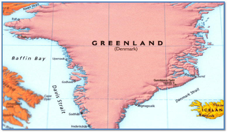
Davis Strait / डेविस स्ट्रेट
Location In News
A microcontinent has been recently discovered in the Davis Strait, between Canada and Greenland.

About the newly discovered Microcontinent:
- The discovery was made around the Davis Strait, a large stretch of water located between Canada’s Baffin Island and Greenland.
- The strait was formed millions of years ago when the tectonic plates between the two islands shifted, reconfiguring the Earth’s crust.
- This resulted in the formation of a thick continental crust in the ocean, which has now been declared a newly discovered primitive microcontinent.
- It has been named the Davis Strait proto-microcontinent since it formed owing to the tectonic evolution of the strait in the region.
- The microcontinent is 19–24 km thick thinned continental crust and is surrounded by two narrow bands of thin (15–17 km) continental crust.
Key Facts about Davis Strait:
- Also known as the northern arm of the Atlantic Ocean, the Davis Strait is situated north of the Labrador Sea amidst southwestern Greenland and southeastern Baffin Island in Nunavut, Canada.
- It separates the depths of northern Baffin Bay from the southern Labrador Sea and forms an important part of the Northwest passage route going through the Canadian Arctic Archipelago and connecting the Atlantic and Pacific Oceans.
- Baffin Bay is situated between Baffin Island and Greenland’s west coast.
- Defined as a marginal sea of the Arctic Ocean, it is also considered a small sea of the North Atlantic.
- It is not navigable during the winter months due to the thick ice cover, floating icebergs and heavy fog.
- The Davis Strait is approximately 400 miles (650 km) north to south and 200 to 400 miles wide.
- It has a water depth ranging from 1000 to 2000 metres, and is comparatively shallower than the southern Labrador Sea.
- The Davis Strait is home to complex geological formations such as underwater basins and ridges that were created due to the strike-slip faulting along the Ungava fault Zone around 45 to 62 million years ago.
- It triggered plate tectonic movements in the Labrador Sea and the Baffin Bay, leading to the formation of the Strait.
- Two different ocean currents are active in the Davis Strait, with contrasting temperatures leading to varying concentrations of ice on the eastern and western sides of the Strait.
- From the shores of Greenland, the western Greenland current carries comparatively warmer waters towards the east, while the Labrador current pushes iceberg-filled water southward along the Canadian coast, the Labrador Sea, and subsequently the Atlantic.
- Ice conditions reflect this flow regime, with heavy ice movement and icebergs along the western shore contrasting sharply with more open water along the Greenland side.
डेविस स्ट्रेट
हाल ही में कनाडा और ग्रीनलैंड के बीच डेविस जलडमरूमध्य में एक सूक्ष्म महाद्वीप की खोज की गई है।
नए खोजे गए माइक्रोकॉन्टिनेंट के बारे में:
- यह खोज डेविस स्ट्रेट के आसपास की गई थी, जो कनाडा के बाफिन द्वीप और ग्रीनलैंड के बीच स्थित पानी का एक बड़ा हिस्सा है।
- यह स्ट्रेट लाखों साल पहले बना था जब दो द्वीपों के बीच टेक्टोनिक प्लेट्स खिसक गईं, जिससे पृथ्वी की पपड़ी फिर से बन गई।
- इसके परिणामस्वरूप समुद्र में एक मोटी महाद्वीपीय परत का निर्माण हुआ, जिसे अब एक नए खोजे गए आदिम माइक्रोकॉन्टिनेंट के रूप में घोषित किया गया है।
- इसे डेविस स्ट्रेट प्रोटो-माइक्रोकॉन्टिनेंट नाम दिया गया है क्योंकि यह क्षेत्र में स्ट्रेट के टेक्टोनिक विकास के कारण बना है।
- यह माइक्रोकॉन्टिनेंट 19-24 किमी मोटी पतली महाद्वीपीय परत है और पतली (15-17 किमी) महाद्वीपीय परत की दो संकीर्ण पट्टियों से घिरा हुआ है।
डेविस स्ट्रेट के बारे में मुख्य तथ्य:
- अटलांटिक महासागर की उत्तरी भुजा के रूप में भी जाना जाता है, डेविस स्ट्रेट कनाडा के नुनावुत में दक्षिण-पश्चिमी ग्रीनलैंड और दक्षिण-पूर्वी बाफिन द्वीप के बीच लैब्राडोर सागर के उत्तर में स्थित है।
- यह उत्तरी बाफिन खाड़ी की गहराई को दक्षिणी लैब्राडोर सागर से अलग करता है और कनाडाई आर्कटिक द्वीपसमूह से होकर गुजरने वाले और अटलांटिक और प्रशांत महासागरों को जोड़ने वाले उत्तर-पश्चिमी मार्ग का एक महत्वपूर्ण हिस्सा बनाता है।
- बाफिन खाड़ी बाफिन द्वीप और ग्रीनलैंड के पश्चिमी तट के बीच स्थित है।
- आर्कटिक महासागर के सीमांत समुद्र के रूप में परिभाषित, इसे उत्तरी अटलांटिक का एक छोटा समुद्र भी माना जाता है।
- मोटी बर्फ की चादर, तैरते हिमखंड और घने कोहरे के कारण यह सर्दियों के महीनों के दौरान नौगम्य नहीं है।
- डेविस जलडमरूमध्य उत्तर से दक्षिण तक लगभग 400 मील (650 किमी) और 200 से 400 मील चौड़ा है।
- इसकी पानी की गहराई 1000 से 2000 मीटर तक है, और यह दक्षिणी लैब्राडोर सागर की तुलना में अपेक्षाकृत उथला है।
- डेविस जलडमरूमध्य जटिल भूवैज्ञानिक संरचनाओं जैसे पानी के नीचे के बेसिन और कटक का घर है जो लगभग 45 से 62 मिलियन साल पहले अनगावा फॉल्ट ज़ोन के साथ स्ट्राइक-स्लिप फॉल्टिंग के कारण बने थे।
- इसने लैब्राडोर सागर और बाफिन खाड़ी में प्लेट टेक्टोनिक आंदोलनों को ट्रिगर किया, जिससे जलडमरूमध्य का निर्माण हुआ।
- डेविस जलडमरूमध्य में दो अलग-अलग महासागरीय धाराएं सक्रिय हैं, जिनमें विपरीत तापमान के कारण जलडमरूमध्य के पूर्वी और पश्चिमी किनारों पर बर्फ की अलग-अलग सांद्रता होती है।
- ग्रीनलैंड के तटों से, पश्चिमी ग्रीनलैंड की धारा तुलनात्मक रूप से गर्म पानी को पूर्व की ओर ले जाती है, जबकि लैब्राडोर की धारा हिमखंड से भरे पानी को कनाडा के तट, लैब्राडोर सागर और बाद में अटलांटिक के साथ दक्षिण की ओर धकेलती है।
- बर्फ की स्थिति इस प्रवाह व्यवस्था को दर्शाती है
The issue with tree planting schemes / पेड़ लगाने की योजनाओं से जुड़ी समस्या
Editorial Analysis: Syllabus : GS: 3 : Environment – Environmental pollution and degradation
Source : The Hindu
Context
- The uncontrolled exploitation of forest resources has led to significant degradation of forest landscapes worldwide.
- In response, the United Nations declared 2021-2030 as the Decade of Ecosystem Restoration, aiming to restore 350 million hectares of degraded land and enhance global efforts in forest conservation and biodiversity through initiatives like mass tree planting.
Introduction
- Degraded Forest Landscapes: The exploitation of forest resources due to uncontrolled and unsustainable practices has degraded forest landscapes.
- World Bank Estimates: The World Bank estimates that the world has lost about 10 million square kilometers of forests since the start of the 20th century.
- Ecosystem Restoration: The emphasis on forest restoration approaches led to the United Nations declaring 2021-2030 as the Decade of Ecosystem Restoration.
- Initiative Targets: This initiative targets the restoration of 350 million hectares of degraded land to generate $9 trillion in ecosystem services and sequester an additional 13 gigatons to 26 gigatons of greenhouse gases from the atmosphere.
Recent Trends of Special Conservation Drives:
- Increased Initiatives: There has been a surge in global and national tree planting drives, such as the “One Trillion Project” by the World Economic Forum, Pakistan’s “10 Billion Tree Tsunami,” China’s “Great Green Wall,” and the “Bonn Challenge” to restore degraded landscapes.
- High Media Attention: These drives often feature catchy slogans and glamorous campaigns that attract substantial media attention and public involvement.
- Annual Events: India celebrates Van Mahotsava annually in July, aiming to promote tree planting and environmental conservation.
Importance of Tree Planting
- Proven Method: Tree planting is a proven method to support and sustain biodiversity and address climate-related crises and environmental challenges.
- Carbon Sequestration: It includes biological carbon sequestration, a mechanism to store and remove carbon dioxide from the atmosphere.
- Tackle Climate Change: Mass-scale tree planting is seen as a potential solution to tackle climate change globally, endorsed by both governmental and non-governmental organisations.
- Ecological Balance: Recognizing the role of trees in maintaining ecological balance, India launched the Van Mahotsava (‘festival of trees’) program in July 1950.
- Planting Program: India has celebrated this tree planting program annually in the first week of July, which has successfully motivated people and improved forest areas.
Issues Associated with These Drives:
- Limited Community Participation: Many programs lack significant involvement from local communities, affecting their effectiveness and sustainability.
- Post-Planting Measures: Insufficient focus on post-planting care and monitoring hinders the success of tree planting efforts.
- Monoculture Risks: Some drives promote monoculture, which can be detrimental to biodiversity and carbon sequestration.
- Ecological Impact: Inappropriate tree planting in non-deforested areas like grasslands or animal habitats can damage ecosystems, increase wildfire risk, and exacerbate global warming.
Post-Planting Measures and Alternative Approaches
- Measures and Monitoring: Planting saplings alone does not meet expectations without adequate post-planting measures and monitoring of tree growth.
- Government Support: Many tree-planting drives, especially those not supported by the government, lack these provisions.
- Cost-Effective Climate Solution: Contrary to popular belief, tree planting is not always a cost-effective climate solution compared to other approaches such as restoration and tree islands, which involve planting in small patches or islands.
India’s Accountability and Challenges Toward Environmental Goals:
- Achievements: India claims to have fulfilled its Paris Agreement commitments and achieved an additional carbon sink of 1.97 billion tonnes of CO2 equivalent.
- Encroachment and Loss: Approximately 10 million hectares of Indian forests are under encroachment, and about 5.7 million hectares have been lost for non-forestry purposes.
- Dependence on Forests: Nearly 27.5 crore people rely on forests for subsistence, highlighting the importance of sustainable management.
- Restoration Goals: India aims to restore 26 million hectares of degraded forests by 2030, but faces challenges such as encroachment and the need for effective tree planting strategies.
Way forward:
- Community Involvement: Need to foster local participation in tree planting drives by involving communities in planning, execution, and ongoing maintenance.
- Monitoring and Maintenance: Try to implement robust post-planting monitoring and care systems to ensure the survival and growth of planted trees.
- Policy and Strategy Improvements: To address criticism of mass planting drives, India needs to prioritize adequate financing, active community participation, and technical considerations in forestry and restoration strategies.
History of Van Mahotsav
- Van Mahotsav or ‘Forest festival’ is an annual one-week tree-planting festival in India.
- The history of Van Mahotsav Day goes back to July 1947.
- It was first organized by the Punjabi botanist, M.S. Randhawa.
- According to the IUCN, deforestation and forest degradation contribute around 12% of global greenhouse gas emissions and the total area occupied by primary forests in India has decreased by 3.6%.
Forest landscape restoration
- Typically, governments have relied on afforestation and reforestation as a means of establishing trees on non-treed land.
- These strategies have now evolved, and the focus now is on forest landscape restoration.
- Landscape restoration is the process of regaining ecological functionality and improving human welfare across deforested or degraded forest landscapes.
- Forest landscape restoration seeks to involve communities in the process of designing and executing mutually advantageous interventions for the upgradation of landscapes.
- Nearly 2 billion hectares of degraded land in the world (and 140 million hectares in India) have scope for potential restoration as forestland.
- A crucial aspect of the landscape restoration process is to ensure the diversity of the species while planting trees.
- Natural forests with diverse native tree species are more efficient in sequestering carbon than monoculture tree plantations.
- Planting diverse species is also healthier for local communities and their livelihoods, and has positive impact on the quality of the forests.
Importance of forest landscape restoration
- Forests are integral in regulating ecosystems, influencing the carbon cycle and mitigating the effects of climate change.
- Annually, forests absorb roughly 2.6 billion tonnes of carbon dioxide (CO2). This absorption includes nearly 33% of the CO2 released from burning of fossil fuels.
- Forests are a boon for local communities and their livelihoods by functioning as a resource base for goods and services.
- According to the World Resources Institute, forest ecosystems enrich soil fertility and water availability, enhancing agricultural productivity, and in turn the rural economy.
- Tree planting prevents erosion and stems flooding.
- Sustainable forest crops reduce food insecurity and empower women, allowing them to gain access to more nutritional diets and new income streams.
- Agroforestry lessens rural-to-urban migration and contributes to an increase in resources and household income.
- Planting trees is deeply linked to the ‘holistic’ well-being of all individuals, the community, and the planet.
Programmes carried out in India
- The span 2021-2030 is the UN Decade on Ecosystem Restoration, emphasizing efforts to restore degraded terrestrial ecosystems including forests.
- In 2011, the Bonn Challenge was launched with a global goal to restore 150 million hectares of degraded and deforested landscapes by 2020 and 350 million hectares by 2030.
- India joined the Bonn Challenge in 2015, pledging to restore 26 million hectares of degraded and deforested land by 2030.
- An additional carbon sink of 2.5 billion-3 billion tonnes of CO2 equivalent through forest and tree cover is to be created by 2030.
- Other Indian government programmes are,
- The Compensatory Afforestation,
- The National Afforestation Programme,
- The National Mission for Green India (Green India Mission),
- The Nagar Van scheme and
- The Forest Fire Prevention and Management Scheme, etc.
- There is a spotlight on youth via the Green Skill Development Programme for youth who aspire to attain employment in the environment and forest sectors.
- State governments are not far behind either, a case in point being Telangana, which has initiated a large-scale tree planting programme called Telanganaku Haritha Haram.
Hurdles in India
- Forest restoration in India faces hurdles in terms of the identification of areas for restoration, and financing.
- There is a lack of importance accorded to research and scientific strategies in tree planting, stakeholders’ conflicts of interest, etc.
Way forward
- To be successful, forest landscape restoration must be implemented proactively.
- Strengthening landscapes and forest ecosystems to be durable and adjustable in the face of future challenges and societal needs is a must.
- The restoration of natural forest ecosystems can be strengthened through participatory governance by engaging stakeholders, as in the Punjab example.
- Vulnerable forest-dependent communities should be factored in, and any effort should be tailored to the local socio-economic context and landscape history of a region.
पेड़ लगाने की योजनाओं से जुड़ी समस्या
Context
- वन संसाधनों के अनियंत्रित दोहन के कारण दुनिया भर में वन परिदृश्यों में महत्वपूर्ण गिरावट आई है।
- प्रतिक्रिया में, संयुक्त राष्ट्र ने 2021-2030 को पारिस्थितिकी तंत्र बहाली का दशक घोषित किया, जिसका उद्देश्य 350 मिलियन हेक्टेयर क्षरित भूमि को बहाल करना और बड़े पैमाने पर वृक्षारोपण जैसी पहलों के माध्यम से वन संरक्षण और जैव विविधता में वैश्विक प्रयासों को बढ़ाना है।
परिचय
- क्षयग्रस्त वन परिदृश्य: अनियंत्रित और असंवहनीय प्रथाओं के कारण वन संसाधनों के दोहन ने वन परिदृश्यों को क्षरित कर दिया है।
- विश्व बैंक का अनुमान: विश्व बैंक का अनुमान है कि 20वीं सदी की शुरुआत से दुनिया ने लगभग 10 मिलियन वर्ग किलोमीटर वन खो दिए हैं।
- पारिस्थितिकी तंत्र बहाली: वन बहाली के तरीकों पर जोर देने के कारण संयुक्त राष्ट्र ने 2021-2030 को पारिस्थितिकी तंत्र बहाली का दशक घोषित किया।
- पहल के लक्ष्य: इस पहल का लक्ष्य 350 मिलियन हेक्टेयर बंजर भूमि को बहाल करना है, ताकि पारिस्थितिकी तंत्र सेवाओं में $9 ट्रिलियन का उत्पादन किया जा सके और वायुमंडल से अतिरिक्त 13 गीगाटन से 26 गीगाटन ग्रीनहाउस गैसों को अलग किया जा सके।
विशेष संरक्षण अभियानों के हालिया रुझान:
- बढ़ी हुई पहल: वैश्विक और राष्ट्रीय वृक्षारोपण अभियानों में उछाल आया है, जैसे कि विश्व आर्थिक मंच द्वारा “वन ट्रिलियन प्रोजेक्ट”, पाकिस्तान की “10 बिलियन ट्री सुनामी”, चीन की “ग्रेट ग्रीन वॉल” और बंजर भूमि को बहाल करने के लिए “बॉन चैलेंज”।
- मीडिया का उच्च ध्यान: इन अभियानों में अक्सर आकर्षक नारे और आकर्षक अभियान होते हैं, जो पर्याप्त मीडिया ध्यान और सार्वजनिक भागीदारी को आकर्षित करते हैं।
- वार्षिक कार्यक्रम: भारत हर साल जुलाई में वन महोत्सव मनाता है, जिसका उद्देश्य वृक्षारोपण और पर्यावरण संरक्षण को बढ़ावा देना है।
वृक्षारोपण का महत्व
- सिद्ध विधि: वृक्षारोपण जैव विविधता का समर्थन और उसे बनाए रखने तथा जलवायु संबंधी संकटों और पर्यावरणीय चुनौतियों का समाधान करने का एक सिद्ध तरीका है।
- कार्बन पृथक्करण: इसमें जैविक कार्बन पृथक्करण शामिल है, जो वायुमंडल से कार्बन डाइऑक्साइड को संग्रहीत करने और निकालने का एक तंत्र है।
- जलवायु परिवर्तन से निपटना: बड़े पैमाने पर वृक्षारोपण को वैश्विक स्तर पर जलवायु परिवर्तन से निपटने के लिए एक संभावित समाधान के रूप में देखा जाता है, जिसका समर्थन सरकारी और गैर-सरकारी दोनों संगठनों द्वारा किया जाता है।
- पारिस्थितिक संतुलन: पारिस्थितिक संतुलन बनाए रखने में पेड़ों की भूमिका को पहचानते हुए, भारत ने जुलाई 1950 में वन महोत्सव (‘पेड़ों का त्योहार’) कार्यक्रम शुरू किया।
- पौधा रोपण कार्यक्रम: भारत ने जुलाई के पहले सप्ताह में हर साल इस वृक्षारोपण कार्यक्रम को मनाया है, जिसने लोगों को सफलतापूर्वक प्रेरित किया है और वन क्षेत्रों में सुधार किया है।
इन अभियानों से जुड़े मुद्दे:
- सीमित सामुदायिक भागीदारी: कई कार्यक्रमों में स्थानीय समुदायों की महत्वपूर्ण भागीदारी का अभाव है, जो उनकी प्रभावशीलता और स्थिरता को प्रभावित करता है।
- पौधा रोपण के बाद के उपाय: रोपण के बाद देखभाल और निगरानी पर अपर्याप्त ध्यान वृक्षारोपण प्रयासों की सफलता में बाधा डालता है।
- मोनोकल्चर जोखिम: कुछ अभियान मोनोकल्चर को बढ़ावा देते हैं, जो जैव विविधता और कार्बन पृथक्करण के लिए हानिकारक हो सकता है।
- पारिस्थितिक प्रभाव: घास के मैदानों या जानवरों के आवास जैसे गैर-वन क्षेत्रों में अनुचित वृक्षारोपण पारिस्थितिकी तंत्र को नुकसान पहुंचा सकता है, जंगल में आग लगने का जोखिम बढ़ा सकता है और ग्लोबल वार्मिंग को बढ़ा सकता है।
पौधे लगाने के बाद के उपाय और वैकल्पिक दृष्टिकोण
- उपाय और निगरानी: पर्याप्त पौधरोपण के बाद के उपायों और वृक्ष वृद्धि की निगरानी के बिना अकेले पौधे लगाना अपेक्षाओं को पूरा नहीं करता है।
- सरकारी सहायता: कई वृक्षारोपण अभियान, विशेष रूप से वे जो सरकार द्वारा समर्थित नहीं हैं, इन प्रावधानों का अभाव रखते हैं।
- लागत-प्रभावी जलवायु समाधान: आम धारणा के विपरीत, वृक्षारोपण हमेशा अन्य तरीकों जैसे कि बहाली और वृक्ष द्वीपों की तुलना में लागत-प्रभावी जलवायु समाधान नहीं होता है, जिसमें छोटे-छोटे पैच या द्वीपों में पौधे लगाना शामिल होता है।
पर्यावरण लक्ष्यों के प्रति भारत की जवाबदेही और चुनौतियाँ:
- उपलब्धियाँ: भारत का दावा है कि उसने पेरिस समझौते की अपनी प्रतिबद्धताओं को पूरा किया है और 97 बिलियन टन CO2 समतुल्य अतिरिक्त कार्बन सिंक हासिल किया है।
- अतिक्रमण और नुकसान: लगभग 10 मिलियन हेक्टेयर भारतीय वन अतिक्रमण के अधीन हैं, और लगभग 7 मिलियन हेक्टेयर गैर-वानिकी उद्देश्यों के लिए नष्ट हो गए हैं।
- वनों पर निर्भरता: लगभग 5 करोड़ लोग निर्वाह के लिए वनों पर निर्भर हैं, जो स्थायी प्रबंधन के महत्व को दर्शाता है।
- पुनर्स्थापना लक्ष्य: भारत का लक्ष्य 2030 तक 26 मिलियन हेक्टेयर क्षरित वनों को बहाल करना है, लेकिन अतिक्रमण और प्रभावी वृक्षारोपण रणनीतियों की आवश्यकता जैसी चुनौतियों का सामना करना पड़ रहा है।
आगे की राह:
- समुदाय की भागीदारी: नियोजन, निष्पादन और चल रहे रखरखाव में समुदायों को शामिल करके वृक्षारोपण अभियानों में स्थानीय भागीदारी को बढ़ावा देने की आवश्यकता है।
- निगरानी और रखरखाव: लगाए गए पेड़ों के अस्तित्व और विकास को सुनिश्चित करने के लिए मजबूत पोस्ट-प्लांटिंग निगरानी और देखभाल प्रणालियों को लागू करने का प्रयास करें।
- नीति और रणनीति सुधार: बड़े पैमाने पर वृक्षारोपण अभियान की आलोचना को संबोधित करने के लिए, भारत को वानिकी और बहाली रणनीतियों में पर्याप्त वित्तपोषण, सक्रिय सामुदायिक भागीदारी और तकनीकी विचारों को प्राथमिकता देने की आवश्यकता है।
वन महोत्सव का इतिहास
- वन महोत्सव या ‘वन महोत्सव’ भारत में एक वार्षिक एक सप्ताह का वृक्षारोपण उत्सव है।
- वन महोत्सव दिवस का इतिहास जुलाई 1947 से शुरू होता है।
- इसे पहली बार पंजाबी वनस्पतिशास्त्री एम.एस. रंधावा ने आयोजित किया था।
- आईयूसीएन के अनुसार, वनों की कटाई और वन क्षरण वैश्विक ग्रीनहाउस गैस उत्सर्जन में लगभग 12% योगदान देता है और भारत में प्राथमिक वनों द्वारा कब्जा किए गए कुल क्षेत्र में 6% की कमी आई है।
वन परिदृश्य बहाली
- आमतौर पर, सरकारें गैर-पेड़ वाली भूमि पर पेड़ लगाने के साधन के रूप में वनीकरण और पुनर्वनीकरण पर निर्भर रही हैं।
- ये रणनीतियाँ अब विकसित हो चुकी हैं, और अब ध्यान वन परिदृश्य बहाली पर है।
- परिदृश्य बहाली, वनों की कटाई या क्षीण हो चुके वन परिदृश्यों में पारिस्थितिक कार्यक्षमता को पुनः प्राप्त करने और मानव कल्याण में सुधार करने की प्रक्रिया है।
- वन परिदृश्य बहाली का उद्देश्य परिदृश्यों के उन्नयन के लिए पारस्परिक रूप से लाभप्रद हस्तक्षेपों को डिजाइन करने और निष्पादित करने की प्रक्रिया में समुदायों को शामिल करना है।
- दुनिया में लगभग 2 बिलियन हेक्टेयर क्षरित भूमि (और भारत में 140 मिलियन हेक्टेयर) में वन भूमि के रूप में संभावित बहाली की गुंजाइश है।
- परिदृश्य बहाली प्रक्रिया का एक महत्वपूर्ण पहलू पेड़ लगाते समय प्रजातियों की विविधता सुनिश्चित करना है।
- विविध देशी वृक्ष प्रजातियों वाले प्राकृतिक वन मोनोकल्चर वृक्षारोपण की तुलना में कार्बन को अलग करने में अधिक कुशल हैं।
- विविध प्रजातियों का रोपण स्थानीय समुदायों और उनकी आजीविका के लिए भी स्वस्थ है, और इसका वनों की गुणवत्ता पर सकारात्मक प्रभाव पड़ता है।
वन परिदृश्य बहाली का महत्व
- वन पारिस्थितिकी तंत्र को विनियमित करने, कार्बन चक्र को प्रभावित करने और जलवायु परिवर्तन के प्रभावों को कम करने में अभिन्न अंग हैं।
- वन सालाना लगभग 6 बिलियन टन कार्बन डाइऑक्साइड (CO2) अवशोषित करते हैं। इस अवशोषण में जीवाश्म ईंधन के जलने से निकलने वाली CO2 का लगभग 33% शामिल है।
- वन स्थानीय समुदायों और उनकी आजीविका के लिए वस्तुओं और सेवाओं के लिए संसाधन आधार के रूप में कार्य करके एक वरदान हैं।
- विश्व संसाधन संस्थान के अनुसार, वन पारिस्थितिकी तंत्र मिट्टी की उर्वरता और जल उपलब्धता को समृद्ध करते हैं, कृषि उत्पादकता को बढ़ाते हैं और बदले में ग्रामीण अर्थव्यवस्था को बढ़ावा देते हैं।
वृक्षारोपण कटाव और बाढ़ को रोकता है।
- संधारणीय वन फसलें खाद्य असुरक्षा को कम करती हैं और महिलाओं को सशक्त बनाती हैं, जिससे उन्हें अधिक पौष्टिक आहार और आय के नए स्रोत प्राप्त करने में मदद मिलती है।
- कृषि वानिकी ग्रामीण से शहरी प्रवास को कम करती है और संसाधनों और घरेलू आय में वृद्धि में योगदान देती है।
- वृक्षारोपण सभी व्यक्तियों, समुदाय और ग्रह की ‘समग्र’ भलाई से गहराई से जुड़ा हुआ है।
भारत में किए गए कार्यक्रम
- 2021-2030 की अवधि पारिस्थितिकी तंत्र बहाली पर संयुक्त राष्ट्र दशक है, जिसमें वनों सहित क्षीण स्थलीय पारिस्थितिकी तंत्र को बहाल करने के प्रयासों पर जोर दिया गया है।
- 2011 में, बॉन चैलेंज की शुरुआत वैश्विक लक्ष्य के साथ की गई थी, जिसका लक्ष्य 2020 तक 150 मिलियन हेक्टेयर क्षरित और वनों से रहित भूमि को बहाल करना तथा 2030 तक 350 मिलियन हेक्टेयर भूमि को बहाल करना था।
- भारत 2015 में बॉन चैलेंज में शामिल हुआ, जिसने 2030 तक 26 मिलियन हेक्टेयर क्षरित और वनों से रहित भूमि को बहाल करने का संकल्प लिया।
- 2030 तक वन और वृक्ष आवरण के माध्यम से 5 बिलियन-3 बिलियन टन CO2 समतुल्य अतिरिक्त कार्बन सिंक बनाया जाना है।
- भारत सरकार के अन्य कार्यक्रम हैं,
- प्रतिपूरक वनरोपण,
- राष्ट्रीय वनरोपण कार्यक्रम,
- राष्ट्रीय हरित भारत मिशन (हरित भारत मिशन),
- नगर वन योजना और
- वन अग्नि निवारण एवं प्रबंधन योजना, आदि।
- पर्यावरण और वन क्षेत्रों में रोजगार पाने की इच्छा रखने वाले युवाओं के लिए हरित कौशल विकास कार्यक्रम के माध्यम से युवाओं पर ध्यान केंद्रित किया जा रहा है।
- राज्य सरकारें भी पीछे नहीं हैं, इसका एक उदाहरण तेलंगाना है, जिसने तेलंगानाकु हरिता हरम नामक एक बड़े पैमाने पर वृक्षारोपण कार्यक्रम शुरू किया है।
भारत में बाधाएँ
- भारत में वन बहाली में बहाली के लिए क्षेत्रों की पहचान और वित्तपोषण के मामले में बाधाओं का सामना करना पड़ता है।
- वृक्षारोपण, हितधारकों के हितों के टकराव आदि में अनुसंधान और वैज्ञानिक रणनीतियों को महत्व नहीं दिया जाता है।
आगे की राह
- सफल होने के लिए, वन परिदृश्य बहाली को सक्रिय रूप से लागू किया जाना चाहिए।
- भविष्य की चुनौतियों और सामाजिक आवश्यकताओं के सामने टिकाऊ और समायोज्य होने के लिए परिदृश्य और वन पारिस्थितिकी तंत्र को मजबूत करना आवश्यक है।
- पंजाब के उदाहरण की तरह, हितधारकों को शामिल करके भागीदारीपूर्ण शासन के माध्यम से प्राकृतिक वन पारिस्थितिकी तंत्र की बहाली को मजबूत किया जा सकता है।
- वनों पर निर्भर कमजोर समुदायों को भी ध्यान में रखा जाना चाहिए, और किसी भी प्रयास को स्थानीय सामाजिक-आर्थिक संदर्भ और क्षेत्र के परिदृश्य इतिहास के अनुरूप बनाया जाना चाहिए।
The Peninsular River System [Mapping] / प्रायद्वीपीय नदी प्रणाली [मानचित्रण]

Peninsular River – Evolution
- Three important geological occurrences in the distant past shaped Peninsular India’s current drainage networks.
- During the early tertiary era, the western flank of the Peninsula began to sink, resulting in its submergence beneath the sea.
- In general, it has disrupted the river’s symmetrical layout on both sides of the original watershed.
- The Himalayas were upheaved when the peninsular block’s northern flank was subjected to subsidence and trough faulting.
- The Narmada and Tapi rivers run across faults, filling the original fractures with sediment.
- As a result, alluvial and deltaic deposits are scarce in these rivers.
- During the same era, a little tilt of the peninsular block from northwest to south-eastern imparted orientation to the whole drainage system towards the Bay of Bengal.
Smaller Rivers of India flowing towards West
- The rivers that feed into the Arabian Sea have very short courses.
- These west-flowing rivers will eventually reach the Arabian Sea.
Sabarmati River
- One of India’s most major west-flowing rivers is the Sabarmati.
- It starts in the Aravalli Range in Rajasthan’s Udaipur District and finishes at the Arabian Sea’s Gulf of Khambhat after travelling 371 kilometres through Rajasthan and Gujarat.
- The Aravalli hills border the basin on the north and north-east, the Rann of Kutch on the west, and the Gulf of Khambhat on the south.
- The Watrak, Wakal, Hathmati, Harnav, and Sei rivers are the major tributaries.
Mahi River
- Western India is home to the Mahi River.
- It starts in Madhya Pradesh and flows through Rajasthan’s Vagad region before entering Gujarat and emptying into the Arabian Sea.
- The Aravalli hills surround it on the north and north-west, the Malwa Plateau on the east, the Vindhyas on the south, and the Gulf of Khambhat on the west.
- Mahi is a major interstate west-flowing river in India.
- Som is a right bank tributary of Mahi river.
- Anas and Panam rivers are the tributaries of Mahi on the left bank.
Dhandhar River
- Its origins may be traced back to Jamnagar’s Lalpur district.
- The main fluvial sedimentary facies of the Late Pleistocene deposits in the Dhadhar River basin have preserved palaeo-drainage signals and may serve as an important link between the sub-humid Narmada basin in the south and the semi-arid Mahi basin in the north.
- Vishwamitri, Jambuo, Dev, and Surya rivers are significant tributaries of the Dhadhar river.
Sharavati River
- The Sharavati River flows through the Indian state of Karnataka.
- It begins in the Western Ghats and goes northwest for 60 miles (100 kilometres) to Honavar on the Arabian Sea.
- Ambuthirtha is a mountain in Shimoga District, Karnataka, India, near the village of Thirthahalli. It is the source of the Sharavathi River.
- The river basin of the Sharavati is extensively wooded.
- Nandihole, Haridravathi, Mavinahole, Hilkunji, Yennehole, Hurlihole, and Nagodihole are the river’s principal tributaries.
Bharathapuzha River
- The Bharathapuzha River, which flows into the Arabian Sea, is Kerala’s second longest West Flowing River.
- It is bounded on the east by the Cauvery basin and on the west by the Arabian Sea.
- Bharathapuzha is a river in Kerala, India. It is also known as the Nila, Ponnani, or Kuttippuram River.
- The main course of the Bharathapuzha begins as a series of minor rivulets in the Western Ghats near the Anamalai hill ranges in Tamil Nadu.
- The three major tributaries are the Gayathripuzha, Kalpathipuzha, and Pulanthode.
Periyar River
- The source of the Periyar lies high in the Western Ghats. The Periyar River begins on the southeastern edge of the Idukki district.
- The river’s headwaters are in the isolated woods of the Periyar Tiger Reserve.
- According to various reports, the river’s source is Chokkampatti Mala, a hill on the southern fringe of the Periyar Tiger Reserve.
- The Periyar River originates in the Sivagiri Hills of the Western Ghats and flows through the Periyar National Park.
- It ultimately drains into Vembanad Lake, which finally empties into the Arabian Sea.
- The Periyar River is the longest and has the highest discharge capacity in the Indian state of Kerala.
- Muthirapuzha River, Mullayar River, Cheruthoni River, Perinjankutti River, and Edamala River are its primary tributaries.
- Muthayar, Perunthuraiar, Chinnar, Cheruthony, and Kattappanayar are minor tributaries.
Small Rivers Flowing towards the East
- A huge number of rivers, as well as their tributaries, flow to the east.
- There are several tiny rivers that connect to the Bay of Bengal, and while they are little, they are significant in their own way.
Subarnarekha River
- It begins at an elevation of 600 metres in Nagri hamlet in Jharkhand’s Ranchi area.
- It is bounded on the north-west by the Chota Nagpur Plateau, on the south-west by the Brahmani basin, on the south by the Burhabalang basin, and on the south-east by the Bay of Bengal.
- Hundru Falls, which falls from a height of 98 metres, is produced along the Subarnarekha River.
- The numerous rock formations developed as a consequence of erosion by the constantly running water have contributed to the area’s allure.
- The Subarnarekha’s major tributaries are the Kharkai, Roro, Kanchi, Harmu Nadi, Damra, Karru, Chinguru, Karakari, Gurma, Garra, Singaduba, Kodia, Dulunga, and Khaijori.
Baitarani River
- The Baitarani is a large east-flowing river in peninsular India that finally flows into the Bay of Bengal.
- The Baitarani flows through the Gonasika hills and through a stone shaped like a cow’s nose.
- The Baitarani is known as Guptaganga or Gupta Baitarani in the Indian state of Odisha.
- Baitarani’s commencement is a short stretch of the boundary between the states of Odisha and Jharkhand.
- Baitarani’s tributaries are the Budhi, Kanjori, Ambajhara, Mushal, Kusei, and Salandi.
Brahmani River
- The Brahmani river originates in Nagri village in Jharkhand’s Ranchi area at a height of around 600 metres and travels for 799 kilometres.
- The Brahmani River flows south through the valleys created by the Garhjat Hills to reach the well-known Gangpur Basin. In this location, the Brahmani River is joined by a number of fast-flowing tributaries.
- The deltaic zone of Brahmani begins 315.00 kilometres downstream from Jenapur, when the Kalamitra island divides the river into two streams.
- Brahmani tributaries include Koel, Kuradhi, Mankara, Samakoi, Ramiala, Karo, Sankh, Rukura, Gohira, Tikira, Singdajhor, Nigra, Barjor, and Nandira.
Pennar River
- The Pennar River, also known as the Uttara Pinakini in India, is a river.
- The Pennar River is a vital waterway in Peninsular India.
- Pennar River begins in Karnataka’s Nandi highlands’ Chenna Kesava hills and flows for around 597 kilometres before draining into the Bay of Bengal.
- The Pennar and its tributaries watershed span a section of the southern Deccan plateau, including the bulk of Andhra Pradesh’s Rayalaseema region and a piece of Karnataka.
- The Kolar Plateau divides the Pennar watershed from the Kaveri, Ponnaiyar, and Palar river basins to the south.
- The river’s major tributaries are the Jayamangal, Kunder, Sagileru, Chitravati, Papagni, and Cheyyeru.
Palar River
- It starts in Karnataka’s Chikkaballapur district and goes through Karnataka, Andhra Pradesh, and Tamil Nadu until entering the Bay of Bengal at Vayalur, south of Chennai.
- The flow of the Palar is unpredictable, with large variations from year to year.
- The Palar Basin is one of the most significant of the 12 basins that connect the Pennar and Cauvery basins.
- The river Palar is fed by two major tributaries: the Ponni on the left bank and the Cheyyar on the right.
प्रायद्वीपीय नदी प्रणाली [मानचित्रण]
प्रायद्वीपीय नदी – विकास
- सुदूर अतीत में तीन महत्वपूर्ण भूगर्भीय घटनाओं ने प्रायद्वीपीय भारत के वर्तमान जल निकासी नेटवर्क को आकार दिया।
- प्रारंभिक तृतीयक युग के दौरान, प्रायद्वीप का पश्चिमी किनारा डूबने लगा, जिसके परिणामस्वरूप यह समुद्र के नीचे डूब गया।
- सामान्य तौर पर, इसने मूल जलग्रहण क्षेत्र के दोनों ओर नदी के सममित लेआउट को बाधित किया है।
- जब प्रायद्वीपीय खंड का उत्तरी किनारा अवतलन और गर्त दोष के अधीन था, तब हिमालय में उथल-पुथल हुई।
- नर्मदा और तापी नदियाँ दोषों के पार बहती हैं, जो मूल दरारों को तलछट से भर देती हैं।
- परिणामस्वरूप, इन नदियों में जलोढ़ और डेल्टाई जमा दुर्लभ हैं।
- उसी युग के दौरान, उत्तर-पश्चिम से दक्षिण-पूर्व की ओर प्रायद्वीपीय खंड का थोड़ा झुकाव पूरे जल निकासी तंत्र को बंगाल की खाड़ी की ओर उन्मुख करता है।
पश्चिम की ओर बहने वाली भारत की छोटी नदियाँ
- अरब सागर में मिलने वाली नदियों का मार्ग बहुत छोटा होता है।
- पश्चिम की ओर बहने वाली ये नदियाँ अंततः अरब सागर में पहुँच जाएँगी।
साबरमती नदी
- भारत की सबसे बड़ी पश्चिम की ओर बहने वाली नदियों में से एक साबरमती है।
- यह राजस्थान के उदयपुर जिले में अरावली पर्वतमाला से शुरू होती है और राजस्थान और गुजरात से होकर 371 किलोमीटर की यात्रा करने के बाद अरब सागर की खंभात की खाड़ी में समाप्त होती है।
- अरावली की पहाड़ियाँ उत्तर और उत्तर-पूर्व में बेसिन की सीमा बनाती हैं, पश्चिम में कच्छ का रण और दक्षिण में खंभात की खाड़ी।
- वात्रक, वाकल, हथमती, हरनव और सेई नदियाँ इसकी प्रमुख सहायक नदियाँ हैं।
माही नदी
- पश्चिमी भारत माही नदी का घर है।
- यह मध्य प्रदेश से शुरू होती है और गुजरात में प्रवेश करने और अरब सागर में मिलने से पहले राजस्थान के वागड़ क्षेत्र से होकर बहती है।
- उत्तर और उत्तर-पश्चिम में अरावली पहाड़ियाँ, पूर्व में मालवा पठार, दक्षिण में विंध्य और पश्चिम में खंभात की खाड़ी इसे घेरे हुए हैं।
- माही भारत में पश्चिम की ओर बहने वाली एक प्रमुख अंतरराज्यीय नदी है।
- सोम माही नदी की दाहिनी तटवर्ती सहायक नदी है।
- अनस और पनम नदियाँ माही की बायीं तटवर्ती सहायक नदियाँ हैं।
धंधर नदी
- इसकी उत्पत्ति जामनगर के लालपुर जिले में हुई है।
- धंधर नदी बेसिन में लेट प्लीस्टोसीन जमा की मुख्य नदी तलछटी संरचनाओं ने पुरा-जल निकासी संकेतों को संरक्षित किया है और दक्षिण में उप-आर्द्र नर्मदा बेसिन और उत्तर में अर्ध-शुष्क माही बेसिन के बीच एक महत्वपूर्ण कड़ी के रूप में काम कर सकती हैं।
- विश्वामित्री, जम्बू, देव और सूर्या नदियाँ धंधर नदी की महत्वपूर्ण सहायक नदियाँ हैं।
शरवती नदी
- शरवती नदी भारतीय राज्य कर्नाटक से होकर बहती है।
- यह पश्चिमी घाट से शुरू होकर अरब सागर पर होनावर तक 60 मील (100 किलोमीटर) उत्तर-पश्चिम में जाती है।
- अम्बुतीर्थ भारत के कर्नाटक के शिमोगा जिले में तीर्थहल्ली गाँव के पास एक पर्वत है। यह शरावती नदी का स्रोत है।
- शरावती नदी का बेसिन बड़े पैमाने पर वनाच्छादित है।
- नंदीहोल, हरिद्रावती, माविनाहोल, हिलकुंजी, येनेहोल, हुरलीहोल और नागोडिहोल नदी की प्रमुख सहायक नदियाँ हैं।
भारतपुझा नदी
- भारतपुझा नदी, जो अरब सागर में बहती है, केरल की दूसरी सबसे लंबी पश्चिम की ओर बहने वाली नदी है।
- यह पूर्व में कावेरी बेसिन और पश्चिम में अरब सागर से घिरा है।
- भारतपुझा केरल, भारत में एक नदी है। इसे नीला, पोन्नानी या कुट्टीपुरम नदी के नाम से भी जाना जाता है।
- भरतपुझा का मुख्य मार्ग तमिलनाडु में अन्नामलाई पहाड़ी श्रृंखलाओं के पास पश्चिमी घाट में छोटी-छोटी नदियों की एक श्रृंखला के रूप में शुरू होता है।
- तीन प्रमुख सहायक नदियाँ गायत्रीपुझा, कल्पतिपुझा और पुलंथोड हैं।
पेरियार नदी
- पेरियार का स्रोत पश्चिमी घाट में ऊँचा है। पेरियार नदी इडुक्की जिले के दक्षिण-पूर्वी किनारे से शुरू होती है।
- नदी का उद्गम स्थल पेरियार टाइगर रिजर्व के अलग-थलग जंगलों में है।
- विभिन्न रिपोर्टों के अनुसार, नदी का स्रोत चोक्कमपट्टी माला है, जो पेरियार टाइगर रिजर्व के दक्षिणी किनारे पर एक पहाड़ी है।
- पेरियार नदी पश्चिमी घाट की शिवगिरी पहाड़ियों से निकलती है और पेरियार राष्ट्रीय उद्यान से होकर बहती है।
- यह अंततः वेम्बनाड झील में गिरती है, जो अंततः अरब सागर में गिरती है।
- पेरियार नदी भारतीय राज्य केरल में सबसे लंबी और सबसे अधिक निर्वहन क्षमता वाली नदी है।
- मुथिरापुझा नदी, मुल्लायार नदी, चेरुथोनी नदी, पेरिंजनकुट्टी नदी और एडमाला नदी इसकी प्राथमिक सहायक नदियाँ हैं।
- मुथैयार, पेरुन्थुरैयर, चिन्नार, चेरुथोनी और कट्टप्पनयार छोटी सहायक नदियाँ हैं।
पूर्व की ओर बहने वाली छोटी नदियाँ
- बहुत सी नदियाँ और उनकी सहायक नदियाँ पूर्व की ओर बहती हैं।
- कई छोटी नदियाँ हैं जो बंगाल की खाड़ी से जुड़ती हैं, और हालाँकि वे छोटी हैं, लेकिन वे अपने तरीके से महत्वपूर्ण हैं।
सुवर्णरेखा नदी
- यह झारखंड के रांची क्षेत्र में नागरी गाँव में 600 मीटर की ऊँचाई पर शुरू होती है।
- यह उत्तर-पश्चिम में छोटा नागपुर पठार, दक्षिण-पश्चिम में ब्राह्मणी बेसिन, दक्षिण में बुरहाबलंग बेसिन और दक्षिण-पूर्व में बंगाल की खाड़ी से घिरा है।
- सुवर्णरेखा नदी के किनारे 98 मीटर की ऊँचाई से गिरने वाला हुंडरू जलप्रपात बनता है।
- लगातार बहते पानी के कटाव के परिणामस्वरूप विकसित हुई कई चट्टानी संरचनाओं ने इस क्षेत्र के आकर्षण में योगदान दिया है।
- सुवर्णरेखा की प्रमुख सहायक नदियाँ खरकई, रोरो, कांची, हरमू नदी, डमरा, करु, चिंगुरू, करकारी, गुरमा, गर्रा, सिंगडूबा, कोडिया, दुलुंगा और खैजोरी हैं।
बैतरणी नदी
- बैतरणी प्रायद्वीपीय भारत में पूर्व की ओर बहने वाली एक बड़ी नदी है जो अंततः बंगाल की खाड़ी में मिल जाती है।
- बैतरणी गोनासिका पहाड़ियों और गाय की नाक के आकार के एक पत्थर से होकर बहती है।
- बैतरणी को भारतीय राज्य ओडिशा में गुप्तगंगा या गुप्त बैतरणी के नाम से जाना जाता है।
- बैतरणी की शुरुआत ओडिशा और झारखंड राज्यों के बीच की सीमा का एक छोटा सा हिस्सा है।
- बैतरणी की सहायक नदियाँ बुधी, कंजोरी, अंबाझारा, मुशाल, कुसेई और सलांडी हैं।
ब्राह्मणी नदी
- ब्राह्मणी नदी झारखंड के रांची क्षेत्र के नागरी गांव से लगभग 600 मीटर की ऊंचाई पर निकलती है और 799 किलोमीटर तक यात्रा करती है।
- ब्राह्मणी नदी गढ़जत पहाड़ियों द्वारा बनाई गई घाटियों से होकर दक्षिण की ओर बहती है और प्रसिद्ध गंगपुर बेसिन तक पहुँचती है। इस स्थान पर, ब्राह्मणी नदी कई तेज़ बहने वाली सहायक नदियों से मिलती है।
- ब्राह्मणी का डेल्टा क्षेत्र जेनापुर से 00 किलोमीटर नीचे की ओर शुरू होता है, जब कलामित्र द्वीप नदी को दो धाराओं में विभाजित करता है।
- ब्राह्मणी की सहायक नदियों में कोयल, कुराधी, मनकारा, समाकोई, रामियाला, कारो, शंख, रुकुरा, गोहिरा, टिकिरा, सिंगदाझोर, निगरा, बरजोर और नंदीरा शामिल हैं।
पेन्नार नदी
- पेन्नार नदी, जिसे भारत में उत्तर पिनाकिनी के नाम से भी जाना जाता है, एक नदी है।
- पेन्नार नदी प्रायद्वीपीय भारत में एक महत्वपूर्ण जलमार्ग है।
- पेन्नार नदी कर्नाटक के नंदी हाइलैंड्स की चेन्ना केशव पहाड़ियों से निकलती है और बंगाल की खाड़ी में गिरने से पहले लगभग 597 किलोमीटर तक बहती है।
- पेन्नार और इसकी सहायक नदियों का जलग्रहण क्षेत्र दक्षिणी दक्कन पठार के एक हिस्से में फैला हुआ है, जिसमें आंध्र प्रदेश के रायलसीमा क्षेत्र का बड़ा हिस्सा और कर्नाटक का एक हिस्सा शामिल है।
- कोलार पठार पेन्नार जलग्रहण क्षेत्र को दक्षिण में कावेरी, पोन्नैयार और पलार नदी घाटियों से अलग करता है।
- नदी की प्रमुख सहायक नदियाँ जयमंगल, कुंदर, सागिलेरू, चित्रवती, पापाग्नि और चेयेरू हैं।
पलार नदी
- यह कर्नाटक के चिक्काबल्लापुर जिले से शुरू होती है और कर्नाटक, आंध्र प्रदेश और तमिलनाडु से होकर चेन्नई के दक्षिण में वायलूर में बंगाल की खाड़ी में प्रवेश करती है।
- पलार का प्रवाह अप्रत्याशित है, जिसमें साल-दर-साल बड़े बदलाव होते रहते हैं।
- पलार बेसिन उन 12 बेसिनों में से सबसे महत्वपूर्ण है जो पेन्नार और कावेरी बेसिन को जोड़ते हैं। पलार नदी को दो प्रमुख सहायक नदियाँ मिलती हैं: बाएं किनारे पर पोन्नी और दाएं किनारे पर चेय्यार।