CURRENT AFFAIRS – 13/09/2023
- CURRENT AFFAIRS – 13/09/2023
- IISc scientists develop novel approach to detect and kill cancer cells
- Gresham’s law: what happens when governments fix currency exchange rates?
- Nipah breaks out again in Kerala
- Eastern Libya is hit by Flash Floods
- Spotlighting another border point, the ‘rogue channel’
- Climate phenomena and Food Security
- Rajnath lays foundation stone for Nyoma airfield
CURRENT AFFAIRS – 13/09/2023
IISc scientists develop novel approach to detect and kill cancer cells
(General Studies- Paper III)

Source : TH
Indian Institute of Science (IISc) scientists have pioneered a groundbreaking approach for detecting and eradicating cancer cells, particularly those forming solid tumor masses.
- They have achieved this by creating hybrid nanoparticles composed of gold and copper sulfide, capable of both destroying cancer cells through heat and facilitating their detection via sound waves.
Key Highlights
- Hybrid Nanoparticles with Dual Functionality
- The IISc researchers amalgamated the unique properties of copper sulfide nanoparticles, known for their potential in cancer diagnosis, and gold nanoparticles, renowned for their customizable targeting of cancer cells and anticancer effects.
- The resulting hybrid nanoparticles exhibit three crucial properties: photothermal, oxidative stress, and photoacoustic.
- Photothermal Effect:
- When illuminated with light, these hybrid nanoparticles absorb the light and convert it into heat, which can effectively destroy cancer cells.
- Oxidative Stress:
- These nanoparticles also generate singlet oxygen atoms, which are toxic to cancer cells, providing an additional mechanism for cell destruction.
- Photoacoustic Property:
- The nanoparticles possess the ability to absorb light and produce ultrasound waves (photoacoustic effect).
- This property aids in the precise detection of cancer cells with high contrast, particularly when the nanoparticles reach them.
- Ultrasound waves offer better image resolution, as sound waves scatter less when passing through tissues compared to light.
- This technology can also measure the oxygen saturation within tumors, enhancing their detectability.
- Advantages in Cancer Detection and Treatment
- The hybrid nanoparticles offer several advantages in the battle against cancer.
- They can be integrated into existing detection or treatment systems, such as endoscopes commonly used for cancer screening.
- Unlike traditional imaging methods like CT and MRI scans that require skilled radiologists for interpretation, the nanoparticles provide clearer and more precise images.
- The ultrasound waves generated by the nanoparticles offer enhanced image clarity and can assist in measuring oxygen levels within tumors.
- These nanoparticles have a small size (less than 8 nm), potentially enabling them to navigate tissues and reach tumors more effectively.
- They may also leave the human body naturally, reducing the risk of accumulation, though further safety studies are needed.
- Initial tests in the laboratory involved lung cancer and cervical cancer cell lines, demonstrating promise in their effectiveness.
- Future Clinical Development
- Following successful laboratory tests, the researchers at IISc plan to advance their findings toward clinical development.
- The innovative approach of combining gold and copper sulfide nanoparticles opens up new possibilities for early cancer detection and targeted treatment, promising hope in the ongoing battle against cancer.
About Cancer cell and Tumor cell
- A cancer cell is a type of cell that has undergone genetic mutations or changes in its DNA that disrupt the normal regulatory mechanisms governing cell growth and division.
- As a result of these mutations, cancer cells tend to divide and proliferate uncontrollably.
- Unlike normal cells, cancer cells do not respond to signals that typically instruct cells to stop dividing or undergo programmed cell death (apoptosis) when necessary.
- These rogue cells can accumulate to form tumors.
- Tumor: A tumor cell is a subset of cancer cells that have aggregated to create a mass or lump of abnormal tissue within the body.

In Image: Potential factors contributing towards gene mutation leading to formation of cancer cells.
Gresham’s law: what happens when governments fix currency exchange rates?
(General Studies- Paper III)

Source : TH
Gresham’s Law is a fundamental economic principle stating that “bad money drives out good.”
- It is most prominently observed when a government fixes the exchange rate or price of two currencies at a ratio different from the market exchange rate.
- This intervention leads to consequences where the undervalued currency, the one with a government-mandated lower price, exits circulation, while the overvalued currency remains in circulation but struggles to find sufficient buyers.
Key Highlights
- Exchange Rate Dynamics and Price Fixing
- Market Exchange Rate:
- The market exchange rate represents the equilibrium price at which the supply of a currency equals the demand for that currency.
- This rate fluctuates based on various economic factors.
- Supply and Demand Relationship:
- In currency markets, the supply of a currency increases as its price rises and decreases as its price falls.
- Conversely, demand for a currency falls as its price rises and rises as its price falls.
- Price Fixing Effects:
- When a government fixes a currency’s price below the market exchange rate, the supply of that currency drops while the demand for it rises.
- This situation creates a shortage of the currency, with demand exceeding supply.
- Origins and Application of Gresham’s Law
- Named after Thomas Gresham:
- The term “Gresham’s Law” is named after Thomas Gresham, an English financier who advised the English monarchy on financial matters.
- It applies not only to paper currencies but also to commodity currencies and other goods.
- Commodity Pricing:
- Gresham’s Law is applicable beyond currency to commodities.
- When any commodity’s price is arbitrarily set below its market value, it tends to disappear from the formal market.
- Such undervalued commodities can often only be obtained through black markets.
- Examples of Gresham’s Law
- Historical Context:
- In history, Gresham’s Law was evident when governments fixed the exchange rate or price of commodity money, such as gold or silver coins, significantly below their market value.
- Holders of these coins often refused to exchange them at the government-fixed rate, and some even melted them down to obtain pure gold or silver to sell at the higher market price.
- Historical Context:
- Named after Thomas Gresham:
- Market Exchange Rate:
- Recent Example:
- Sri Lanka: Gresham’s Law was at play during Sri Lanka’s economic crisis when the central bank fixed the exchange rate between the Sri Lankan rupee and the U.S. dollar.
- A government-mandated price cap on the U.S. dollar caused it to be undervalued, leading to its gradual disappearance from the formal foreign exchange market.
- People were forced to buy U.S. dollars from the black market at higher rates.
- Government Decree and Effective Implementation
- Gresham’s Law holds true when governments enact and effectively enforce laws to fix exchange rates or prices.
- In such cases, inferior and undervalued currencies tend to push out higher-value ones from circulation.
- In the absence of government intervention, the opposite principle, known as Thiers’ Law, comes into play.
- Thiers’ Law dictates that “good money drives out bad,” as individuals naturally prefer higher-quality currencies in a free-choice environment.
- Relevance to Cryptocurrencies
- In recent years, the rise of private cryptocurrencies has been cited as an example of Thiers’ Law in action.
- Private Cryptocurrencies are considered “good money” issued by private entities, gaining popularity as they offer benefits over traditional government-issued currencies, thereby displacing the “bad money.”
Nipah breaks out again in Kerala
(General Studies- Paper III)


Source : TH
The Nipah virus has resurfaced in Kerala, India, with two confirmed deaths reported in the Kozhikode district.
- The Union Health Ministerhas confirmed the presence of the Nipah virus and outlined the government’s response.
Key Highlights
- A Central government team of four experts has been dispatched to assist the State government in surveillance and response.
- Kerala previously experienced Nipah virus deaths in Kozhikode district in 2018 and 2021.
- Precautionary measures and surveillance are in place, including core committees for various aspects of response.
- WHO’s Perspective on Nipah Virus:
- The World Health Organization (WHO) highlights the significance of Nipah as an emerging zoonotic disease.
- It can be transmitted from animals to humans and through contaminated food or person-to-person contact.
- Nipah infection can cause a range of illnesses, from asymptomatic cases to severe respiratory illness and fatal encephaliastis.
About Nipah Virus
- The Nipah virus (NiV) is a zoonotic virus, meaning it can be transmitted from animals to humans.
- It belongs to the family Paramyxoviridae, genus Henipavirus.
- Nipah virus was first identified in 1999 during an outbreak in Malaysia and Singapore.
- Transmission:
- The primary hosts of the Nipah virus are fruit bats (Pteropus species), also known as flying foxes.
- These bats are the natural reservoir of the virus.
- Human infection can occur through direct contact with infected bats or their bodily fluids, consumption of raw date palm sap contaminated with bat urine or saliva, and close contact with infected animals or humans.
- Symptoms:
- Nipah virus infection can range from asymptomatic (showing no symptoms) to severe.
- Common symptoms include fever, headache, muscle pain, fatigue, and neurological symptoms such as dizziness and disorientation.
- Severe cases can lead to acute respiratory syndrome and encephalitis (inflammation of the brain), which may result in coma and death.
- Diagnosis:
- Diagnosis of Nipah virus infection is typically done through laboratory tests on blood or cerebrospinal fluid samples.
- Reverse transcription-polymerase chain reaction (RT-PCR) and enzyme-linked immunosorbent assay (ELISA) are commonly used diagnostic methods.
- Treatment:
- There is no specific antiviral treatment for Nipah virus infection.
- Supportive care, such as managing fever and neurological symptoms, is essential.
- In severe cases, patients may require intensive care, mechanical ventilation, and supportive measures to reduce complications.
- Prevention:
- Preventing Nipah virus infection involves avoiding exposure to infected bats and their secretions, as well as minimizing contact with sick animals and humans during outbreaks.
- Consuming raw date palm sap should be avoided, especially in areas where Nipah outbreaks have occurred.
- In healthcare settings, infection control practices and proper use of personal protective equipment (PPE) are crucial to prevent nosocomial (hospital-acquired) infections.
- Outbreaks:
- Nipah virus outbreaks have occurred primarily in South and Southeast Asia, including countries like Malaysia, Bangladesh, India, and Singapore.
- These outbreaks have often been associated with close contact with infected pigs, which can act as intermediate hosts.
- Public Health Concern:
- Nipah virus is considered a public health concern due to its potential for causing severe illness and death in humans.
- It has a relatively high case fatality rate, which varies depending on the outbreak but can be as high as 75%.

Eastern Libya is hit by Flash Floods
(General Studies- Paper I and III)

Source : TH
The eastern Libyan city of Derna has been hit by catastrophic flooding caused by Mediterranean storm Daniel.
- Emergency workers have discovered over 1,500 bodies in the wreckage of the city, and the death toll is expected to rise significantly.
- The disaster highlights the vulnerability of a nation torn apart by over a decade of chaos, with divided governments and neglected infrastructure.
Key Highlights
- Death Toll and Devastation:
- The death toll in Derna alone has exceeded 5,300, according to the east Libya interior ministry, far surpassing earlier estimates.
- Floodwaters washed away entire neighborhoods and damaged or destroyed access roads to the city.
- Response and Recovery:
- Outside help started arriving in Derna more than 36 hours after the disaster.
- Local emergency responders, including troops, government workers, volunteers, and residents, are working to search for the dead and provide assistance.
- Red Crescent teams from other parts of Libya have also arrived.
- Reconstruction efforts face challenges due to the extent of damage and difficult logistics.
- Missing and Displaced:
- More than 10,000 people are reported missing, and over 40,000 have been displaced.
- The situation is described as “as devastating as the situation in Morocco,” referring to a recent earthquake.
- Early Warnings and Infrastructure:
- Libya’s National Meteorological Center issued early warnings for Storm Daniel, but the floods caused unprecedented destruction.
- Questions arise about how the rains breached two dams outside Derna, possibly due to poor maintenance or the sheer volume of rain.
- Climate scientists suggest that human-induced rises in water surface temperatures may have intensified the storm.
- Neglect and Factionalism:
- Derna has been neglected for years, with maintenance and development continually delayed.
- Factionalism has played a role in the city’s situation, with past control by Islamic militant groups and ongoing mistrust from eastern authorities.
- Libya remains divided between rival governments in the east and west, backed by various foreign powers.
- International Aid and Response:
- Despite political divides, initial reactions to the disaster have seen some collaboration between the east and west Libyan governments.
- Multiple countries, including Egypt, Turkey, the United Arab Emirates, Germany, France, and Italy, are providing aid and rescue teams.

In Image: Damage caused by freak floods in Derna, eastern Libya.
About Libya
- Libya is a North African country situated in the Maghreb region of North Africa.
- It shares borders with the Mediterranean Sea to the north, Egypt to the east, Sudan and Chad to the southeast, Niger to the south, Algeria to the west, and Tunisia to the northwest.
- The capital city of Libya is Tripoli.
- Other major cities include Benghazi, Misrata, Sabha, and Derna.
- Arabic is the official language of Libya, and it is widely spoken. Some Berber languages are also spoken by ethnic minorities.
- Government:
- Libya is officially known as the State of Libya and operates as a republic.
- The country has faced political instability and conflict since the overthrow of Colonel Muammar Gaddafi in 2011, leading to a complex and fragmented political landscape.
- Competing governments and various armed factions have been vying for control, contributing to the ongoing crisis in the country.
- Economy:
- Libya has a predominantly oil-based economy, with significant reserves of oil and natural gas.
- The oil sector has been a major source of revenue for the country, but its economy has been heavily impacted by fluctuations in oil prices and disruptions due to conflict.
- Agriculture and other sectors also play a role in the economy.

What is a ‘Flash Flood’?
- A flash flood is a sudden and rapidly occurring flood event characterized by a significant and swift inundation of water into an area.
- These floods typically happen within a very short period, often in a matter of minutes to a few hours, and they can be extremely dangerous and destructive.
- Characteristics of Flash Floods:
- Rapid Onset:
- Flash floods develop very quickly, catching people and communities off guard.
- There is often little or no advance warning.
- Intense Rainfall:
- Flash floods are often triggered by heavy rainfall, sometimes referred to as “torrential rain.”
- These heavy rainfalls can result from thunderstorms, hurricanes, or other weather systems.
- Short Duration:
- Flash floods are typically of short duration, lasting from a few minutes to a few hours.
- However, the impact can be severe, even in this short time frame.
- High Water Velocity:
- The water in a flash flood moves at high speeds, making it extremely dangerous.
- The force of the water can wash away vehicles, buildings, and even large debris.
- Limited Predictability:
- Due to their rapid development and localized nature, flash floods are challenging to predict accurately.
- While meteorological warnings may indicate the potential for heavy rain, pinpointing the exact location and timing of flash floods is difficult.
- Causes of Flash Floods:
- Heavy Rainfall:
- The primary cause of flash floods is a sudden and intense downpour of rain.
- This heavy rain can overwhelm drainage systems and cause water to rapidly accumulate.
- Urbanization:
- Urban areas with a high percentage of impermeable surfaces (such as concrete and asphalt) can experience flash floods more frequently because rainwater cannot be absorbed into the ground as effectively.
- Terrain and Topography:
- Flash floods can occur in areas with steep terrain or narrow canyons, as the water rushes downhill, gaining speed and force.
- Rainfall on Saturated Ground:
- If the ground is already saturated due to previous rainfall, it becomes less able to absorb additional water, increasing the risk of flash flooding.
- Ice and Snow Melt:
- Rapid snowmelt or the sudden release of ice dams can lead to flash floods, particularly in mountainous regions.
- Impacts of Flash Floods: Flash floods can have devastating consequences, including:
- Loss of life: Flash floods are a leading cause of weather-related fatalities.
- Property damage: Buildings, vehicles, and infrastructure can be severely damaged or destroyed.
- Displacement: Communities may be forced to evacuate due to flooding.
- Environmental damage: Flash floods can disrupt ecosystems and lead to soil erosion.
- Economic costs: The costs of responding to flash floods and rebuilding afterward can be substantial.
- Heavy Rainfall:
- Rapid Onset:
About Mediterranean storm Daniel
- Storm Daniel originated above Greece and was officially named by the Hellenic National Meteorological Service.
- It initially formed on September 4, 2023, and led to extraordinarily heavy rainfall in parts of Greece, causing catastrophic flooding.
- Development into a Medicane:
- As Storm Daniel moved toward Libya, it acquired the characteristics of a “Medicane” or Mediterranean hurricane.
- Medicane is a rare hybrid weather phenomenon that combines features of both tropical cyclones and mid-latitude storms.
- Medicane formation is more common in the western Mediterranean but relatively unusual along the arid Libyan coastline.
- It gained strength as it crossed the Mediterranean Sea, taking advantage of the warm waters influenced by record-breaking heat over several months.
- Medicanes can sometimes display a distinct eye at their center, akin to Atlantic hurricanes.
- Impact on Libya:
- Storm Daniel intensified as it reached Libya, with peak sustained winds ranging from 44 to 50 mph (70 to 80 kph).
- It set a new daily rainfall record for Libya, with 16.3 inches (414.1 millimeters) of rain.
- The storm resulted in the failure of two dams near the city of Derna, leading to a catastrophic deluge in the region.

In Image: The devastating Medicane Daniel seen making landfall in Libya by the European weather satellite Meteosat 11.
Spotlighting another border point, the ‘rogue channel’
(General Studies- Paper I and II)

Source : TH
Union Home Minister Amit Shah’s recent visit to the Sir Creek area in Kutch, Gujarat, highlights the importance of bolstering border security along the India-Pakistan international border.
- The visit focused on enhancing surveillance, infrastructure, and capabilities in challenging border areas.
Key Highlights
- A Challenging Location:
- The Sir Creek area, specifically “HaramiNala,” is known for its inhospitable terrain and has been prone to cross-border mischief and infiltration.
- “HaramiNala,” which means “rogue or treacherous channel,” is an especially difficult region along the border.
- Infrastructure and Surveillance Enhancements:
- Home Minister Shah inaugurated a 9.5-meter tall observation post tower equipped with high-resolution pan-tilt-zoom cameras at BOP 1164.
- The tower, worth ₹3 crore, is part of a larger initiative to enhance intelligence-gathering capabilities and provide continuous surveillance over the water and mudflats surrounding HaramiNala.
- Additionally, the Home Minister laid the foundation stone for a mooring place at Koteshwar in Kutch to facilitate berthing, repairs, and maintenance for vessels, including floating BOPs, strengthening the BSF’s capabilities in the Creek area.
- The Mooring Place project, with an allocated budget of ₹257 crore, aims to significantly improve the BSF’s operational capabilities in the Creek area.
- Unique Characteristics of HaramiNala:
- HaramiNala is a natural water body approximately 25 kilometers long that flows from Pakistan into Kutch, Gujarat.
- The tidal waters flow from Pakistan, and over the years, the channel has extended further on the Indian side.
- Unique characteristics include rich fishing, especially prawns, and an inhospitable marshy terrain that makes it challenging to approach or patrol, particularly during low tide.
- Historically, Pakistani fishing boats attempted to enter the HaramiNala on the Indian side for abundant catches, posing risks of infiltration, smuggling, and security threats.
- Infrastructure and Border Security Improvements:
- Over the years, the Indian government has invested in infrastructure and border security to address these challenges.
- All-terrain vehicles (ATVs) from Italy were procured and stationed at border pillar 1175.
- Special scaffolding and speed boats were deployed to prevent ingress by Pakistani fishing boats.
- An embankment and road infrastructure were constructed to provide access to the mouth of HaramiNala where it enters India.
- Leadership and Commitment:
- Home Minister Shah’s visit to the Sir Creek area underscores the government’s commitment to border security.
- It marks the first-ever visit by a Home Minister to this sector.
About Sir Creek area in Kutch, Gujarat
- Sir Creek is situated in the western part of India, in the Kutch district of Gujarat.
- It is a tidal estuary or creek that flows into the Arabian Sea.
- Geopolitical Significance:
- The Sir Creek region has been at the center of a territorial dispute between India and Pakistan for several decades.
- The dispute concerns the demarcation of the maritime boundary and the allocation of territory in the creek.
- Background of the Dispute:
- The origins of the Sir Creek dispute date back to the partition of British India in 1947 and the subsequent conflicts between India and Pakistan.
- The creek was not specifically demarcated during the partition, leading to ambiguity over the boundary.
- Both India and Pakistan have different interpretations of the boundary line, resulting in overlapping territorial claims.
- Key Points about the Dispute:
- India asserts that the boundary should follow a mid-channel line, which would grant it a larger share of the creek’s territory.
- Pakistan, on the other hand, argues that the boundary should follow the eastern bank of the creek, which would give it control over a larger portion.
- The area has been a subject of negotiations and discussions between the two countries over the years, but a mutually acceptable resolution has not been reached.
- Geography and Environment:
- The Sir Creek area is characterized by tidal waters, mudflats, and marshy terrain.
- It is ecologically significant, serving as a habitat for various species of birds and marine life.
- The region is rich in marine resources, including fish and shrimp, making it important for the livelihoods of local fishermen.

Climate phenomena and Food Security
(General Studies- Paper II and III)

Source : TH
India has experienced a series of disruptive weather and climate phenomena in the current year, highlighting the complexity of the country’s precipitation system.
- These events have raised concerns about their impacts on agriculture, water resources, and food security.
Key Highlights
- The Prolonged Western Disturbance:
- The Western disturbance is a weather system that usually brings moisture from European seas to the western Himalayas and parts of northern India.
- In the current year, the Western disturbance persisted late into the summer, affecting the southwest monsoon.
- The prolonged disturbance caused widespread destruction through landslides and flooding in the western Himalayas and northern India, raising concerns about development projects’ resilience in these regions.
- El Niño Intensification:
- Evidence indicated that an El Niño phase of the El Niño Southern Oscillation (ENSO) was intensifying, which could affect the southwest monsoon.
- El Niño leads to changes in atmospheric circulation patterns that can weaken the monsoon winds, resulting in decreased rainfall in many parts of the country.
- The relationship between El Niño and the southwest monsoon has been changing over time, with varying impacts.
- The positive-phase Indian Ocean Dipole (IOD) could potentially balance the consequences of El Niño on the monsoon.
- Impact on Agriculture and Food Security:
- Agriculture relies on both green water (rain-fed soil moisture) and blue water (rivers, lakes, and groundwater) for irrigation.
- Climate phenomena like El Niño can delay rains, affect sowing, and influence crop growth, particularly for rainfed agriculture.
- Rainfed agriculture plays a crucial role in India’s food and nutritional security.
- Even in irrigated areas, certain crops depend on green water, and El Niño can negatively impact their production.
- Water Security and Reservoirs:
- The fate of rabi crops (winter-sown crops) depends on the blue water stock in reservoirs and groundwater after the southwest monsoon.
- The northeast monsoon in southeast India and the Western disturbance in the north contribute to water availability.
- Studies have shown that El Niño can coincide with heavy rainfall events during the northeast monsoon.
- Water Stress in Central India:
- Central India’s highlands encompass regions critical for water, food, and ecological security.
- These regions face significant water stress due to rabi irrigation with blue water.
- Climate change and hydrologically incompatible land-use exacerbate water stress.
- Persistent Uncertainties:
- Monsoon precipitation has been declining since the 1950s, attributed to various factors.
- Increased frequency of intense rain events and greater heat and moisture stress contribute to vulnerability.
- Global climate models have struggled to simulate observed precipitation trends, leading to uncertainties in future projections.
- Adaptation Strategies:
- To enhance food security, there is a shift towards less water-intensive crops like millets.
- Water-saving strategies in agriculture are being encouraged, but water-saving may not necessarily help recharge aquifers or restore ecological flows.
- Alternative crop strategies, early warning systems, and improved dam management are crucial for mitigating climate-related risks.
- Sustainable Water Management:
- Addressing the water and climate change crisis requires diversifying agro-food systems, reducing dependence on blue water, and rejuvenating rivers.
- Sustainable water-sharing between humans and nature is essential for the well-being of India’s 1.4 billion people.
What is Indian Ocean Dipole (IOD)?
The Indian Ocean Dipole (IOD) is a climate phenomenon characterized by the difference in sea surface temperatures between two regions in the Indian Ocean: the western Indian Ocean (near the Arabian Sea) and the eastern Indian Ocean (near the western coast of Australia).
- The IOD has two phases: positive and negative, and it can influence the Indian monsoon in different ways.
- Positive IOD (IOD+):
- During a positive IOD phase, the western Indian Ocean becomes warmer than usual, while the eastern Indian Ocean near Australia becomes cooler.
- Impact on Indian Monsoon:
- A positive IOD is often associated with above-average rainfall in many parts of India.
- It can enhance the monsoon winds and lead to increased moisture transport into the Indian subcontinent, promoting wetter-than-normal conditions.
- Negative IOD (IOD-):
- In a negative IOD phase, the temperature gradient between the western and eastern Indian Ocean weakens, and the temperature difference becomes less pronounced.
- Impact on Indian Monsoon:
- A negative IOD can have a reverse effect, potentially causing below-average rainfall in parts of India.
- It tends to weaken the monsoon circulation, leading to drier conditions.
- It’s important to note that the IOD’s influence on the Indian monsoon is not as consistent or dominant as El Niño’s impact.
- The monsoon is primarily driven by various factors, including the position of the Intertropical Convergence Zone (ITCZ), the El Niño-Southern Oscillation (ENSO), and other regional climate patterns.
- The combined effects of the IOD and ENSO can also play a role in shaping monsoon outcomes.
- For example, a positive IOD can sometimes offset the negative impact of El Niño on the monsoon, leading to near-normal or even above-normal rainfall in India.


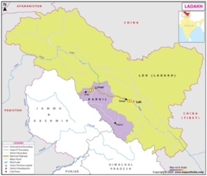
Rajnath lays foundation stone for Nyoma airfield
(General Studies- Paper III)

Source : TH
On September 12, Defence Minister Rajnath Singh virtually laid the foundation stone for the Nyoma airfield in Eastern Ladakh.
- The Nyoma airfield is located very close to the Line of Actual Control (LAC).
- The project is expected to cost approximately ₹200 crore and aims to boost air infrastructure in Ladakh.
- Once completed in about two years, the runway will be capable of accommodating all fighter jets in the Indian Air Force’s (IAF) inventory.
Key Highlights
- Inauguration of Infrastructure Projects:
- Rajnath Singh inaugurated a total of 90 infrastructure projects built by the Border Roads Organisation (BRO).
- These projects were inaugurated across 11 States and Union Territories and have a combined cost of over ₹2,900 crore.
- The projects include two revamped airfields (Bagdogra and Barrackpore in West Bengal), two helipads, 22 roads, and 63 bridges.
- The projects are strategically significant for enhancing connectivity and security in border regions.
- Distribution of Projects:
- Out of the 90 projects, 36 are in Arunachal Pradesh, 26 in Ladakh, 11 in Jammu & Kashmir, five in Mizoram, three in Himachal Pradesh, two each in Sikkim, Uttarakhand, and West Bengal, and one each in Nagaland, Rajasthan, and the Andaman & Nicobar Islands.
- Significance of Nechiphu Tunnel:
- The Nechiphu tunnel, which is 500 meters long, is a crucial infrastructure project on the Balipara-Charduar-Tawang Road in Arunachal Pradesh.
- Construction work on the tunnel began in October 2020, and it is designed to provide all-weather connectivity to the strategic Tawang Region.
About Border Roads Organisation (BRO)
- The Border Roads Organisation (BRO) is a specialized government agency in India.
- The BRO was founded on May 7, 1960, under the Ministry of Defence, Government of India.
- The primary mandate of the BRO is to construct and maintain roads, bridges, tunnels, and other critical infrastructure in strategically important border areas.
- These areas are often characterized by rugged terrain, high altitudes, and adverse climatic conditions.
- The BRO operates in various border regions of India, including those near the Line of Actual Control (LAC) with China, the Line of Control (LoC) with Pakistan, and areas along the borders with Nepal, Bhutan, and Myanmar.
About Ladakh
- Ladakh is a region located in the northernmost part of India, nestled in the Himalayas and Karakoram mountain ranges.
- It is a high-altitude desert region known for its stunning landscapes, Buddhist culture, and strategic importance.
- Geography:
- Ladakh is situated in the northernmost region of the Indian subcontinent.
- It shares borders with Pakistan-occupied Gilgit-Baltistan to the west, China’s Tibet Autonomous Region to the north and east, Himachal Pradesh to the south, and Jammu and Kashmir to the west.
- Ladakh is characterized by its high altitude, with most areas situated at altitudes ranging from 9,800 feet (3,000 meters) to over 17,000 feet (5,180 meters) above sea level.
- Buddhist Influence:
- Ladakh has a strong Buddhist cultural influence and is often referred to as “Little Tibet.”
- The majority of the population practices Tibetan Buddhism, and the region is dotted with monasteries, stupas, and prayer flags.
- Pangong Lake, Tso Moriri Lake, Nubra Valley, and Zanskar Valley are all present in Ladakh.
Note: In 2019, Ladakh was reorganized into a separate union territory of India, distinct from the former state of Jammu and Kashmir.