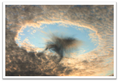
Cavum Cloud
Cavum Cloud
In a recent post, NASA shared a captivating photograph captured by the Terra satellite on January 30, showcasing peculiar holes in the clouds above the Gulf of Mexico and off the coast of Florida.
- These mysterious formations, known as “cavum clouds” or “hole-punch clouds,” have intrigued scientists for over a decade.
What is s Cavum Cloud?
- A Cavum cloud, also known as a fallstreak hole, is a distinctive cloud feature characterized by a well-defined circular or sometimes linear hole in a thin layer of supercooled water droplet cloud.
- Characteristics and Formation
- Cloud Types: Cavum clouds can be found in cirrocumulus, altocumulus, and stratocumulus clouds.
- Appearance: They appear as giant holes in the cloud layer with virga wisps falling underneath the hole, creating a visually striking appearance.
- Nicknames: Cavum clouds are also known by various nicknames like fallstreak hole, hole punch cloud, cloud cavity, skypunch cloud, and cloud canal.
- Formation: These clouds are often formed when an aircraft flies through a thin cumuliform cloud layer, triggering glaciation where water droplets transform into ice particles, creating a gap in the cloud layer with descending ice particles.
- Frequency: Fallstreak holes are more common in altocumulus layers when triggered by aircraft but can also form naturally in cirrocumulus layers without aircraft involvement.
- Significance and Observation
- Observation: Cavum clouds are often mistaken for unusual shapes like flying saucers due to their distinct appearance.
- Location: They are most frequently found in altocumulus clouds, followed by cirrocumulus and stratocumulus clouds.

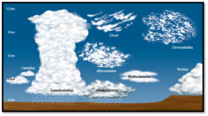
What are ‘cirrocumulus, altocumulus, and stratocumulus clouds’?
- Cirrocumulus Clouds:
- Altitude:
- Cirrocumulus clouds are high-altitude clouds found in the atmosphere’s uppermost layer, typically at an altitude of 20,000 to 40,000 feet (6,000 to 12,000 meters).
- Appearance:
- These clouds appear as small, white patches or rows of clouds with a rippled or textured appearance.
- They often cover the sky in a pattern resembling fish scales or the scales on the skin of a mackerel.
- Formation:
- Cirrocumulus clouds usually form in cold and stable atmospheric conditions, often associated with fair weather.
- They are composed of ice crystals due to the low temperatures at their high altitude.
- Altocumulus Clouds:
- Altitude:
- Altocumulus clouds occupy a middle-altitude range, typically found between 6,500 to 20,000 feet (2,000 to 6,000 meters) above sea level.
- Appearance:
- Altocumulus clouds are characterized by gray or white layers or patches covering the sky.
- They can have a variety of shapes, including rounded masses, rolls, or waves.
- These clouds often appear before a storm, but they can also form under stable atmospheric conditions.
- Formation:
- Altocumulus clouds are formed from water droplets or ice crystals and may indicate changes in the weather, such as an approaching warm or occluded front.
- Stratocumulus Clouds:
- Altitude:
- Stratocumulus clouds are found at lower altitudes, typically ranging from the surface up to 6,500 feet (2,000 meters).
- Appearance:
- These clouds often form as low, gray layers with a relatively uniform appearance.
- They may cover the sky but usually do not reach the ground as precipitation.
- Stratocumulus clouds can also appear as lumpy patches or rolls.
- Formation:
- Stratocumulus clouds form in stable atmospheric conditions, often associated with a lack of significant vertical air movement.
- While they can bring light rain or drizzle, they are not typically associated with heavy precipitation.
- Altitude:
- Altitude:
- Altitude: